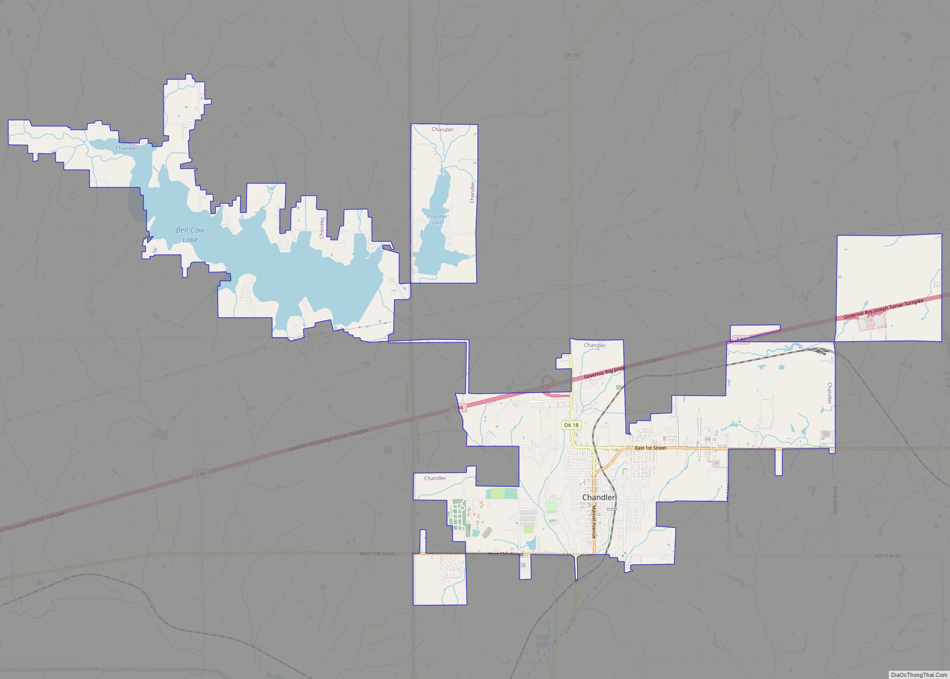
Map of Central High town
Central High is a town in Stephens County, Oklahoma, United States. The population was 1,199 at the 2010 census, an increase of 25.7 percent from the figure of 954 in 2000. Central High town overview: Name: Central High town LSAD Code: 43 LSAD Description: town (suffix) State: Oklahoma County: Stephens County Elevation: 1,181 ft (360 m) Total ... Read more
Map of Central High town
Map of Centrahoma city
Centrahoma is a rural small town in Coal County, Oklahoma, United States. The population was 97 at the 2010 census. Centrahoma city overview: Name: Centrahoma city LSAD Code: 25 LSAD Description: city (suffix) State: Oklahoma County: Coal County Elevation: 709 ft (216 m) Total Area: 0.25 sq mi (0.65 km²) Land Area: 0.25 sq mi (0.65 km²) Water Area: 0.00 sq mi (0.00 km²) Total Population: ... Read more
Map of Centrahoma city
Map of Cement town
Cement is a town in Caddo County, Oklahoma, United States. The population was 501 at the 2010 census. The community was named for its early cement industry. Cement town overview: Name: Cement town LSAD Code: 43 LSAD Description: town (suffix) State: Oklahoma County: Caddo County Elevation: 1,457 ft (444 m) Total Area: 0.48 sq mi (1.25 km²) Land Area: 0.48 sq mi ... Read more
Map of Cement town
Map of Chester CDP, Oklahoma
Chester is a census-designated place and unincorporated community in Major County, Oklahoma, United States. The post office opened April 8, 1895; the ZIP Code is 73838. It is said to have been named for Chester I. Long, U.S. Senator from Kansas. Chester CDP overview: Name: Chester CDP LSAD Code: 57 LSAD Description: CDP (suffix) State: ... Read more
Map of Chester CDP, Oklahoma
Map of Clayton town, Oklahoma
Clayton is a town in northern Pushmataha County, Oklahoma, United States. The population was 821 at the 2010 census. Clayton town overview: Name: Clayton town LSAD Code: 43 LSAD Description: town (suffix) State: Oklahoma County: Pushmataha County Elevation: 607 ft (185 m) Total Area: 1.70 sq mi (4.41 km²) Land Area: 1.68 sq mi (4.35 km²) Water Area: 0.02 sq mi (0.06 km²) Total Population: 555 ... Read more
Map of Clayton town, Oklahoma
Map of Clarita CDP
Clarita CDP overview: Name: Clarita CDP LSAD Code: 57 LSAD Description: CDP (suffix) State: Oklahoma FIPS code: 4014750 Online Interactive Map Clarita online map. Source: Basemap layers from Google Map, Open Street Map (OSM), Arcgisonline, Wmflabs. Boundary Data from Database of Global Administrative Areas. Clarita location map. Where is Clarita CDP? Clarita Road Map Clarita ... Read more
Map of Clarita CDP
Map of Claremore city
Claremore is a city and the county seat of Rogers County in Green Country or northeastern Oklahoma, United States. The population was 19,580 at the 2020 census, a 5.4 percent increase over the figure of 18,581 recorded in 2010. Located in the foothills of the Ozark Mountains, the town is part of the Tulsa Metropolitan ... Read more
Map of Claremore city
Map of Cimarron City town
Cimarron City is a town in Logan County, Oklahoma, United States. The population was 150 at the 2010 census, a 39.4 percent gain over the figure of 110 in 2000. It is part of the Oklahoma City Metropolitan Statistical Area. Cimarron City is a combination bedroom and retirement community. Cimarron City town overview: Name: Cimarron ... Read more
Map of Cimarron City town
Map of Christie CDP
Christie is a census-designated place (CDP) in Adair County, Oklahoma, United States. The population was 218 at the 2010 census, a 31.3 percent increase over the figure of 166 recorded in 2000. Christie CDP overview: Name: Christie CDP LSAD Code: 57 LSAD Description: CDP (suffix) State: Oklahoma County: Adair County Elevation: 873 ft (266 m) Total Area: ... Read more
Map of Christie CDP
Map of Chouteau town
Chouteau /ʃoʊˈtoʊ/ is the second-largest town in Mayes County, Oklahoma, United States. The population was 2,097 at the 2010 census, an increase of 8.6 percent over the figure of 1,931 recorded in 2000. Chouteau town overview: Name: Chouteau town LSAD Code: 43 LSAD Description: town (suffix) State: Oklahoma County: Mayes County Elevation: 627 ft (191 m) Total ... Read more
Map of Chouteau town
Map of Choctaw city, Oklahoma
Choctaw is a city in Oklahoma County, Oklahoma, United States, with a population of 12,182 at the 2020 census, a 9.3% increase from 2010. It is the oldest chartered town in Oklahoma Territory. The city is located approximately 10 miles (16.1 km) east of Oklahoma City and is part of the Oklahoma City metropolitan area. Choctaw ... Read more
Map of Choctaw city, Oklahoma
Map of Chickasha city
Chickasha /ˈtʃɪkəʃeɪ/ is a city in and the county seat of Grady County, Oklahoma, United States. The population was 16,051 at the 2020 census, a 0.1% increase from 2010. Chickasha is home to the University of Science and Arts of Oklahoma. The city is named for and strongly connected to Native American heritage, as “Chickasha” ... Read more
Map of Chickasha city