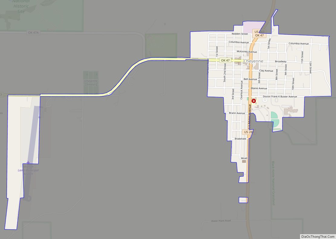
Map of Claremore city

Map of Claremore city

Claremore is a city and the county seat of Rogers County in Green Country or northeastern Oklahoma, United States. The population was 19,580 at the 2020 census, a 5.4 percent increase over the figure of 18,581 recorded in 2010. Located in the foothills of the Ozark Mountains, the town is part of the Tulsa Metropolitan … Read more

Map of Cimarron City town

Map of Cimarron City town

Cimarron City is a town in Logan County, Oklahoma, United States. The population was 150 at the 2010 census, a 39.4 percent gain over the figure of 110 in 2000. It is part of the Oklahoma City Metropolitan Statistical Area. Cimarron City is a combination bedroom and retirement community. Cimarron City town overview: Name: Cimarron … Read more

Map of Cole town

Map of Cole town

Cole is a town in McClain County, Oklahoma, United States. The population was 624 at the 2020 census, up from 555 at the 2010 census. Cole town overview: Name: Cole town LSAD Code: 43 LSAD Description: town (suffix) State: Oklahoma County: McClain County Elevation: 1,145 ft (349 m) Total Area: 15.07 sq mi (39.03 km²) Land Area: 14.98 sq mi (38.80 km²) Water … Read more

Map of Colcord town

Map of Colcord town

Colcord is a town in southern Delaware County, Oklahoma, United States. The community lies in the northeastern part of the state in a region known as Green Country. The population was 815 at the 2010 census, a decline of 0.5 percent from the figure of 819 recorded in 2000. Colcord town overview: Name: Colcord town … Read more

Map of Colbert town, Oklahoma

Map of Colbert town, Oklahoma

Colbert is a town in Bryan County, Oklahoma, United States. The population was 1,140 at the 2010 census, a 7 percent increase over the figure of 1,065 recorded in 2000. It was incorporated in 1939. Colbert town overview: Name: Colbert town LSAD Code: 43 LSAD Description: town (suffix) State: Oklahoma County: Bryan County Elevation: 663 ft … Read more

Map of Coalgate city

Map of Coalgate city

Coalgate is a city in and the county seat of Coal County, Oklahoma, United States. The population was 1,967 at the 2010 census, a 1.9 percent decrease from the figure of 2,005 recorded in 2000. The town was founded in 1889 in the Choctaw Nation, Indian Territory as a coal mining camp named Liddle. The … Read more

Map of Cloud Creek CDP

Map of Cloud Creek CDP

Cloud Creek is an unincorporated community and census-designated place (CDP) in Delaware County, Oklahoma, United States. The population was 121 at the 2010 census, a 40.7 percent increase over the figure of 86 recorded in 2000 census. Cloud Creek CDP overview: Name: Cloud Creek CDP LSAD Code: 57 LSAD Description: CDP (suffix) State: Oklahoma County: … Read more

Map of Clinton city, Oklahoma

Map of Clinton city, Oklahoma

Clinton is a city in Custer and Washita counties in the U.S. state of Oklahoma. The population was 9,033 at the 2010 census. Clinton city overview: Name: Clinton city LSAD Code: 25 LSAD Description: city (suffix) State: Oklahoma County: Custer County, Washita County Elevation: 1,565 ft (477 m) Total Area: 9.97 sq mi (25.81 km²) Land Area: 9.95 sq mi (25.76 km²) Water … Read more

Map of Cleveland city, Oklahoma

Map of Cleveland city, Oklahoma

Cleveland is a city in Pawnee County, Oklahoma, United States. The 2010 census population was 3,251, a decrease of 0.9 percent from the figure of 3,282 recorded in 2000. Cleveland city overview: Name: Cleveland city LSAD Code: 25 LSAD Description: city (suffix) State: Oklahoma County: Pawnee County Elevation: 778 ft (237 m) Total Area: 2.69 sq mi (6.96 km²) Land … Read more

Map of Cleora CDP

Map of Cleora CDP

Cleora is an unincorporated community and census-designated place (CDP) in Delaware County, Oklahoma, United States, along State Highway 85. The population was 1,463 at the 2010 census, up from the figure of 1,113 recorded in 2000. The Cleora Post Office existed from November 28, 1900, until October 15, 1954. Cleora was established in District 2 … Read more

Map of Cleo Springs town

Map of Cleo Springs town

Cleo Springs (originally known as Cleo) is a town in Major County, Oklahoma, United States. The population was 326 at the 2000 census. Cleo Springs town overview: Name: Cleo Springs town LSAD Code: 43 LSAD Description: town (suffix) State: Oklahoma County: Major County Elevation: 1,276 ft (389 m) Total Area: 0.55 sq mi (1.43 km²) Land Area: 0.55 sq mi (1.43 km²) Water … Read more

Map of Clearview town

Map of Clearview town, Oklahoma

Clearview is a town in Okfuskee County, Oklahoma, United States. The population was 56 at the 2000 census. It was historically an all-black freedmen’s town and was platted by the Lincoln Townsite Company and designated as Lincoln. Clearview town overview: Name: Clearview town LSAD Code: 43 LSAD Description: town (suffix) State: Oklahoma County: Okfuskee County … Read more