Map of Elgin city, Oklahoma

Map of Elgin city, Oklahoma

Elgin is a city in northeastern Comanche County, Oklahoma, United States. The population was 2,156 at the 2010 census, a 78 percent increase from 1,210 at the 2000 census. It is included in the Lawton, Oklahoma Metropolitan Statistical Area. It is the site of Fort Sill National Cemetery. Elgin city overview: Name: Elgin city LSAD … Read more

Map of Eldorado town, Oklahoma

Map of Eldorado town, Oklahoma

Eldorado is a town in Jackson County, Oklahoma, United States. The population was 446 at the 2010 census. The Southern Baptist pastor, W. A. Criswell, was born in Eldorado in 1909. He was the long-term pastor of the First Baptist Church of Dallas, Texas. Eldorado town overview: Name: Eldorado town LSAD Code: 43 LSAD Description: … Read more

Map of Eldon CDP, Oklahoma

Map of Eldon CDP, Oklahoma

Eldon is an unincorporated community and census-designated place (CDP) in Cherokee County, Oklahoma, United States. The population was 368 at the 2010 census, a loss of 62.3 percent from 991 at the 2000 census, due largely to shrinkage of the CDP boundaries. It lies east of Tahlequah at the junction of U.S. Highway 62 and … Read more

Map of Erick city

Map of Erick city

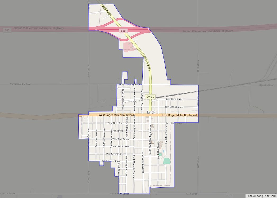
Erick (/ˈɪərɪk/ EER-ik) is a city in Beckham County, Oklahoma, United States. It is located 15 miles (24 km) west of Sayre, the county seat, and 6 miles (9.7 km) east of the Oklahoma-Texas border. The population was 1,052 at the 2010 census. A post office, originally named Dennis, was established to serve the local community on … Read more

Map of Enid city

Map of Enid city

Enid (/ˈiːnɪd/ EE-nid) is the ninth-largest city in the U.S. state of Oklahoma. It is the county seat of Garfield County. As of the 2020 census, the population was 51,308. Enid was founded during the opening of the Cherokee Outlet in the Land Run of 1893, and is named after Enid, a character in Alfred, … Read more

Map of Empire City town

Map of Empire City town

Empire City, or simply Empire, is a town in Stephens County, Oklahoma, United States. The population was 955 at the 2010 census. Empire City town overview: Name: Empire City town LSAD Code: 43 LSAD Description: town (suffix) State: Oklahoma County: Stephens County Elevation: 1,066 ft (325 m) Total Area: 9.49 sq mi (24.57 km²) Land Area: 9.32 sq mi (24.13 km²) Water Area: … Read more

Map of Elmore City town

Map of Elmore City town

Elmore City is a town in Garvin County, Oklahoma, United States. This town is fifty-eight miles south of Oklahoma City. The population was 697 at the 2010 census. It was named after J. O. Elmore. There are two main highways running through Elmore City. One of the Highways is Oklahoma State Highway 29, running west–east. … Read more

Map of Elmer town, Oklahoma

Map of Elmer town, Oklahoma

Elmer is a town in Jackson County, Oklahoma, United States. The population was 96 at the 2010 census. Elmer town overview: Name: Elmer town LSAD Code: 43 LSAD Description: town (suffix) State: Oklahoma County: Jackson County Elevation: 1,309 ft (399 m) Total Area: 0.42 sq mi (1.09 km²) Land Area: 0.42 sq mi (1.09 km²) Water Area: 0.00 sq mi (0.00 km²) Total Population: 65 Population … Read more

Map of Elm Grove CDP

Map of Elm Grove CDP, Oklahoma

Elm Grove is a census-designated place (CDP) in Adair County, Oklahoma, United States. The population was 198 at the 2010 census. Elm Grove CDP overview: Name: Elm Grove CDP LSAD Code: 57 LSAD Description: CDP (suffix) State: Oklahoma County: Adair County Elevation: 1,050 ft (320 m) Total Area: 2.43 sq mi (6.30 km²) Land Area: 2.42 sq mi (6.28 km²) Water Area: 0.01 sq mi … Read more

Map of Elk City, Oklahoma

Map of Elk City, Oklahoma

Elk City is a city in Beckham County, Oklahoma, United States. The population was 11,693 at the 2010 census, and the population was estimated at 11,577 in 2019. Elk City is located on Interstate 40 and Historic U.S. Route 66 in western Oklahoma, approximately 110 miles (180 km) west of Oklahoma City and 150 miles (240 km) … Read more

Map of Fairmont town, Oklahoma

Map of Fairmont town, Oklahoma

Fairmont is a town in Garfield County, Oklahoma, United States. The population was 134 at the 2010 census, a decrease from 147 at the 2000 census. Fairmont town overview: Name: Fairmont town LSAD Code: 43 LSAD Description: town (suffix) State: Oklahoma County: Garfield County Elevation: 1,204 ft (367 m) Total Area: 0.24 sq mi (0.62 km²) Land Area: 0.24 sq mi (0.62 km²) … Read more

Map of Fairland town, Oklahoma

Map of Fairland town, Oklahoma

Fairland is a town in southern Ottawa County, Oklahoma, United States. The population was 1,057 at the 2010 U. S. Census, an increase from the figure of 1,025 recorded in 2000. The town is in the historic Cherokee Nation. Fairland town overview: Name: Fairland town LSAD Code: 43 LSAD Description: town (suffix) State: Oklahoma County: … Read more