Map of Nardin CDP

Map of Nardin CDP

Nardin is a census-designated place (CDP) and unincorporated community in Kay County, Oklahoma, United States. Its population was 52 as of the 2010 census. Nardin CDP overview: Name: Nardin CDP LSAD Code: 57 LSAD Description: CDP (suffix) State: Oklahoma County: Kay County Elevation: 1,086 ft (331 m) Total Area: 1.04 sq mi (2.69 km²) Land Area: 1.04 sq mi (2.69 km²) Water Area: … Read more

Map of Narcissa CDP

Map of Narcissa CDP

Narcissa is a census-designated place (CDP) in Ottawa County, Oklahoma, United States. The population was 100 at the 2000 census. Narcissa is part of the Joplin, Missouri metropolitan area. Historic U.S. Route 66 ran through it. The Narcissa D-X Gas Station is listed on the National Register of Historic Places. Narcissa CDP overview: Name: Narcissa … Read more

Map of Mutual town, Oklahoma

Map of Mutual town, Oklahoma

Mutual is a town in Woodward County, Oklahoma, United States. The population was 61 at the 2010 census. Incorporated in 1908, the town suffered under the agricultural depression after World War I and saw only minimal growth during the 1970s and 1980s. Mutual town overview: Name: Mutual town LSAD Code: 43 LSAD Description: town (suffix) … Read more

Map of Newcastle city, Oklahoma

Map of Newcastle city, Oklahoma

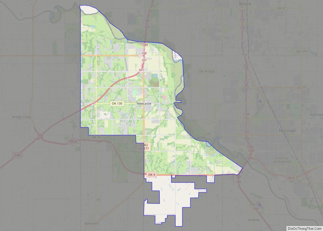
Newcastle is a city in McClain County, Oklahoma, United States, and part of the Oklahoma City Metropolitan Area. As of the 2020 Census, the population was 10,984, a 42.9% increase from 2010. Newcastle city overview: Name: Newcastle city LSAD Code: 25 LSAD Description: city (suffix) State: Oklahoma County: McClain County Founded: 1894 Incorporated: 1962, 1965 … Read more

Map of New Woodville town

Map of New Woodville town

New Woodville town overview: Name: New Woodville town LSAD Code: 43 LSAD Description: town (suffix) State: Oklahoma County: Marshall County FIPS code: 4051750 Online Interactive Map New Woodville online map. Source: Basemap layers from Google Map, Open Street Map (OSM), Arcgisonline, Wmflabs. Boundary Data from Database of Global Administrative Areas. New Woodville location map. Where … Read more

Map of New Eucha CDP

Map of New Eucha CDP

New Eucha is a census-designated place (CDP) in Delaware County, Oklahoma, United States. The population was 405 at the 2010 census, up from the figure of 300 recorded in 2000. New Eucha CDP overview: Name: New Eucha CDP LSAD Code: 57 LSAD Description: CDP (suffix) State: Oklahoma County: Delaware County Elevation: 1,110 ft (340 m) Total Area: … Read more

Map of New Cordell city

Map of New Cordell city

New Cordell is a city in, and county seat of, Washita County, Oklahoma, United States. It lies along U.S. Route 183. The population was 2,915 at the 2010 census. The community was previously established a few miles from the current site, but was moved about 1900. It was named for a U.S. Postal Service employee … Read more

Map of New Alluwe town

Map of New Alluwe town

New Alluwe is a town in Nowata County, Oklahoma, United States. The population was 95 at the 2000 census. New Alluwe town overview: Name: New Alluwe town LSAD Code: 43 LSAD Description: town (suffix) State: Oklahoma County: Nowata County Total Area: 0.12 sq mi (0.30 km²) Land Area: 0.12 sq mi (0.30 km²) Water Area: 0.00 sq mi (0.00 km²) Total Population: 89 Population … Read more

Map of Nescatunga CDP

Map of Nescatunga CDP

Nescatunga is an unincorporated census-designated place (CDP) in Alfalfa County, Oklahoma, United States adjacent to Great Salt Plains State Park. The population was 70 as of the 2010 census. Nescatunga CDP overview: Name: Nescatunga CDP LSAD Code: 57 LSAD Description: CDP (suffix) State: Oklahoma County: Alfalfa County Elevation: 1,145 ft (349 m) Total Area: 0.23 sq mi (0.58 km²) Land … Read more

Map of Nash town, Oklahoma

Map of Nash town, Oklahoma

Nash is a town in Grant County, Oklahoma, United States. The population was 204 at the 2010 census, an 8.9 percent decline from the figure of 224 in 2000. Nash once shared a school district with the town of Jet, several miles away along U.S. Route 64, but the school folded in 2013 and high … Read more

Map of North Miami town, Oklahoma

Map of North Miami town, Oklahoma

North Miami is a town in Ottawa County, Oklahoma, United States. The population was 290 at the 2020 census. North Miami is part of the Joplin, Missouri metropolitan area. The town is primarily a bedroom community for several larger towns in the county. North Miami town overview: Name: North Miami town LSAD Code: 43 LSAD … Read more

Map of North Enid town

Map of North Enid town

North Enid is a town in Garfield County, Oklahoma, United States. The population was 860 at the 2010 census. The town is served by the Chisholm school district. North Enid was the original railroad town site in the Enid–Pond Creek Railroad War. North Enid town overview: Name: North Enid town LSAD Code: 43 LSAD Description: … Read more