Map of Ralston town, Oklahoma
Ralston (Pawnee: Iriíraatuhukaataku, reetuhruukaataku ) is a town in Pawnee County, Oklahoma, United States. The town is southeast of Ponca City on State Highway 18 near the west bank of the Arkansas River. The population was 330 at the 2010 census, a decline of 7 percent from the figure of 355 recorded in 2000. Ralston ... Read more
Map of Ralston town, Oklahoma
Map of Quinton town, Oklahoma
Quinton is a town in Pittsburg County, Oklahoma, United States. The population was 1,051 at the 2010 census. The town was named for Elizabeth Quinton, who lived to be 116 years old. Her family still resides in and around the town of Quinton. Quinton town overview: Name: Quinton town LSAD Code: 43 LSAD Description: town ... Read more
Map of Quinton town, Oklahoma
Map of Quapaw town
Quapaw is a town in Ottawa County, Oklahoma, United States. Its population was 906 at the 2010 census, a 7.9% decline from the 984 recorded in 2000. Quapaw is part of the Joplin, Missouri metropolitan area. Quapaw town overview: Name: Quapaw town LSAD Code: 43 LSAD Description: town (suffix) State: Oklahoma County: Ottawa County Elevation: ... Read more
Map of Quapaw town
Map of Red Rock town, Oklahoma
Red Rock (Iowa-Oto: Chína Ino Šúje pronounced ĩꜜno suꜜdʒɛ, meaning “Rock Red town”) is a town in northern Noble County, Oklahoma, United States. The population was 283 at the 2010 census, a decline from 293 at the 2000 census. The headquarters of the Otoe-Missouria Tribe of Indians is located in Red Rock. Red Rock town ... Read more
Map of Red Rock town, Oklahoma
Map of Red Oak town, Oklahoma
Red Oak is a town in Latimer County, Oklahoma, United States. The population was 549 at the 2010 census. Eight miles northeast of the present town is the original site of Red Oak. There in 1850 Thomas Edwards established a trading post on the Fort Smith–Boggy Depot Road. With the advent of the Butterfield Overland ... Read more
Map of Red Oak town, Oklahoma
Map of Ravia town
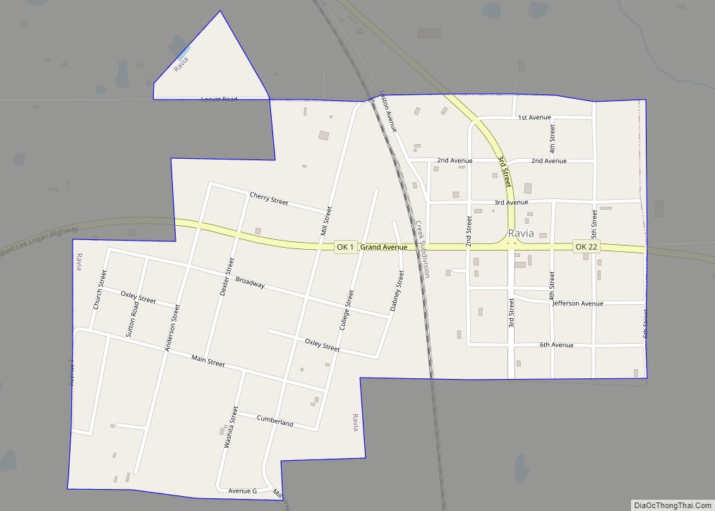
Ravia is a town in Johnston County, Oklahoma, United States. The population was 528 at the 2010 census, up from 459 in 2000. Ravia town overview: Name: Ravia town LSAD Code: 43 LSAD Description: town (suffix) State: Oklahoma County: Johnston County Elevation: 764 ft (233 m) Total Area: 0.57 sq mi (1.47 km²) Land Area: 0.57 sq mi (1.47 km²) Water Area: 0.00 sq mi ... Read more
Map of Ravia town
Map of River Bottom CDP
River Bottom is a census-designated place (CDP) in Muskogee County, Oklahoma, United States. The population was 265 at the 2000 census. River Bottom CDP overview: Name: River Bottom CDP LSAD Code: 57 LSAD Description: CDP (suffix) State: Oklahoma County: Muskogee County Total Area: 9.36 sq mi (24.24 km²) Land Area: 9.36 sq mi (24.24 km²) Water Area: 0.00 sq mi (0.00 km²) Total Population: ... Read more
Map of River Bottom CDP
Map of Ripley town, Oklahoma
Ripley is a town in southeastern Payne County, Oklahoma, United States. The population was 423 at the 2010 census, a decline of 9.2 percent from the figure of 444 in 2000. The town was named after Edward Ripley, the 14th president of the Atchison, Topeka and Santa Fe Railway. Ripley town overview: Name: Ripley town ... Read more
Map of Ripley town, Oklahoma
Map of Ringwood town, Oklahoma
Ringwood is a town in Major County, Oklahoma, United States. The population was 497 at the 2010 census, a 17.2 percent increase from the 2000 census. The population is now estimated to be 510. The town was given its name because it was ringed by woods from northwest to southeast, though the town is no ... Read more
Map of Ringwood town, Oklahoma
Map of Ringling town
Ringling is a town in Jefferson County, Oklahoma, United States. The population was 1,037 at the 2010 census, a decline of 8.6 percent from the figure of 1,135 in 2000. It was named for John Ringling, the founder of the Ringling Brothers Circus. Ringling town overview: Name: Ringling town LSAD Code: 43 LSAD Description: town ... Read more
Map of Ringling town
Map of Reydon town
Reydon is a town in Roger Mills County, Oklahoma, United States. Reydon was established in 1928 after the Atchison, Topeka and Santa Fe Railway put down rails in the area, purchased land from local farmers, and laid out a townsite. The site was two miles north of a settlement called Rankin, and Rankin merchants moved ... Read more
Map of Reydon town
Map of Rentiesville town
Rentiesville is a town in McIntosh County, Oklahoma, United States. It was founded in 1903 and named for William Rentie, a local landowner. It was one of 50 all-black towns in Oklahoma and one of 13 that still survives. The population was 128 at the 2010 census, an increase of 25.5 percent from 102 in ... Read more
Map of Rentiesville town