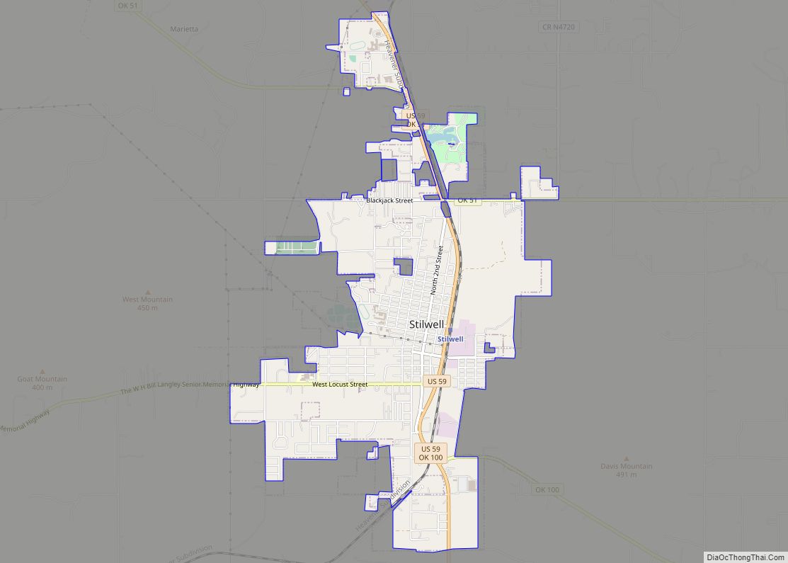
Map of Stidham town

Map of Stidham town

Stidham is a town in McIntosh County, Oklahoma, United States. The population was 16 at the 2010 census, a decline of 21.7 percent from 23 in 2000. Stidham town overview: Name: Stidham town LSAD Code: 43 LSAD Description: town (suffix) State: Oklahoma County: McIntosh County Elevation: 627 ft (191 m) Total Area: 0.03 sq mi (0.08 km²) Land Area: 0.03 sq mi … Read more

Map of Sterling town, Oklahoma

Map of Sterling town, Oklahoma

Sterling is a town in Comanche County, Oklahoma, United States. The population was 793 at the 2010 census. It is part of the Lawton Metropolitan Statistical Area. Sterling town overview: Name: Sterling town LSAD Code: 43 LSAD Description: town (suffix) State: Oklahoma County: Comanche County Elevation: 1,230 ft (375 m) Total Area: 0.82 sq mi (2.13 km²) Land Area: 0.82 sq mi … Read more

Map of Sulphur city, Oklahoma

Map of Sulphur city, Oklahoma

Sulphur is a city in and county seat of Murray County, Oklahoma, United States. The population was 5,065 at the 2020 census, a 2.8 percent gain over the figure of 4,929 in 2010. The area around Sulphur has been noted for its mineral springs, since well before the city was founded late in the 19th … Read more

Map of Sugden town

Map of Sugden town

Sugden is a town in Jefferson County, Oklahoma, United States. The population was 43 at the 2010 census. Sugden town overview: Name: Sugden town LSAD Code: 43 LSAD Description: town (suffix) State: Oklahoma County: Jefferson County Elevation: 846 ft (258 m) Total Area: 0.23 sq mi (0.60 km²) Land Area: 0.23 sq mi (0.60 km²) Water Area: 0.00 sq mi (0.00 km²) Total Population: 22 Population … Read more

Map of Stuart town, Oklahoma

Map of Stuart town, Oklahoma

Stuart is a town in southeastern Hughes County, Oklahoma, United States. The population was 180 at the 2010 census, down from 220 in 2000. Stuart town overview: Name: Stuart town LSAD Code: 43 LSAD Description: town (suffix) State: Oklahoma County: Hughes County Elevation: 735 ft (224 m) Total Area: 0.27 sq mi (0.71 km²) Land Area: 0.27 sq mi (0.71 km²) Water Area: … Read more

Map of Stroud city

Map of Stroud city

Stroud is a city in Creek and Lincoln counties in the U.S. state of Oklahoma. As of the 2010 census, the city population was 2,690. Stroud city overview: Name: Stroud city LSAD Code: 25 LSAD Description: city (suffix) State: Oklahoma County: Creek County, Lincoln County Elevation: 890 ft (270 m) Total Area: 12.70 sq mi (32.90 km²) Land Area: 11.63 sq mi … Read more

Map of Strong City town, Oklahoma

Map of Strong City town, Oklahoma

Strong City is a town in Roger Mills County, Oklahoma, United States. The population was 47 at the 2010 census. Strong City town overview: Name: Strong City town LSAD Code: 43 LSAD Description: town (suffix) State: Oklahoma County: Roger Mills County Elevation: 1,883 ft (574 m) Total Area: 0.50 sq mi (1.29 km²) Land Area: 0.50 sq mi (1.29 km²) Water Area: 0.00 sq mi … Read more

Map of Taft town, Oklahoma

Map of Taft town, Oklahoma

Taft is a town in Muskogee County, Oklahoma, United States. The population was 250 at the 2010 census, a decline of 28.4 percent from the figure of 349 recorded in 2000. The town began as an all-black town on land allotted to Creek Freedmen. It is named for President William Howard Taft. Taft town overview: … Read more

Map of Sycamore CDP, Oklahoma

Map of Sycamore CDP, Oklahoma

Sycamore is a census-designated place (CDP) in Delaware County, Oklahoma, United States. The population was 177 at the 2010 census. Sycamore CDP overview: Name: Sycamore CDP LSAD Code: 57 LSAD Description: CDP (suffix) State: Oklahoma County: Delaware County Elevation: 1,120 ft (340 m) Total Area: 2.98 sq mi (7.71 km²) Land Area: 2.98 sq mi (7.71 km²) Water Area: 0.00 sq mi (0.00 km²) Total Population: … Read more

Map of Swink CDP, Oklahoma

Map of Swink CDP, Oklahoma

Swink is an unincorporated community and census-designated place (CDP) in Choctaw County, Oklahoma, United States. As of the 2010 census the population was 66. The population was 83 at the 2000 census, at which time it was a town; the community disincorporated on December 1, 2000. Swink CDP overview: Name: Swink CDP LSAD Code: 57 … Read more

Map of Sweetwater town, Oklahoma

Map of Sweetwater town, Oklahoma

Sweetwater is a town in Beckham and Roger Mills Counties in the U.S. state of Oklahoma. It was incorporated in 1998. As of the 2010 census it had a population of 87. Sweetwater town overview: Name: Sweetwater town LSAD Code: 43 LSAD Description: town (suffix) State: Oklahoma County: Beckham County, Roger Mills County Elevation: 2,172 ft … Read more

Map of Summit town, Oklahoma

Map of Summit town, Oklahoma

Summit is a town in Muskogee County, Oklahoma, United States. It was originally called South Muskogee when it was platted in 1910, and is one of thirteen all-black towns still surviving at the beginning of the 21st Century. The population was 139 at the 2010 census, a 38.5 percent decline from the figure of 226 … Read more