Map of Camargo town, Oklahoma

Map of Camargo town, Oklahoma

Camargo is a town in Dewey County, Oklahoma, United States. The population was 178 at the 2010 census, an increase of 54.8 percent from the figure of 115 in 2000. Camargo town overview: Name: Camargo town LSAD Code: 43 LSAD Description: town (suffix) State: Oklahoma County: Dewey County Elevation: 1,939 ft (591 m) Total Area: 0.25 sq mi (0.64 km²) … Read more

Map of Calvin town, Oklahoma

Map of Calvin town, Oklahoma

Calvin is a town in Hughes County, Oklahoma, United States. The population was 294 at the 2010 census. Calvin town overview: Name: Calvin town LSAD Code: 43 LSAD Description: town (suffix) State: Oklahoma County: Hughes County Elevation: 741 ft (226 m) Total Area: 0.90 sq mi (2.34 km²) Land Area: 0.90 sq mi (2.33 km²) Water Area: 0.00 sq mi (0.00 km²) Total Population: 309 Population … Read more

Map of Calumet town, Oklahoma

Map of Calumet town, Oklahoma

Calumet is a town in Canadian County, Oklahoma, United States. It is part of the Oklahoma City Metropolitan Area. The population was 507 at the 2010 census, a 5.23 percent decrease since 2000. Calumet is a variant term for Ceremonial pipe. Incorporated in 1942, the town’s land was settled in the Land Run of 1892. … Read more

Map of Calera town, Oklahoma

Map of Calera town, Oklahoma

Calera is a town in Bryan County, Oklahoma, United States, located five miles south of Durant and 10 miles north of the Oklahoma-Texas state line. The population was 2,906 at the 2020 census, an increase of 34.2 percent over the figure of 2,164 recorded in 2010 indicating that Calera is experiencing larger growth than Durant … Read more

Map of Caddo town

Map of Caddo town

Caddo is a town in Bryan County, Oklahoma, United States. The population was 997 at the 2010 census, a 5.6 percent gain over the figure of 944 recorded in 2000. The name is derived from a Caddo word, ka do hada’ cho, meaning “real chief” in English. According to Encyclopedia of Oklahoma History and Culture, … Read more

Map of Cache city

Map of Cache city, Oklahoma

Cache is a city in Comanche County, Oklahoma, United States. The population was 2,796 at the 2010 census. It is an exurb included in the Lawton, Oklahoma Metropolitan Statistical Area. It is the location of Star House, the home of the Comanche chief Quanah Parker, the major leader of the Quahadi Comanche in the years … Read more

Map of Byron town, Oklahoma

Map of Byron town, Oklahoma

Byron is a town in Alfalfa County, Oklahoma, United States. The population was 35 at the time of the 2010 census. Byron town overview: Name: Byron town LSAD Code: 43 LSAD Description: town (suffix) State: Oklahoma County: Alfalfa County Elevation: 1,194 ft (364 m) Total Area: 0.25 sq mi (0.65 km²) Land Area: 0.25 sq mi (0.65 km²) Water Area: 0.00 sq mi (0.00 km²) Total … Read more

Map of Byng town

Map of Byng town

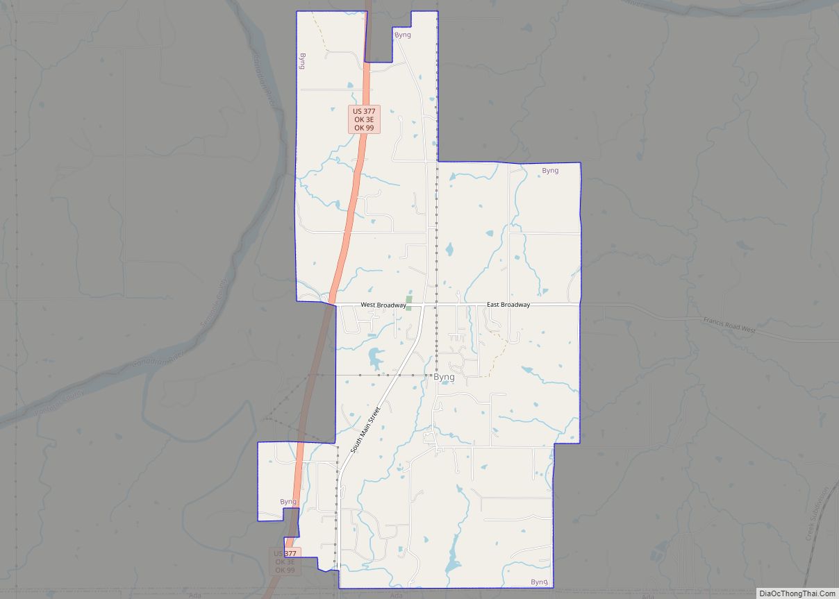
Byng is a town in Pontotoc County, Oklahoma, United States. The population was 1,175 at the 2010 census. Byng town overview: Name: Byng town LSAD Code: 43 LSAD Description: town (suffix) State: Oklahoma County: Pontotoc County Elevation: 974 ft (297 m) Total Area: 6.52 sq mi (16.89 km²) Land Area: 6.52 sq mi (16.89 km²) Water Area: 0.00 sq mi (0.00 km²) Total Population: 1,393 Population … Read more

Map of Byars town

Map of Byars town

Byars is a town in McClain County, Oklahoma, United States. The population was 184 at the 2020 census, down from 255 at the 2010 census. Byars town overview: Name: Byars town LSAD Code: 43 LSAD Description: town (suffix) State: Oklahoma County: McClain County Elevation: 1,030 ft (314 m) Total Area: 1.64 sq mi (4.24 km²) Land Area: 1.53 sq mi (3.97 km²) Water … Read more

Map of Butler CDP, Oklahoma

Map of Butler CDP, Oklahoma

Butler is an unincorporated community and census-designated place (CDP) in Delaware County, Oklahoma, United States. The population was 117 at the 2010 census. Butler CDP overview: Name: Butler CDP LSAD Code: 57 LSAD Description: CDP (suffix) State: Oklahoma County: Delaware County Elevation: 785 ft (239 m) Total Area: 2.80 sq mi (7.25 km²) Land Area: 2.80 sq mi (7.25 km²) Water Area: 0.00 sq mi … Read more

Map of Caney town, Oklahoma

Map of Caney town, Oklahoma

Caney is a town in Atoka County, Oklahoma, United States. The population was 205 at the 2010 census. Caney town overview: Name: Caney town LSAD Code: 43 LSAD Description: town (suffix) State: Oklahoma County: Atoka County Elevation: 600 ft (183 m) Total Area: 0.76 sq mi (1.96 km²) Land Area: 0.76 sq mi (1.96 km²) Water Area: 0.00 sq mi (0.00 km²) Total Population: 185 Population … Read more

Map of Canadian town

Map of Canadian town, Oklahoma

Canadian is a town in Pittsburg County, Oklahoma, United States. The population was 239 at the 2000 census. Canadian town overview: Name: Canadian town LSAD Code: 43 LSAD Description: town (suffix) State: Oklahoma County: Pittsburg County Elevation: 665 ft (203 m) Total Area: 0.76 sq mi (1.96 km²) Land Area: 0.76 sq mi (1.96 km²) Water Area: 0.00 sq mi (0.00 km²) Total Population: 143 Population … Read more