Map of Scio city, Oregon
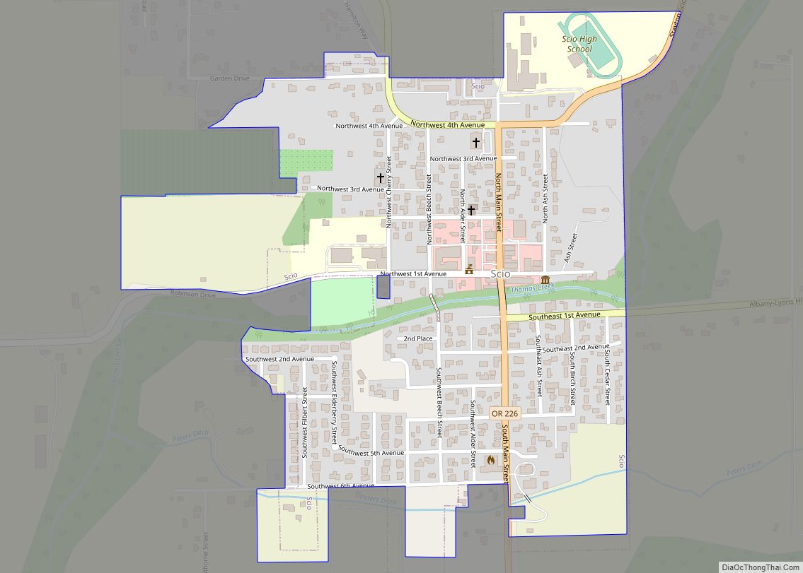
Scio (/ˈsaɪoʊ/ SY-oh) is a city in Linn County, Oregon, United States. The population was 838 at the 2010 census. Scio city overview: Name: Scio city LSAD Code: 25 LSAD Description: city (suffix) State: Oregon County: Linn County Incorporated: 1866 Elevation: 317 ft (96.6 m) Total Area: 0.43 sq mi (1.13 km²) Land Area: 0.43 sq mi (1.13 km²) Water Area: 0.00 sq mi (0.00 km²) ... Read more
Map of Scio city, Oregon
Map of Scappoose city
Scappoose /skæˈpuːs/ is a city in Columbia County, Oregon, United States. It was named for a nearby stream, which drains the southern part of the county. The name “Scappoose” is of Native American origin, and is said to mean “gravelly plain.” The population was 6,592 at the 2010 census. Scappoose city overview: Name: Scappoose city ... Read more
Map of Scappoose city
Map of Sandy city, Oregon
Sandy is a city located in Clackamas County, Oregon, United States, settled c. 1853 and named after the nearby Sandy River. Located in the foothills of the Cascade Mountain Range, the city serves as the western gateway to the Mount Hood Corridor, and is located approximately 27 miles (43 km) east of Portland. The city of ... Read more
Map of Sandy city, Oregon
Map of Rufus city
Rufus is a city in Sherman County, Oregon, United States. The population was 249 at the 2010 census. The city was named for an early settler, Rufus Carrol Wallis. Rufus city overview: Name: Rufus city LSAD Code: 25 LSAD Description: city (suffix) State: Oregon County: Sherman County Incorporated: 1965 Elevation: 235 ft (71.6 m) Total Area: 1.34 sq mi ... Read more
Map of Rufus city
Map of Ruch CDP
Ruch is an unincorporated community and census-designated place (CDP) in Jackson County, Oregon, United States. It is located on Oregon Route 238, southeast of Grants Pass. As of the 2010 census it had a population of 840. Ruch was named for Casper M. Ruch, who bought a tract of land where the community now stands ... Read more
Map of Ruch CDP
Map of Rowena CDP
Rowena is an unincorporated community in Wasco County, Oregon, United States. For statistical purposes, the United States Census Bureau has defined Rowena as a census-designated place (CDP). The census definition of the area may not precisely correspond to local understanding of the area with the same name. The population was 187 at the 2010 census. ... Read more
Map of Rowena CDP
Map of Sherwood city, Oregon
Sherwood is a city in Washington County, Oregon, United States. Located in the southeast corner of the county, it is a residential community in the Tualatin Valley, southwest of Portland. As of the 2010 census, Sherwood had a population of 18,194 residents. The city’s population for 2019 was estimated to be 19,879 by the U.S. ... Read more
Map of Sherwood city, Oregon
Map of Sheridan city, Oregon
Sheridan is a city in Yamhill County, Oregon, United States. Platted in the 1860s when it received a post office, the city was incorporated in 1880. A major fire burned much of the city in 1913, and a flood covered much of the city in 1964. The population of the city as of the 2020 ... Read more
Map of Sheridan city, Oregon
Map of Shedd CDP
Shedd is an unincorporated community and census-designated place (CDP) in Linn County, Oregon, United States, on Oregon Route 99E. As of the 2010 census it had a population of 204. Shedd CDP overview: Name: Shedd CDP LSAD Code: 57 LSAD Description: CDP (suffix) State: Oregon County: Linn County Elevation: 266 ft (81 m) Total Area: 1.51 sq mi (3.91 km²) ... Read more
Map of Shedd CDP
Map of Shaniko city
Shaniko (/ˈʃænɪkoʊ/, SHAN-i-koh) is a city located in Wasco County, Oregon, United States, on U.S. Route 97 and about 8 miles (13 km) north of Antelope. The population was 30 at the 2020 census. Shaniko city overview: Name: Shaniko city LSAD Code: 25 LSAD Description: city (suffix) State: Oregon County: Wasco County Incorporated: 1901 Elevation: 3,343 ft ... Read more
Map of Shaniko city
Map of Shady Cove city
Shady Cove is a city in Jackson County, Oregon, United States. The population was 2,904 at the 2010 census. Shady Cove city overview: Name: Shady Cove city LSAD Code: 25 LSAD Description: city (suffix) State: Oregon County: Jackson County Incorporated: 1972 Elevation: 1,406 ft (428.6 m) Total Area: 2.05 sq mi (5.30 km²) Land Area: 1.95 sq mi (5.04 km²) Water Area: 0.10 sq mi ... Read more
Map of Shady Cove city
Map of Seventh Mountain CDP
Seventh Mountain is an unincorporated community and census-designated place (CDP) in Deschutes County, in the U.S. state of Oregon. The community lies along the west bank of the Deschutes River southwest of Bend. Century Drive Highway, part of the Cascade Lakes Scenic Byway, connects Bend to Seventh Mountain. From Seventh Mountain, the byway runs west ... Read more
Map of Seventh Mountain CDP