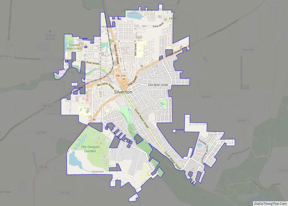
Map of St. Paul city, Oregon

Map of St. Paul city, Oregon

St. Paul is a city in Marion County, Oregon, United States. It is named after the Saint Paul Mission founded by Archbishop François Norbert Blanchet, who arrived in the Oregon Country in 1838 to minister to the Catholic inhabitants of French Prairie. The population was 434 at the 2020 census. The city is part of … Read more

Map of St. Helens city

Map of St. Helens city

St. Helens is the county seat of Columbia County, Oregon. It was founded by Captain Henry Montgomery Knighton, a native of New England, in 1845, as “Plymouth”. The name was changed to St. Helens in the latter part of 1850 for its view of Mount St. Helens, roughly 39 miles (63 km) away in Washington. The … Read more

Map of Takilma CDP

Map of Takilma CDP

Takilma is an unincorporated community and census-designated place (CDP) in Josephine County, Oregon, United States, 10 miles (16 km) south of Cave Junction. It is located on the East Fork Illinois River, about a mile southeast of the ghost town of Waldo. As of the 2010 census, it had a population of 378. Takilma is considered … Read more

Map of Sweet Home city, Oregon

Map of Sweet Home city, Oregon

Sweet Home is a city in Linn County, Oregon, United States, with population 8,925 at the 2010 census. Built near the site of a prehistoric petrified forest, Sweet Home experienced substantial growth during the construction of the Green Peter and Foster dams in the 1940s. The town’s main attraction nowadays is the Cascade mountains through … Read more

Map of Sutherlin city

Map of Sutherlin city

Sutherlin is a city in Douglas County, Oregon, United States. As of the 2010 Census, the population was 7,810, making it the second most populous city in Douglas County. Located off of I-5, nearby features include Cooper Creek Reservoir, Ford’s pond (treated waste water), the Umpqua River, a golf course, and numerous vineyards. The City … Read more

Map of Sunriver CDP

Map of Sunriver CDP

Sunriver is a census-designated place and 3,300-acre (13 km) planned residential and resort community in Deschutes County, Oregon, United States. As of the 2010 census it had a population of 1,393. It is part of the Bend Metropolitan Statistical Area, located on the eastern side of the Deschutes River, about fifteen miles (25 km) south of Bend … Read more

Map of Sumpter city

Map of Sumpter city

Sumpter is a city in Baker County, Oregon, United States. The population was 204 at the 2010 census. Sumpter is named after Fort Sumter by its founders. The name was inspired by a rock as smooth and round as a cannonball, which reminded a local resident of the American Civil War and Fort Sumter. Sumpter … Read more

Map of Summit CDP, Oregon

Map of Summit CDP, Oregon

Summit is an unincorporated community and census-designated place in Benton County, Oregon, United States. At the 2010 census, it had a population of 82. Summit lies on Oregon Route 180 northwest of Blodgett. Summit has an elevation of 718 feet (219 m). Since 1980 Summit is known locally for its small Summit Summer Festival on the … Read more

Map of Summerville town, Oregon

Map of Summerville town, Oregon

Summerville is a city in Union County, Oregon, United States. The population was 135 at the 2010 census. Summerville town overview: Name: Summerville town LSAD Code: 43 LSAD Description: town (suffix) State: Oregon County: Union County Incorporated: 1885 Elevation: 2,705 ft (824 m) Total Area: 0.26 sq mi (0.68 km²) Land Area: 0.26 sq mi (0.68 km²) Water Area: 0.00 sq mi (0.00 km²) Total Population: … Read more

Map of Sublimity city

Map of Sublimity city

Sublimity is a city in Marion County, Oregon, United States. The population was 2,967 at the 2020 census. It is part of the Salem Metropolitan Statistical Area. Sublimity city overview: Name: Sublimity city LSAD Code: 25 LSAD Description: city (suffix) State: Oregon County: Marion County Incorporated: 1903 Elevation: 551 ft (168 m) Total Area: 0.94 sq mi (2.43 km²) Land … Read more

Map of Stayton city

Map of Stayton city

Stayton is a city in Marion County, Oregon, United States, located 12 miles (19 km) southeast of the state capital, Salem, on Oregon Route 22. It is south of Sublimity and east of Aumsville. Located on the North Santiam River, Stayton is a regional agricultural and light manufacturing center. The population was 8,244 at the 2020 … Read more

Map of Stanfield city, Oregon

Map of Stanfield city, Oregon

Stanfield (English: /ˈstænfiːld/) is a city in Umatilla County, Oregon, United States. The population was 2,043 at the 2010 census. It is part of the Pendleton–Hermiston Micropolitan Statistical Area. Stanfield city overview: Name: Stanfield city LSAD Code: 25 LSAD Description: city (suffix) State: Oregon County: Umatilla County Incorporated: 1910 Elevation: 592 ft (180 m) Total Area: 1.73 sq mi … Read more