Map of Wallowa Lake CDP
Wallowa Lake is a census-designated place (CDP) and unincorporated community in Wallowa County, Oregon, United States. It is located on the south end of Wallowa Lake, and is a small community made up of vacation homes, lodging, restaurants, as well as other small businesses. Wallowa Lake CDP overview: Name: Wallowa Lake CDP LSAD Code: 57 ... Read more
Map of Wallowa Lake CDP
Map of Waldport city
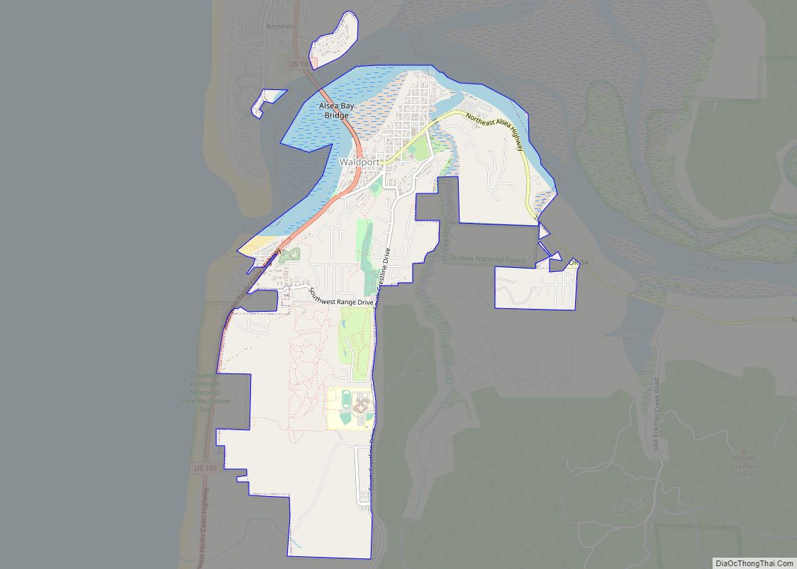
Waldport is a city in Lincoln County, Oregon, United States. The population was 2,033 at the 2010 census. The city is located on the Alsea River and Alsea Bay, 15 miles (24 km) south of Newport and 8 miles (13 km) north of Yachats. Waldport city overview: Name: Waldport city LSAD Code: 25 LSAD Description: city (suffix) ... Read more
Map of Waldport city
Map of Vernonia city
Vernonia is a city in Columbia County, Oregon, United States. It is located on the Nehalem River, in a valley on the eastern side of the Northern Oregon Coast Range that is the heart of one of the most important timber-producing areas of the state. Logging has played a large role in the history of ... Read more
Map of Vernonia city
Map of Veneta city
Veneta is a city in Lane County, Oregon, United States. As of the 2010 census, the city population was 4,561. Veneta city overview: Name: Veneta city LSAD Code: 25 LSAD Description: city (suffix) State: Oregon County: Lane County Incorporated: 1962 Elevation: 418 ft (127.4 m) Total Area: 2.57 sq mi (6.66 km²) Land Area: 2.57 sq mi (6.66 km²) Water Area: 0.00 sq mi (0.00 km²) ... Read more
Map of Veneta city
Map of Vale city, Oregon
Vale is a city in and the county seat of Malheur County, Oregon, United States, about 12 miles (19 km) west of the Idaho border. It is at the intersection of U.S. Routes 20 and 26, on the Malheur River at its confluence with Bully Creek. Vale was selected as Malheur’s county seat in 1888 in ... Read more
Map of Vale city, Oregon
Map of Unity city, Oregon
Unity is a city in Baker County, Oregon, United States, located in the Burnt River Valley. The population was 71 at the 2010 census. Unity city overview: Name: Unity city LSAD Code: 25 LSAD Description: city (suffix) State: Oregon County: Baker County Incorporated: 1972 Elevation: 4,040 ft (1,230 m) Total Area: 0.65 sq mi (1.68 km²) Land Area: 0.64 sq mi (1.66 km²) ... Read more
Map of Unity city, Oregon
Map of West Scio CDP
West Scio is an unincorporated community and census-designated place (CDP) in Linn County, Oregon, United States. It lies at the intersection of Jefferson–Scio Road and West Scio Road about 2 miles (3 km) west of Scio. As of the 2010 census, the population was 120. West Scio CDP overview: Name: West Scio CDP LSAD Code: 57 ... Read more
Map of West Scio CDP
Map of West Linn city
West Linn is a city in Clackamas County, Oregon, United States. A southern suburb within the Portland metropolitan area, West Linn developed on the site of the former Linn City, which was named after U.S. Senator Lewis F. Linn of Ste. Genevieve, Missouri, who had advocated the American occupation of the Oregon territory as a ... Read more
Map of West Linn city
Map of West Haven-Sylvan CDP
West Haven-Sylvan is a census-designated place (CDP) in Washington and Multnomah counties, Oregon, United States, north of U.S. Route 26. As of the 2020 census, the CDP population was 9,299. West Haven-Sylvan CDP overview: Name: West Haven-Sylvan CDP LSAD Code: 57 LSAD Description: CDP (suffix) State: Oregon County: Multnomah County, Washington County Total Area: 2.26 sq mi ... Read more
Map of West Haven-Sylvan CDP
Map of Waterloo town, Oregon
Waterloo is a city in Linn County, Oregon, United States. The population was 229 at the 2010 census. The city’s name, a joking reference to the Battle of Waterloo, stemmed from a 19th-century court decision that settled a land dispute at Kees Mill along the South Santiam River. After the dispute ended, Kees Mill became ... Read more
Map of Waterloo town, Oregon
Map of Wasco city, Oregon
Wasco is a city in Sherman County, Oregon, United States. The population was 410 at the 2010 census. Wasco city overview: Name: Wasco city LSAD Code: 25 LSAD Description: city (suffix) State: Oregon County: Sherman County Incorporated: 1898 Elevation: 1,281 ft (390.4 m) Total Area: 1.01 sq mi (2.61 km²) Land Area: 1.01 sq mi (2.61 km²) Water Area: 0.00 sq mi (0.00 km²) Total Population: ... Read more
Map of Wasco city, Oregon
Map of Warrenton city, Oregon
Warrenton is a small, coastal city in Clatsop County, Oregon, United States. Named for D.K. (Daniel Knight) Warren, an early settler, the town is primarily a fishing and logging community. The population was 6,277 according to the 2020 US Census. Warrenton is a less urbanized area close to the Clatsop County seat, Astoria. Warrenton city ... Read more
Map of Warrenton city, Oregon