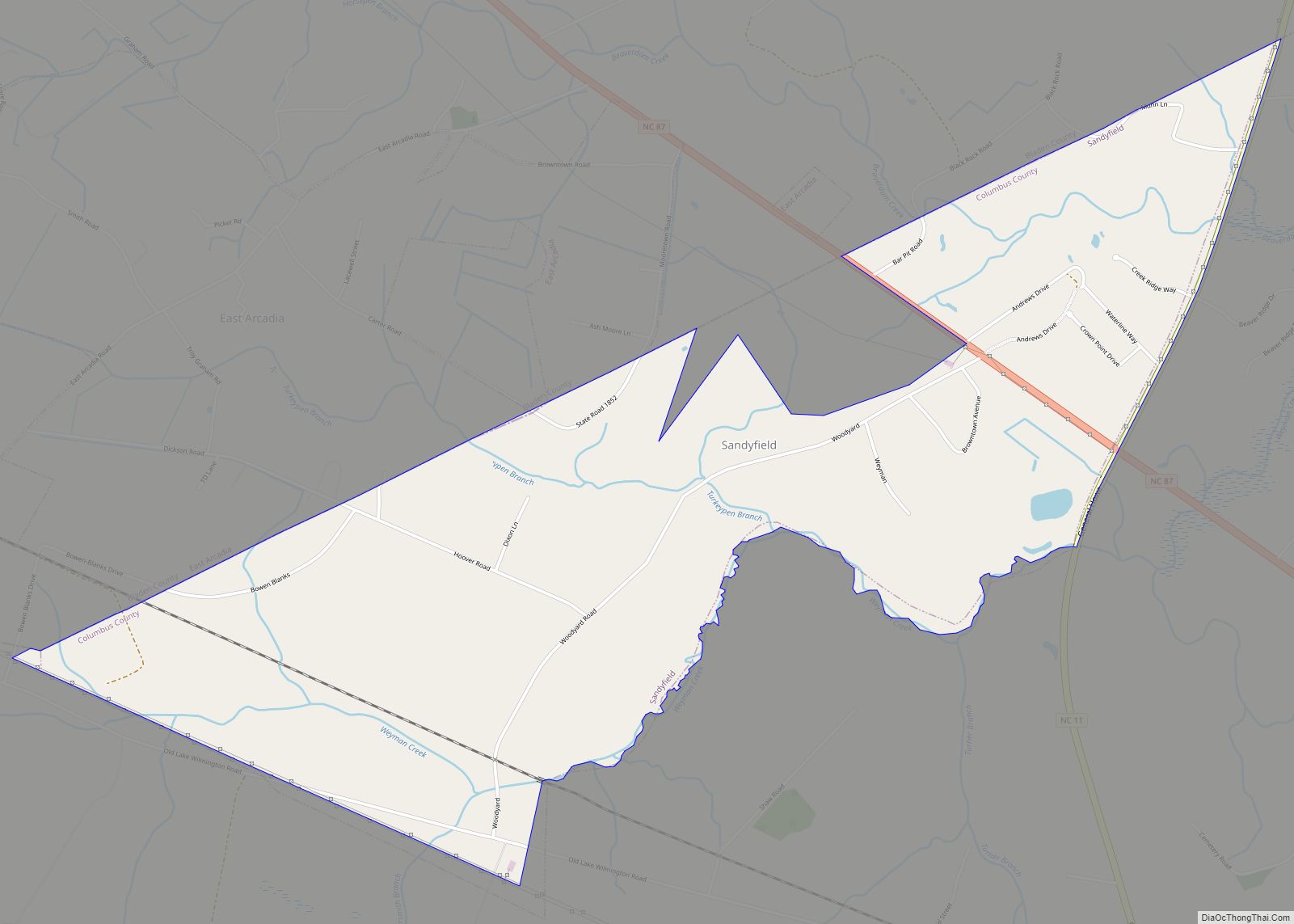
Sandyfield is a town in Columbus County, North Carolina, United States. The population was 447 at the 2010 census. Sandyfield town overview: Name: Sandyfield town LSAD Code: 43 LSAD Description: town (suffix) State: North Carolina County: Columbus County Elevation: 43 ft (13 m) Total Area: 3.09 sq mi (8.00 km²) Land Area: 3.08 sq mi (7.98 km²) Water Area: 0.01 sq mi (0.02 km²) Total Population: ... Read more
Map of US Cities and Places
Sandy Creek is a town in Brunswick County, North Carolina, United States. The population was 260 at the 2010 census. It is part of the Myrtle Beach metropolitan area. Sandy Creek town overview: Name: Sandy Creek town LSAD Code: 43 LSAD Description: town (suffix) State: North Carolina County: Brunswick County Elevation: 39 ft (12 m) Total Area: ... Read more
Salvo is a census-designated place located in Dare County, North Carolina, United States, on Hatteras Island, part of North Carolina’s Outer Banks. As of the 2010 census, Salvo had a population of 229. Originally (with Rodanthe and Waves) part of the settlement of Chicamacomico, Salvo was originally known as “Clarks” or “Clarksville.” The name “Salvo” ... Read more
Saluda is a city in Polk and Henderson counties in the U.S. state of North Carolina. The population was 713 at the 2010 census. Saluda is famous for sitting at the top of the Norfolk Southern Railway’s Saluda Grade, which was the steepest main line standard-gauge railway line in the United States until Norfolk Southern ... Read more
Salisbury is a city in the Piedmont region of North Carolina, United States; it has been the county seat of Rowan County since 1753 when its territory extended to the Mississippi River. Located 25 miles (40 km) northeast of Charlotte and within its metropolitan area, the town has attracted a growing population. The 2020 census shows ... Read more
Salemburg is a town in Sampson County, North Carolina, United States. The population was 435 at the 2010 census. Salemburg is located on N.C. 242 between U.S. Route 421 and N.C. 24, 12 miles west of Clinton, 20 miles west of Interstate 40, 20 miles east of Interstate 95. The town incorporated as Salemburg in 1905. Salemburg town ... Read more
Salem CDP overview: Name: Salem CDP LSAD Code: 57 LSAD Description: CDP (suffix) State: North Carolina County: Burke County FIPS code: 3758740 Online Interactive Map Salem online map. Source: Basemap layers from Google Map, Open Street Map (OSM), Arcgisonline, Wmflabs. Boundary Data from Database of Global Administrative Areas. Salem location map. Where is Salem CDP? ... Read more
Rutherfordton (usually pronounced (/ˈrʌfɪn/ RUFF-in) or (/ˈrʌftʌn/ RUFF-ton), among other similar variations) is a town in Rutherford County, North Carolina, United States. The population was 4,213 at the 2010 census. It is the county seat. Rutherfordton town overview: Name: Rutherfordton town LSAD Code: 43 LSAD Description: town (suffix) State: North Carolina County: Rutherford County Elevation: ... Read more
Rutherford College is a town in Burke County, North Carolina, United States. As of the 2010 census, the town population was 1,341. It is part of the Hickory–Lenoir–Morganton Metropolitan Statistical Area. The town was named for the college that was once located there, Rutherford College, which operated from the 1850s until the 1930s. The campus ... Read more
Sawmills is a town in Caldwell County, North Carolina, United States. As of the 2010 census, the town population was 5,240. It is part of the Hickory–Lenoir–Morganton Metropolitan Statistical Area. The town is named after the timber industry that formerly predominated in the area during its early history. Sawmills town overview: Name: Sawmills town LSAD ... Read more
Saratoga is a town in Wilson County, North Carolina, United States. The population was 408 at the 2010 census. Saratoga town overview: Name: Saratoga town LSAD Code: 43 LSAD Description: town (suffix) State: North Carolina County: Wilson County Elevation: 118 ft (36 m) Total Area: 0.63 sq mi (1.64 km²) Land Area: 0.63 sq mi (1.64 km²) Water Area: 0.00 sq mi (0.00 km²) Total Population: ... Read more
Selma is a town in Johnston County, North Carolina, United States. In 2010, the population was 6,073, and as of 2018 the estimated population was 6,913. Selma is part of the Raleigh-Durham-Cary Combined Statistical Area. The area has a population over 1.7 million residents, though the town of Selma is able to maintain its rural ... Read more