Map of Shallotte town
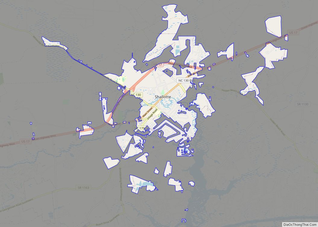
Shallotte (/ʃəˈloʊt/ shə-LOHT) is a town in Brunswick County, North Carolina, United States. The population was 3,675 at the 2010 census. The Shallotte River passes through the town. Shallotte town overview: Name: Shallotte town LSAD Code: 43 LSAD Description: town (suffix) State: North Carolina County: Brunswick County Incorporated: 1899 Total Area: 9.30 sq mi (24.10 km²) Land Area: ... Read more
Map of Shallotte town
Map of Severn town, North Carolina
Severn is a town in Northampton County, North Carolina, United States. The population was 276 at the 2010 census. It is part of the Roanoke Rapids, North Carolina Micropolitan Statistical Area. Severn is the home of Severn Peanut Corporation, the owners of the Hampton Farms brand of roasted peanuts. Severn town overview: Name: Severn town ... Read more
Map of Severn town, North Carolina
Map of Seven Springs town, North Carolina
Seven Springs is a town in Wayne County, North Carolina, United States. It lies next to the Neuse River. The 2012 population was estimated at 111. It is included in the Goldsboro, North Carolina Metropolitan Statistical Area. Seven Springs town overview: Name: Seven Springs town LSAD Code: 43 LSAD Description: town (suffix) State: North Carolina ... Read more
Map of Seven Springs town, North Carolina
Map of Seven Lakes CDP
Seven Lakes is a census-designated place (CDP) in Moore County, North Carolina, United States. It is located approximately 10–15 minutes from the Pinehurst #2, where three U.S. Opens have been held, in 1999, 2005, and 2014. In 2018, the population of the Seven Lakes CDP was 4,404. Seven Lakes CDP overview: Name: Seven Lakes CDP ... Read more
Map of Seven Lakes CDP
Map of Seven Devils town
Seven Devils is a town in Avery and Watauga counties in the U.S. state of North Carolina. The population was 192 at the 2010 census. The town, which is located in the Appalachian Mountains, is best known as the site of a popular wintertime tubing resort known as Hawksnest, which claims it has the largest ... Read more
Map of Seven Devils town
Map of Silver Lake CDP, North Carolina
Silver Lake is a census-designated place in New Hanover County, North Carolina, United States. The population was 5,598 at the 2010 census, down from 5,788 in 2000. It is part of the Wilmington Metropolitan Statistical Area. Silver Lake CDP overview: Name: Silver Lake CDP LSAD Code: 57 LSAD Description: CDP (suffix) State: North Carolina County: ... Read more
Map of Silver Lake CDP, North Carolina
Map of South Rosemary CDP
South Rosemary is an unincorporated area and census-designated place (CDP) in Halifax County, North Carolina, United States. The population was 2,836 at the 2010 census. It is part of the Roanoke Rapids, North Carolina Micropolitan Statistical Area. South Rosemary CDP overview: Name: South Rosemary CDP LSAD Code: 57 LSAD Description: CDP (suffix) State: North Carolina ... Read more
Map of South Rosemary CDP
Map of South Mills CDP
South Mills is an unincorporated community and census-designated place (CDP) in Camden County, North Carolina, United States. Its population was 454 as of the 2010 census. South Mills has a post office with ZIP code 27976, which opened on March 2, 1840. The community is located near U.S. Route 17, and U.S. Route 17 Business ... Read more
Map of South Mills CDP
Map of South Henderson CDP
South Henderson is a census-designated place (CDP) in Vance County, North Carolina, United States. The population was 1,213 at the 2010 census. South Henderson CDP overview: Name: South Henderson CDP LSAD Code: 57 LSAD Description: CDP (suffix) State: North Carolina County: Vance County Elevation: 505 ft (154 m) Total Area: 1.80 sq mi (4.67 km²) Land Area: 1.80 sq mi (4.67 km²) Water ... Read more
Map of South Henderson CDP
Map of Snow Hill town, North Carolina
Snow Hill is a town in Greene County, North Carolina, United States. The population was 1,595 at the 2010 census. It is the county seat of Greene County and is part of the Greenville Metropolitan Area. Snow Hill hosts numerous tennis tournaments during the year. Snow Hill is home to the Green Ridge Racquet Club. ... Read more
Map of Snow Hill town, North Carolina
Map of Sneads Ferry CDP
Sneads Ferry is a census-designated place (CDP) in Onslow County, North Carolina, United States. It is the second largest municipality in Onslow County, behind Jacksonville and is part of the Jacksonville, North Carolina Metropolitan Statistical Area. Once a rural fishing village, Sneads Ferry has experienced a surge in development since 2000. Based on U.S. Census ... Read more
Map of Sneads Ferry CDP
Map of Smithfield town, North Carolina
Smithfield is a town in and the county seat of Johnston County, North Carolina, United States. As of the 2010 census, its population was 10,966, and in 2019 the estimated population was 12,985. Smithfield is home to the Ava Gardner Museum and is situated along the Neuse River, where visitors enjoy the annual Smithfield Ham ... Read more
Map of Smithfield town, North Carolina