Map of Spencer town, North Carolina
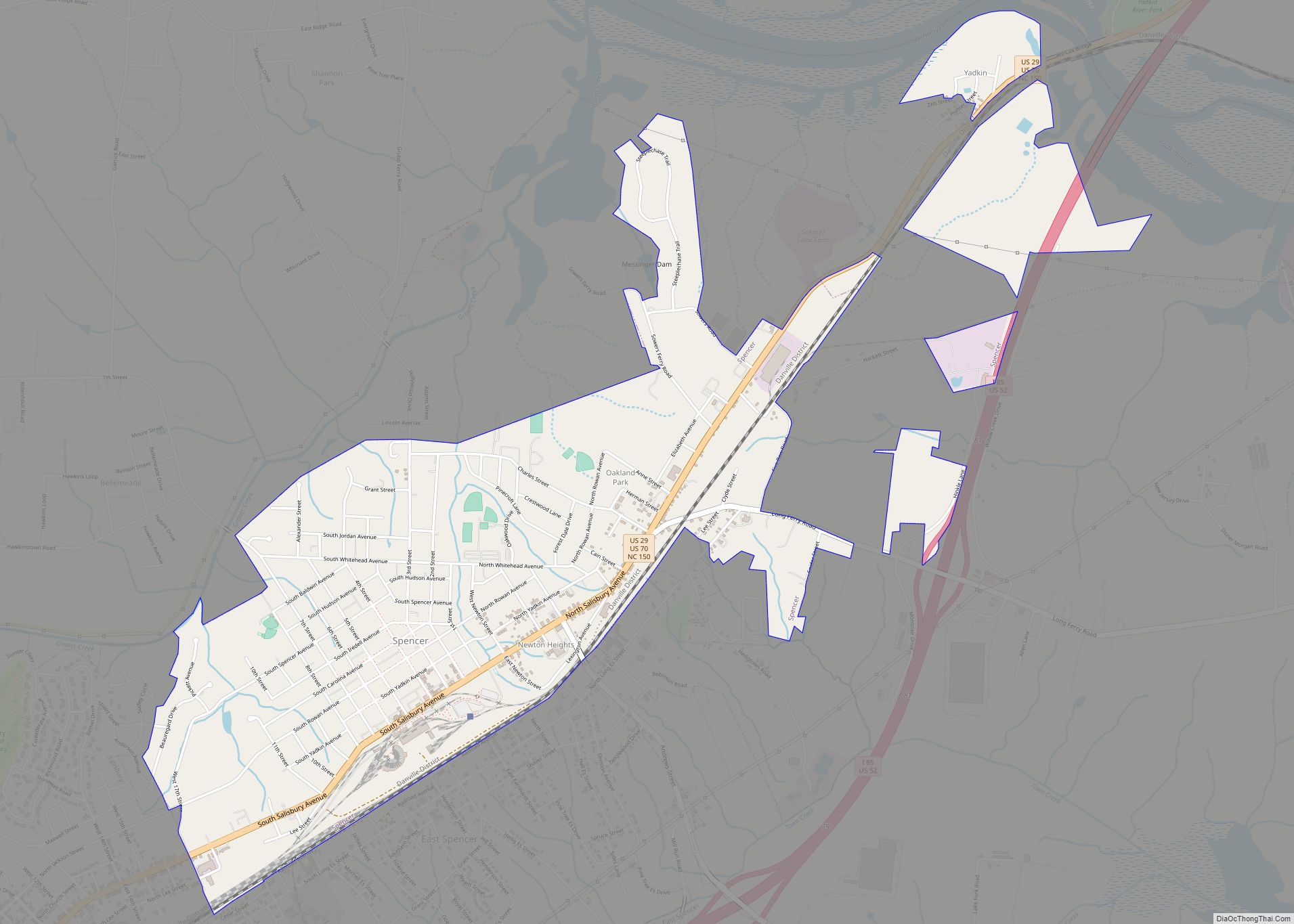
Spencer is a town in Rowan County, North Carolina, United States, incorporated in 1905. As of the 2010 census, the town population was 3,267. Spencer town overview: Name: Spencer town LSAD Code: 43 LSAD Description: town (suffix) State: North Carolina County: Rowan County Elevation: 715 ft (218 m) Total Area: 3.07 sq mi (7.95 km²) Land Area: 3.07 sq mi (7.95 km²) Water ... Read more
Map of Spencer town, North Carolina
Map of Stallings town
Stallings is a suburban town in Union and Mecklenburg counties in the U.S. state of North Carolina. The population was 13,831 at the 2010 census. Stallings town overview: Name: Stallings town LSAD Code: 43 LSAD Description: town (suffix) State: North Carolina County: Mecklenburg County, Union County Elevation: 764 ft (233 m) Total Area: 8.44 sq mi (21.87 km²) Land Area: ... Read more
Map of Stallings town
Map of Staley town
Staley is a town in Randolph County, North Carolina, United States. The population was 393 at the 2010 census. Staley town overview: Name: Staley town LSAD Code: 43 LSAD Description: town (suffix) State: North Carolina County: Randolph County Elevation: 725 ft (221 m) Total Area: 1.16 sq mi (3.00 km²) Land Area: 1.16 sq mi (3.00 km²) Water Area: 0.00 sq mi (0.00 km²) Total Population: ... Read more
Map of Staley town
Map of St. Stephens CDP, North Carolina
St. Stephens CDP overview: Name: St. Stephens CDP LSAD Code: 57 LSAD Description: CDP (suffix) State: North Carolina County: Catawba County FIPS code: 3758730 Online Interactive Map St. Stephens online map. Source: Basemap layers from Google Map, Open Street Map (OSM), Arcgisonline, Wmflabs. Boundary Data from Database of Global Administrative Areas. St. Stephens location map. ... Read more
Map of St. Stephens CDP, North Carolina
Map of St. Pauls town
St. Pauls town overview: Name: St. Pauls town LSAD Code: 43 LSAD Description: town (suffix) State: North Carolina County: Robeson County FIPS code: 3758720 Online Interactive Map St. Pauls online map. Source: Basemap layers from Google Map, Open Street Map (OSM), Arcgisonline, Wmflabs. Boundary Data from Database of Global Administrative Areas. St. Pauls location map. ... Read more
Map of St. Pauls town
Map of St. James town, North Carolina
St. James town overview: Name: St. James town LSAD Code: 43 LSAD Description: town (suffix) State: North Carolina County: Brunswick County FIPS code: 3758630 Online Interactive Map St. James online map. Source: Basemap layers from Google Map, Open Street Map (OSM), Arcgisonline, Wmflabs. Boundary Data from Database of Global Administrative Areas. St. James location map. ... Read more
Map of St. James town, North Carolina
Map of St. Helena village, North Carolina
St. Helena village overview: Name: St. Helena village LSAD Code: 47 LSAD Description: village (suffix) State: North Carolina County: Pender County FIPS code: 3758620 Online Interactive Map St. Helena online map. Source: Basemap layers from Google Map, Open Street Map (OSM), Arcgisonline, Wmflabs. Boundary Data from Database of Global Administrative Areas. St. Helena location map. ... Read more
Map of St. Helena village, North Carolina
Map of Spruce Pine town, North Carolina
Spruce Pine is a town in Mitchell County, North Carolina, United States. The population was 2,175 at the 2010 census. Spruce Pine town overview: Name: Spruce Pine town LSAD Code: 43 LSAD Description: town (suffix) State: North Carolina County: Mitchell County Incorporated: 1907 Elevation: 2,559 ft (780 m) Total Area: 4.68 sq mi (12.13 km²) Land Area: 4.68 sq mi (12.13 km²) Water ... Read more
Map of Spruce Pine town, North Carolina
Map of Spring Lake town, North Carolina
Spring Lake is a town in Cumberland County, North Carolina, United States. The 2010 census recorded the population at 11,964 people, with an estimated population in 2019 of 12,005. Spring Lake town overview: Name: Spring Lake town LSAD Code: 43 LSAD Description: town (suffix) State: North Carolina County: Cumberland County Elevation: 276 ft (84 m) Total Area: ... Read more
Map of Spring Lake town, North Carolina
Map of Spring Hope town
Spring Hope is a town in Nash County, North Carolina, United States. It is part of the Rocky Mount, North Carolina Metropolitan Statistical Area. The population was 1,320 at the 2010 census. Spring Hope town overview: Name: Spring Hope town LSAD Code: 43 LSAD Description: town (suffix) State: North Carolina County: Nash County Elevation: 262 ft ... Read more
Map of Spring Hope town
Map of Spivey’s Corner CDP
Spivey’s Corner is a census-designated place located in Sampson County, North Carolina, United States, at the intersection of U.S. Highway 13 and U.S. Highway 421. As of the 2020 census, the CDP had a total population of 576. From 1969 to 2016, Spivey’s Corner was the home of the National Hollerin’ Contest. Contestants from the ... Read more
Map of Spivey’s Corner CDP
Map of Star town, North Carolina
Star is a town in Montgomery County, North Carolina, United States. The population was 876 at the 2010 census. Star town overview: Name: Star town LSAD Code: 43 LSAD Description: town (suffix) State: North Carolina County: Montgomery County Elevation: 643 ft (196 m) Total Area: 1.29 sq mi (3.35 km²) Land Area: 1.29 sq mi (3.35 km²) Water Area: 0.00 sq mi (0.00 km²) Total Population: ... Read more
Map of Star town, North Carolina