Map of Williamston town, North Carolina
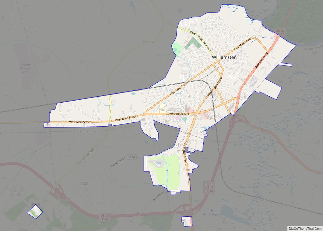
Williamston is a town and the county seat of Martin County, North Carolina, United States. The population was 5,511 at the 2010 census. It is located in North Carolina’s Inner Banks region. The closest major city is Greenville, approximately 28 mi to the southwest. Williamston town overview: Name: Williamston town LSAD Code: 43 LSAD Description: town ... Read more
Map of Williamston town, North Carolina
Map of Wilkesboro town
Wilkesboro is a town in and the county seat of Wilkes County, North Carolina, United States. The population was 3,687 at the 2020 census. The town is located along the south bank of the Yadkin River, directly opposite the town of North Wilkesboro. Wilkesboro is a Small Town Main Street community and has recently revitalized ... Read more
Map of Wilkesboro town
Map of Whitsett town
Whitsett is a town in Guilford County, North Carolina, United States. The population was 590 at the 2010 census. Whitsett town overview: Name: Whitsett town LSAD Code: 43 LSAD Description: town (suffix) State: North Carolina County: Guilford County Elevation: 686 ft (209 m) Total Area: 2.61 sq mi (6.76 km²) Land Area: 2.58 sq mi (6.69 km²) Water Area: 0.03 sq mi (0.07 km²) Total Population: ... Read more
Map of Whitsett town
Map of Abercrombie city
Abercrombie is a city in Richland County, North Dakota, United States. The population was 244 at the 2020 census. Abercrombie was founded in 1884. Abercrombie city overview: Name: Abercrombie city LSAD Code: 25 LSAD Description: city (suffix) State: North Dakota County: Richland County Founded: 1884 Elevation: 938 ft (286 m) Total Area: 0.32 sq mi (0.84 km²) Land Area: 0.32 sq mi ... Read more
Map of Abercrombie city
Map of Zebulon town, North Carolina
Zebulon town overview: Name: Zebulon town LSAD Code: 43 LSAD Description: town (suffix) State: North Carolina County: Johnston County, Wake County FIPS code: 3776220 Online Interactive Map Zebulon online map. Source: Basemap layers from Google Map, Open Street Map (OSM), Arcgisonline, Wmflabs. Boundary Data from Database of Global Administrative Areas. Zebulon location map. Where is ... Read more
Map of Zebulon town, North Carolina
Map of Youngsville town, North Carolina
Youngsville is a town in Franklin County, North Carolina, United States. The population was 2,016 at the 2020 census. Youngsville town overview: Name: Youngsville town LSAD Code: 43 LSAD Description: town (suffix) State: North Carolina County: Franklin County Incorporated: March 17, 1875 Elevation: 462 ft (141 m) Total Area: 1.86 sq mi (4.82 km²) Land Area: 1.85 sq mi (4.80 km²) Water Area: ... Read more
Map of Youngsville town, North Carolina
Map of Yanceyville town
Yanceyville is a town in and the county seat of Caswell County, North Carolina, United States. Located in the Piedmont Triad region of the state, the town had a population of 1,937 at the 2020 census. The settlement was founded in 1792 and was later named Yanceyville in honor of U.S. Congressman Bartlett Yancey, Jr. ... Read more
Map of Yanceyville town
Map of Yadkinville town
Yadkinville is a town in Yadkin County, North Carolina, United States. The population was 2,995 at the 2020 census. Located in the Piedmont Triad, it is the county seat and largest city of Yadkin County. Yadkinville town overview: Name: Yadkinville town LSAD Code: 43 LSAD Description: town (suffix) State: North Carolina County: Yadkin County Elevation: ... Read more
Map of Yadkinville town
Map of Wrightsville Beach town
Wrightsville Beach is a town in New Hanover County, North Carolina, United States. Wrightsville Beach is just east of Wilmington and is part of the Wilmington Metropolitan Statistical Area. The population was 2,477 at the 2010 census. The town consists of a 4-mile (6 km) long beach island, an interior island called Harbor Island, and pockets ... Read more
Map of Wrightsville Beach town
Map of Wrightsboro CDP
Wrightsboro is a census-designated place (CDP) in New Hanover County, North Carolina, United States. At the 2010 census, the population was 4,896, up from 4,496 in 2000. It is part of the Wilmington Metropolitan Statistical Area. Wrightsboro CDP overview: Name: Wrightsboro CDP LSAD Code: 57 LSAD Description: CDP (suffix) State: North Carolina County: New Hanover ... Read more
Map of Wrightsboro CDP
Map of Woodlawn CDP, North Carolina
Woodlawn is a census-designated place in Alamance County, North Carolina, United States. Woodlawn CDP overview: Name: Woodlawn CDP LSAD Code: 57 LSAD Description: CDP (suffix) State: North Carolina County: Alamance County Elevation: 607 ft (185 m) Total Area: 3.57 sq mi (9.24 km²) Land Area: 3.29 sq mi (8.53 km²) Water Area: 0.28 sq mi (0.71 km²) Total Population: 912 Population Density: 276.87/sq mi (106.90/km²) ZIP code: ... Read more
Map of Woodlawn CDP, North Carolina
Map of Woodland town, North Carolina
Woodland is a town in Northampton County, North Carolina, United States. The population was 809 at the 2010 census. It is part of the Roanoke Rapids, North Carolina Micropolitan Statistical Area. Woodland town overview: Name: Woodland town LSAD Code: 43 LSAD Description: town (suffix) State: North Carolina County: Northampton County Elevation: 69 ft (21 m) Total Area: ... Read more
Map of Woodland town, North Carolina