Map of St. Thomas city, North Dakota
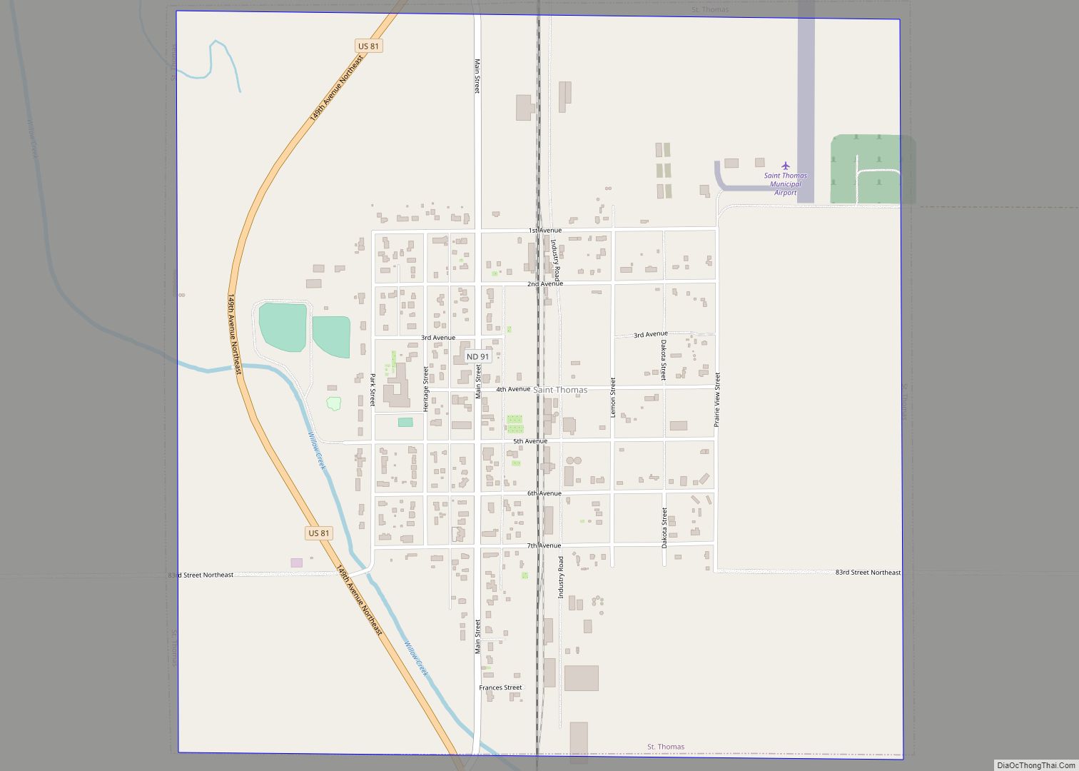
St. Thomas is a city in Pembina County, North Dakota, United States. The population was 323 at the 2020 census. The city, located in the Red River Valley region. St. Thomas city overview: Name: St. Thomas city LSAD Code: 25 LSAD Description: city (suffix) State: North Dakota County: Pembina County Founded: 1881 Elevation: 840 ft (256 m) ... Read more
Map of St. Thomas city, North Dakota
Map of St. John city, North Dakota
St. John is a city in Rolette County, North Dakota, United States. The population was 322 at the 2020 census. St. John city overview: Name: St. John city LSAD Code: 25 LSAD Description: city (suffix) State: North Dakota County: Rolette County Founded: 1882 Elevation: 1,949 ft (594 m) Total Area: 0.44 sq mi (1.14 km²) Land Area: 0.44 sq mi (1.14 km²) Water ... Read more
Map of St. John city, North Dakota
Map of Springbrook city, North Dakota
Springbrook is a city in Williams County, North Dakota, United States. The population was 37 at the 2020 census. It is also spelled Spring Brook. Springbrook city overview: Name: Springbrook city LSAD Code: 25 LSAD Description: city (suffix) State: North Dakota County: Williams County Elevation: 2,070 ft (631 m) Total Area: 0.37 sq mi (0.97 km²) Land Area: 0.37 sq mi (0.97 km²) ... Read more
Map of Springbrook city, North Dakota
Map of Spiritwood CDP
Spiritwood is a census-designated place (CDP) in eastern Stutsman County, North Dakota, United States. An unincorporated community, it was designated as part of the U.S. Census Bureau’s Participant Statistical Areas Program on March 31, 2010. It was not counted separately during the 2000 census, but was included in the 2010 census, where a population of ... Read more
Map of Spiritwood CDP
Map of Surrey city
Surrey is a town in Ward County, North Dakota, United States. The population was 1,357 at the 2020 census. Official incorporation of Surrey occurred in 1951. The city is part of the Minot Micropolitan Statistical Area. Surrey city overview: Name: Surrey city LSAD Code: 25 LSAD Description: city (suffix) State: North Dakota County: Ward County ... Read more
Map of Surrey city
Map of Tower City, North Dakota
Tower City is a city in Barnes and Cass counties in the State of North Dakota. The population was 268 at the 2020 census. Tower City city overview: Name: Tower City city LSAD Code: 25 LSAD Description: city (suffix) State: North Dakota County: Barnes County, Cass County Elevation: 1,171 ft (357 m) Total Area: 2.05 sq mi (5.31 km²) Land ... Read more
Map of Tower City, North Dakota
Map of Tolna city
Tolna is a city in Nelson County, North Dakota, United States. The population was 136 at the 2020 census. Tolna was founded in 1906. In February 2019, resident Brian Nelson, who is an antique collector, was featured on “American Pickers” on the History Channel. Tolna city overview: Name: Tolna city LSAD Code: 25 LSAD Description: ... Read more
Map of Tolna city
Map of Tolley city
Tolley is a city in Renville County, North Dakota, United States. The population was 41 at the 2020 census. It is part of the Minot Micropolitan Statistical Area. Tolley was founded by Eli Crane Tolley in 1905. Mr. Tolley was born in Darlington, Wisconsin in 1860 to parents William Tolley and Frances G. (Crane) Tolley. ... Read more
Map of Tolley city
Map of Tioga city, North Dakota
Tioga (/taɪˈoʊɡə/ ty-OH-gə) is a city in Williams County, North Dakota, United States. The population was 2,202 at the 2020 census. Tioga was founded in 1902 and named by settlers from Tioga, New York. The population of the city increased dramatically in the 1950s following the discovery of oil nearby in the Williston Basin. Tioga ... Read more
Map of Tioga city, North Dakota
Map of Thompson city, North Dakota
Thompson is a city in Grand Forks County, North Dakota, United States. It is part of the “Grand Forks, ND–MN Metropolitan Statistical Area” or “Greater Grand Forks”. It is located on the border of Allendale and Walle townships, with Walle on the east and Allendale on the west. The population was 1,101 at the 2020 ... Read more
Map of Thompson city, North Dakota
Map of Taylor city, North Dakota
Taylor is a city in Stark County, North Dakota, United States. The population was 230 at the 2020 census. It is part of the Dickinson Micropolitan Statistical Area. Taylor city overview: Name: Taylor city LSAD Code: 25 LSAD Description: city (suffix) State: North Dakota County: Stark County Elevation: 2,500 ft (762 m) Total Area: 0.51 sq mi (1.31 km²) Land ... Read more
Map of Taylor city, North Dakota
Map of Tappen city
Tappen is a city in Kidder County, North Dakota, United States. The population was 217 at the 2020 census. Tappen city overview: Name: Tappen city LSAD Code: 25 LSAD Description: city (suffix) State: North Dakota County: Kidder County Elevation: 1,772 ft (540 m) Total Area: 1.05 sq mi (2.72 km²) Land Area: 1.05 sq mi (2.72 km²) Water Area: 0.00 sq mi (0.00 km²) Total Population: ... Read more
Map of Tappen city