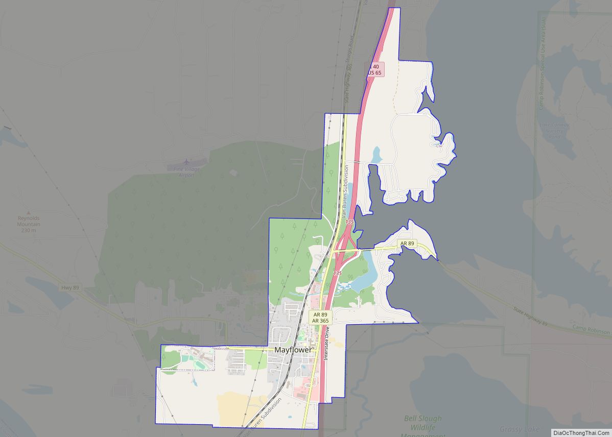
Mayflower is a city in Faulkner County, Arkansas, United States. The population was 2,234 at the 2010 census, up from 1,631 at the 2000 census. Mayflower city overview: Name: Mayflower city LSAD Code: 25 LSAD Description: city (suffix) State: Arkansas County: Faulkner County Elevation: 282 ft (86 m) Total Area: 4.05 sq mi (10.50 km²) Land Area: 3.94 sq mi (10.20 km²) Water ... Read more
Map of US Cities and Places
Maumelle is a city in Pulaski County, Arkansas, United States. As of the 2020 census, the city’s population was 19,251. The city is located northwest of Little Rock, bordering the opposite shore of the Arkansas River and is part of the Little Rock metropolitan area. Maumelle city overview: Name: Maumelle city LSAD Code: 25 LSAD ... Read more
Marvell is a city in Phillips County, Arkansas, United States. As of the 2010 census, the city population was 1,186. Marvell city overview: Name: Marvell city LSAD Code: 25 LSAD Description: city (suffix) State: Arkansas County: Phillips County Elevation: 210 ft (60 m) Total Area: 1.44 sq mi (3.72 km²) Land Area: 1.44 sq mi (3.72 km²) Water Area: 0.00 sq mi (0.00 km²) Total Population: ... Read more
McAlmont, also referred to as “Mac Side”, is a census-designated place (CDP) in Pulaski County, Arkansas, United States. The population was 1,873 at the 2010 census. The community adjoins eastern North Little Rock, and is part of the Little Rock–North Little Rock–Conway Metropolitan Statistical Area. McAlmont CDP overview: Name: McAlmont CDP LSAD Code: 57 LSAD ... Read more
Maysville is an unincorporated community and census-designated place (CDP) in Benton County, Arkansas, United States. It is the westernmost settlement in the state of Arkansas. Per the 2020 census, the population was 117. It is located in the Northwest Arkansas region. Maysville CDP overview: Name: Maysville CDP LSAD Code: 57 LSAD Description: CDP (suffix) State: ... Read more
Maynard is a town in Randolph County, Arkansas, United States. The population was 379 at the 2020 census. Maynard is home to the Maynard Pioneer Museum and Park. A jail built in 1936 has a door made of wagon wheel rims. The last time it was used was in 1988, when it temporarily housed a ... Read more
McDougal is a city in Clay County, Arkansas, United States. The population was 186 at the 2010 census. McDougal town overview: Name: McDougal town LSAD Code: 43 LSAD Description: town (suffix) State: Arkansas County: Clay County Elevation: 302 ft (92 m) Total Area: 0.37 sq mi (0.96 km²) Land Area: 0.37 sq mi (0.96 km²) Water Area: 0.00 sq mi (0.00 km²) Total Population: 134 Population ... Read more
McCrory is a city in Woodruff County, Arkansas, United States. The population was 1,583 at the 2020 census. The McCrory Commercial Historic District, the McCrory Waterworks, and the Dr. John William Morris Clinic are all listed on the National Register of Historic Places listings in Woodruff County, Arkansas. McCrory city overview: Name: McCrory city LSAD ... Read more
McCaskill is a town in Hempstead County, Arkansas, United States. The population was 96 at the 2010 census. It is part of the Hope Micropolitan Statistical Area. McCaskill town overview: Name: McCaskill town LSAD Code: 43 LSAD Description: town (suffix) State: Arkansas County: Hempstead County Elevation: 446 ft (136 m) Total Area: 0.74 sq mi (1.92 km²) Land Area: 0.74 sq mi ... Read more
McNeil is a town in Columbia County, Arkansas, United States. The population was 516 at the 2010 census, down from 662 in 2000. The community was named after William B. McNeil, founder of the College Hill Academy. McNeil city overview: Name: McNeil city LSAD Code: 25 LSAD Description: city (suffix) State: Arkansas County: Columbia County ... Read more
McNab is a town in Hempstead County, Arkansas, United States. The population was 68 at the 2010 census, up from 37 in 2000. It is part of the Hope Micropolitan Statistical Area. McNab town overview: Name: McNab town LSAD Code: 43 LSAD Description: town (suffix) State: Arkansas County: Hempstead County Elevation: 318 ft (97 m) Total Area: ... Read more
McGehee /məˈɡiː/ mə-GHEE is a city in Desha County, Arkansas, United States. The population was 4,219 at the 2010 census. McGehee city overview: Name: McGehee city LSAD Code: 25 LSAD Description: city (suffix) State: Arkansas County: Desha County Elevation: 144 ft (44 m) Total Area: 6.71 sq mi (17.37 km²) Land Area: 6.71 sq mi (17.37 km²) Water Area: 0.00 sq mi (0.00 km²) Total Population: ... Read more