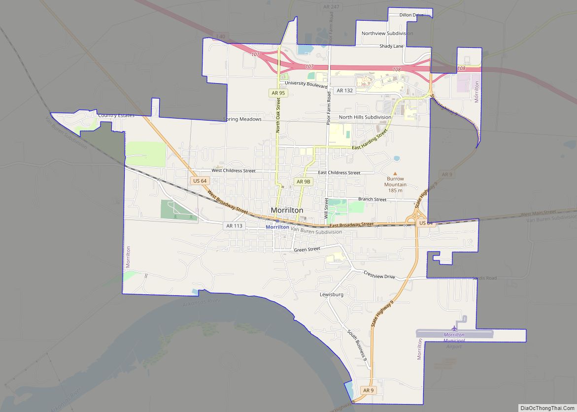
Map of Moro town, Arkansas
Moro is a town in Lee County, Arkansas, United States. The population was 216 at the 2010 census. Moro town overview: Name: Moro town LSAD Code: 43 LSAD Description: town (suffix) State: Arkansas County: Lee County Elevation: 200 ft (60 m) Total Area: 0.96 sq mi (2.50 km²) Land Area: 0.96 sq mi (2.50 km²) Water Area: 0.00 sq mi (0.00 km²) Total Population: 177 Population ... Read more
Map of Moro town, Arkansas
Map of Moorefield town, Arkansas
Moorefield is a town in Independence County, Arkansas, United States. It was named after Jesse A. Moore who owned most of the land in the area of the town at that time. The population was 137 at the 2010 census. Moorefield town overview: Name: Moorefield town LSAD Code: 43 LSAD Description: town (suffix) State: Arkansas ... Read more
Map of Moorefield town, Arkansas
Map of Mount Pleasant town, Arkansas
Mount Pleasant is a town in Izard County, Arkansas, United States. As of the 2020 census, the town population was 353. Mount Pleasant town overview: Name: Mount Pleasant town LSAD Code: 43 LSAD Description: town (suffix) State: Arkansas County: Izard County Elevation: 686 ft (209 m) Total Area: 3.52 sq mi (9.11 km²) Land Area: 3.50 sq mi (9.07 km²) Water Area: 0.01 sq mi ... Read more
Map of Mount Pleasant town, Arkansas
Map of Mount Ida city
Mount Ida is a city in and county seat of Montgomery County, Arkansas, United States. Founded in 1842, the city saw a silver boom in the 1880s bring early prosperity and economic development to the area. Today, the economy is largely ranching, poultry farming, silviculture, and tourism around Lake Ouachita. It is known as the ... Read more
Map of Mount Ida city
Map of Morrison Bluff town
Morrison Bluff is a town in Logan County, Arkansas, United States. The population was 64 at the 2010 census and an estimated 81 in 2017. Morrison Bluff town overview: Name: Morrison Bluff town LSAD Code: 43 LSAD Description: town (suffix) State: Arkansas County: Logan County Elevation: 381 ft (116 m) Total Area: 1.35 sq mi (3.51 km²) Land Area: 1.34 sq mi ... Read more
Map of Morrison Bluff town
Map of Mountain Pine city
Mountain Pine is a city in Garland County, Arkansas, United States. It is part of the Hot Springs Metropolitan Statistical Area. The population was 770 at the 2010 United States Census. It is located immediately southeast of Lake Ouachita below the Blakely Mountain Dam. The city consists of five defined neighborhoods, Pinewood (north), South Mountain ... Read more
Map of Mountain Pine city
Map of Mountain Home city, Arkansas
Mountain Home is a city in Arkansas, and the county seat of, Baxter County, Arkansas, United States, in the southern Ozark Mountains near the northern state border with Missouri. As of the 2010 census, the city had a population of 12,448. A total of 41,307 persons lived within the city and micropolitan area combined, which ... Read more
Map of Mountain Home city, Arkansas
Map of Mount Vernon town, Arkansas
Mount Vernon is a town in Faulkner County, Arkansas, United States. The population was 145 at the 2010 census. It is part of the Little Rock–North Little Rock–Conway Metropolitan Statistical Area. Mount Vernon town overview: Name: Mount Vernon town LSAD Code: 43 LSAD Description: town (suffix) State: Arkansas County: Faulkner County Elevation: 423 ft (129 m) Total ... Read more
Map of Mount Vernon town, Arkansas
Map of Mountainburg city
Mountainburg is a town in Crawford County, Arkansas, United States. It is part of the Fort Smith, Arkansas–Oklahoma Metropolitan Statistical Area. As of the 2010 census the population was 631. Mountainburg was laid out in 1883 when the St. Louis–San Francisco Railway was extended to that point. Mountainburg city overview: Name: Mountainburg city LSAD Code: ... Read more
Map of Mountainburg city
Map of Mountain View city, Arkansas
Mountain View is the largest city in and the county seat of Stone County, Arkansas, United States, located in the Ozarks. The city’s economy is largely based on tourism related to its title as the “Folk Music Capital of the World”. The city is also known for outdoors recreation opportunities, including Blanchard Springs Caverns, trout ... Read more
Map of Mountain View city, Arkansas
Map of Mulberry city, Arkansas
Mulberry is a city in Crawford County, Arkansas, United States. It is part of the Fort Smith, Arkansas–Oklahoma Metropolitan Statistical Area. The population was 1,655 as of the 2010 Census, an increase of 1.72% from 1,627 in 2000. Mulberry city overview: Name: Mulberry city LSAD Code: 25 LSAD Description: city (suffix) State: Arkansas County: Crawford ... Read more
Map of Mulberry city, Arkansas
Map of Natural Steps CDP
Natural Steps is an unincorporated census-designated place in Pulaski County, Arkansas, United States. It is located 18 miles (29 km) northwest of Little Rock along the southern bank of the Arkansas River, on Arkansas Highway 300. Per the 2020 census, the population was 413. Today, it is a small farming community with scattered businesses. Most of ... Read more
Map of Natural Steps CDP