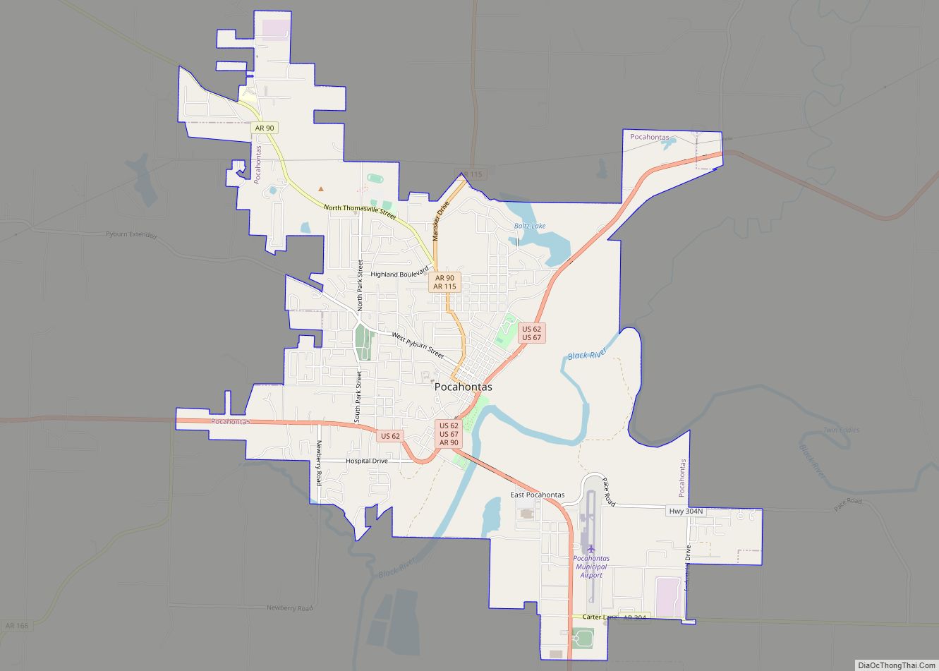
Map of Plumerville city
Plumerville is a city in Conway County, Arkansas, United States. The population was 826 at the 2010 census. Plumerville city overview: Name: Plumerville city LSAD Code: 25 LSAD Description: city (suffix) State: Arkansas County: Conway County Elevation: 315 ft (96 m) Total Area: 1.04 sq mi (2.70 km²) Land Area: 1.03 sq mi (2.67 km²) Water Area: 0.01 sq mi (0.04 km²) Total Population: 734 Population ... Read more
Map of Plumerville city
Map of Pleasant Plains town, Arkansas
Pleasant Plains is a town in Independence County, Arkansas, United States. The population was 349 at the 2010 census, up from 267 in 2000. Pleasant Plains town overview: Name: Pleasant Plains town LSAD Code: 43 LSAD Description: town (suffix) State: Arkansas County: Independence County Elevation: 597 ft (182 m) Total Area: 1.01 sq mi (2.61 km²) Land Area: 1.01 sq mi (2.61 km²) ... Read more
Map of Pleasant Plains town, Arkansas
Map of Portland city, Arkansas
Portland is a town in Ashley County, Arkansas, United States. The population was 430 at the 2010 census. Portland was first settled in the 1830s, and named for its early status as a steamboat port. It was incorporated in 1893. Portland city overview: Name: Portland city LSAD Code: 25 LSAD Description: city (suffix) State: Arkansas ... Read more
Map of Portland city, Arkansas
Map of Portia town
Portia is a town in Lawrence County, Arkansas, United States. The population was 437 at the 2010 census. Portia town overview: Name: Portia town LSAD Code: 43 LSAD Description: town (suffix) State: Arkansas County: Lawrence County Elevation: 262 ft (80 m) Total Area: 1.29 sq mi (3.35 km²) Land Area: 1.29 sq mi (3.35 km²) Water Area: 0.00 sq mi (0.00 km²) Total Population: 424 Population ... Read more
Map of Portia town
Map of Pollard city, Arkansas
Pollard is a city in Clay County, Arkansas, United States. The population was 222 at the 2010 census. Pollard city overview: Name: Pollard city LSAD Code: 25 LSAD Description: city (suffix) State: Arkansas County: Clay County Elevation: 338 ft (103 m) Total Area: 0.30 sq mi (0.77 km²) Land Area: 0.30 sq mi (0.77 km²) Water Area: 0.00 sq mi (0.00 km²) Total Population: 193 Population ... Read more
Map of Pollard city, Arkansas
Map of Poyen town
Poyen is a town in Grant County, Arkansas, United States. The population was 290 at the 2010 census. It is part of the Central Arkansas region. Poyen town overview: Name: Poyen town LSAD Code: 43 LSAD Description: town (suffix) State: Arkansas County: Grant County Elevation: 230 ft (70 m) Total Area: 0.31 sq mi (0.79 km²) Land Area: 0.31 sq mi (0.79 km²) ... Read more
Map of Poyen town
Map of Powhatan town, Arkansas
Powhatan is a town in Lawrence County, Arkansas, United States, along the Black River. The population was 72 at the 2010 census, up from 50 at the 2000 census. Powhatan town overview: Name: Powhatan town LSAD Code: 43 LSAD Description: town (suffix) State: Arkansas County: Lawrence County Elevation: 285 ft (87 m) Total Area: 0.55 sq mi (1.42 km²) Land ... Read more
Map of Powhatan town, Arkansas
Map of Pottsville city, Arkansas
Pottsville is a city in Pope County, Arkansas, United States. As of the 2020 census the population was 3,140. It is part of the Russellville Micropolitan Statistical Area. Pottsville city overview: Name: Pottsville city LSAD Code: 25 LSAD Description: city (suffix) State: Arkansas County: Pope County Elevation: 387 ft (118 m) Total Area: 13.56 sq mi (35.11 km²) Land Area: ... Read more
Map of Pottsville city, Arkansas
Map of Prattsville town, Arkansas
Prattsville is a city in Grant County, Arkansas, United States. The population was 305 at the 2010 census. It is part of the Central Arkansas region. Prattsville town overview: Name: Prattsville town LSAD Code: 43 LSAD Description: town (suffix) State: Arkansas County: Grant County Elevation: 299 ft (91 m) Total Area: 1.62 sq mi (4.21 km²) Land Area: 1.62 sq mi (4.19 km²) ... Read more
Map of Prattsville town, Arkansas
Map of Prairie Grove city, Arkansas
Prairie Grove is a city in Washington County, Arkansas, United States. The population was 7,045 at the 2020 Census. It is part of the Northwest Arkansas region, and home to Prairie Grove Battlefield State Park. Prairie Grove city overview: Name: Prairie Grove city LSAD Code: 25 LSAD Description: city (suffix) State: Arkansas County: Washington County ... Read more
Map of Prairie Grove city, Arkansas
Map of Prairie Creek CDP
Prairie Creek is a census-designated place (CDP) in Benton County, Arkansas, United States. Per the 2020 census, the population was 2,217. It is a lakefront community adjacent to Beaver Lake and Rogers within the Northwest Arkansas region. Prairie Creek CDP overview: Name: Prairie Creek CDP LSAD Code: 57 LSAD Description: CDP (suffix) State: Arkansas County: ... Read more
Map of Prairie Creek CDP
Map of Prescott city, Arkansas
Prescott is a city and the county seat of Nevada County, Arkansas, United States. The community had a population of 3,296 at the 2010 census. Prescott is part of the Hope Micropolitan Statistical Area. Located 100 miles southwest of Little Rock, Prescott was developed on the Prairie D’Âne, named by French colonists before the United ... Read more
Map of Prescott city, Arkansas