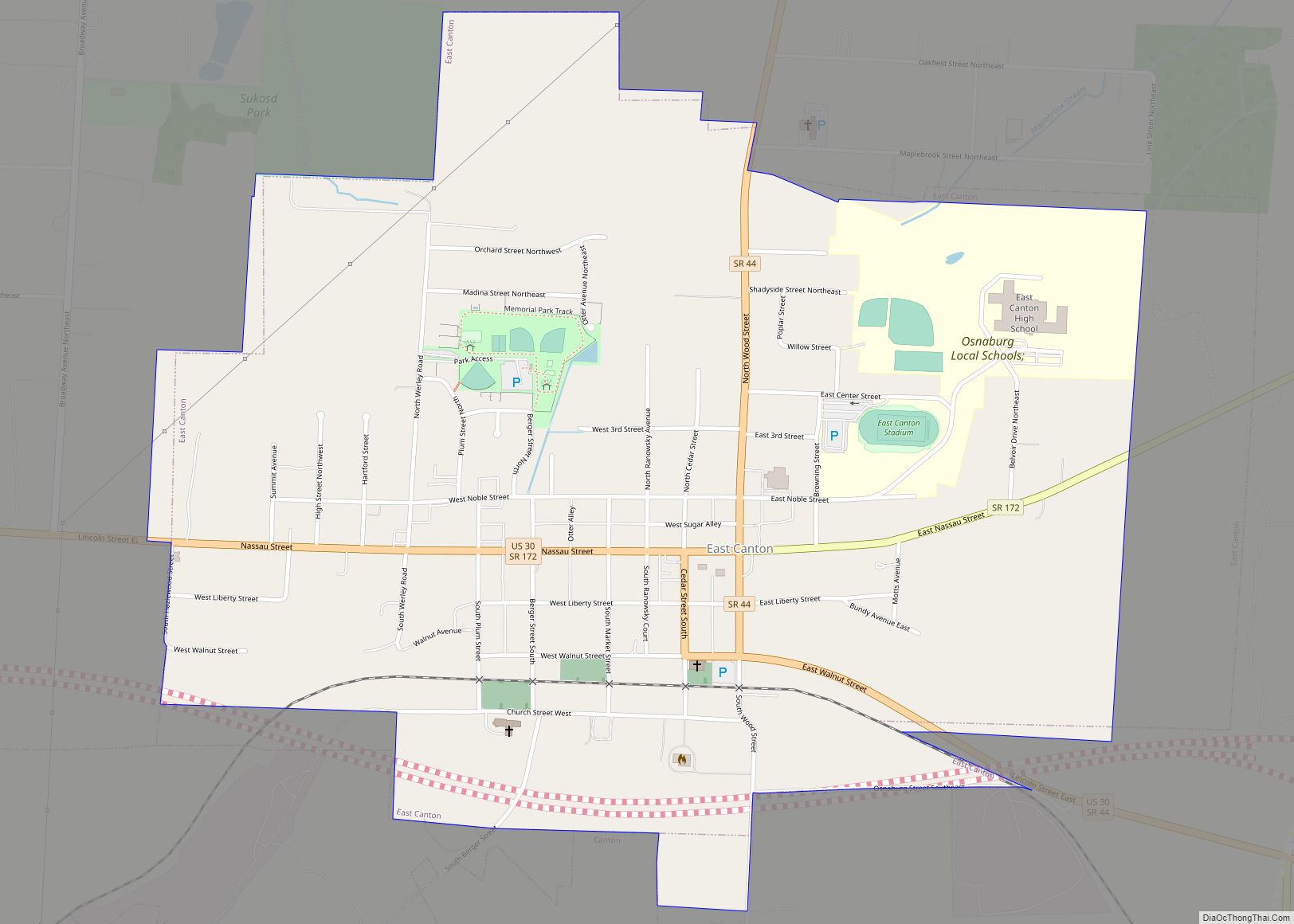
Map of Dupont village, Ohio
Dupont is a village in Putnam County, Ohio, United States. The population was 318 at the 2010 census. Dupont village overview: Name: Dupont village LSAD Code: 47 LSAD Description: village (suffix) State: Ohio County: Putnam County Elevation: 725 ft (221 m) Total Area: 0.92 sq mi (2.37 km²) Land Area: 0.91 sq mi (2.36 km²) Water Area: 0.00 sq mi (0.01 km²) Total Population: 212 Population ... Read more
Map of Dupont village, Ohio
Map of Dunlap CDP, Ohio
Dunlap is a census-designated place (CDP) in Colerain Township, Hamilton County, Ohio, United States. The population was 1,658 at the 2020 census. The siege of Dunlap’s Station was a battle that took place near here on the Great Miami in 1791 during the Northwest Indian War. Dunlap CDP overview: Name: Dunlap CDP LSAD Code: 57 ... Read more
Map of Dunlap CDP, Ohio
Map of Dunkirk village, Ohio
Dunkirk is a village in Hardin County, Ohio, United States. The population was 875 at the 2010 census. Dunkirk village overview: Name: Dunkirk village LSAD Code: 47 LSAD Description: village (suffix) State: Ohio County: Hardin County Elevation: 945 ft (288 m) Total Area: 0.72 sq mi (1.86 km²) Land Area: 0.66 sq mi (1.70 km²) Water Area: 0.06 sq mi (0.15 km²) Total Population: 774 Population ... Read more
Map of Dunkirk village, Ohio
Map of Dundee CDP, Ohio
Dundee is a census-designated place in central Wayne Township, Tuscarawas County, Ohio, United States. It has a post office with the ZIP code 44624. It lies at the intersection of State Routes 93 and 516. Dundee CDP overview: Name: Dundee CDP LSAD Code: 57 LSAD Description: CDP (suffix) State: Ohio County: Tuscarawas County FIPS code: ... Read more
Map of Dundee CDP, Ohio
Map of Duncan Falls CDP
Duncan Falls is a census-designated place in southeastern Wayne Township, Muskingum County, Ohio, United States, located on State Route 60 south of the city of Zanesville. It has a post office with the ZIP code 43734. Duncan Falls has a public library, a branch of the Muskingum County Library System. Duncan Falls CDP overview: Name: ... Read more
Map of Duncan Falls CDP
Map of Dublin city, Ohio
Dublin is a city in Franklin, Delaware and Union counties in the U.S. state of Ohio. The population was 49,328 at the 2020 census. It is a suburb of Columbus. The city of Dublin hosts the yearly Memorial Tournament at the Muirfield Village Golf Club. The Dublin Irish Festival (called Dublin Irish Days in 2021) ... Read more
Map of Dublin city, Ohio
Map of Dry Run CDP
Dry Run is a census-designated place (CDP) in Hamilton County, Ohio, United States. The population was 7,672 at the 2020 census. Dry Run CDP overview: Name: Dry Run CDP LSAD Code: 57 LSAD Description: CDP (suffix) State: Ohio County: Hamilton County Elevation: 873 ft (266 m) Total Area: 4.77 sq mi (12.34 km²) Land Area: 4.76 sq mi (12.32 km²) Water Area: 0.01 sq mi ... Read more
Map of Dry Run CDP
Map of Dry Ridge CDP, Ohio
Dry Ridge is a census-designated place (CDP) in Colerain Township, Hamilton County, Ohio, United States. The population was 2,698 at the 2020 census. Dry Ridge CDP overview: Name: Dry Ridge CDP LSAD Code: 57 LSAD Description: CDP (suffix) State: Ohio County: Hamilton County Elevation: 923 ft (281 m) Total Area: 4.15 sq mi (10.76 km²) Land Area: 4.13 sq mi (10.68 km²) Water ... Read more
Map of Dry Ridge CDP, Ohio
Map of East Rochester CDP, Ohio
East Rochester is an unincorporated community and census-designated place (CDP) in southern West Township, Columbiana County, Ohio, United States. The population was 224 as of the 2020 census. It lies along U.S. Route 30, and has a post office with the ZIP code 44625. It is part of the Salem micropolitan area and the greater ... Read more
Map of East Rochester CDP, Ohio
Map of East Palestine village
East Palestine (/ˌpæləˈstiːn/ PAL-ə-STEEN) is a village in northeastern Columbiana County, Ohio, United States. The population was 4,761 at the 2020 census. Located on the state’s border with Pennsylvania, East Palestine is about 20 miles (32 km) south of Youngstown and 40 miles (64 km) northwest of Pittsburgh. It is part of the Salem micropolitan area. The ... Read more
Map of East Palestine village
Map of East Liverpool city
East Liverpool is a city in southeastern Columbiana County, Ohio, United States. The population was 9,958 at the 2020 census. It lies along the Ohio River within the Upper Ohio Valley and borders Pennsylvania to the east and West Virginia to the south. East Liverpool is included in the Salem micropolitan area, about 34 miles ... Read more
Map of East Liverpool city
Map of East Liberty CDP
East Liberty is an unincorporated community and census-designated place (CDP) located in Perry Township, Logan County, Ohio, United States. As of the 2010 census, it had a population of 366. It is located just off U.S. Route 33, 10 miles (16 km) east of Bellefontaine and 46 miles (74 km) northwest of Columbus. It has a post ... Read more
Map of East Liberty CDP