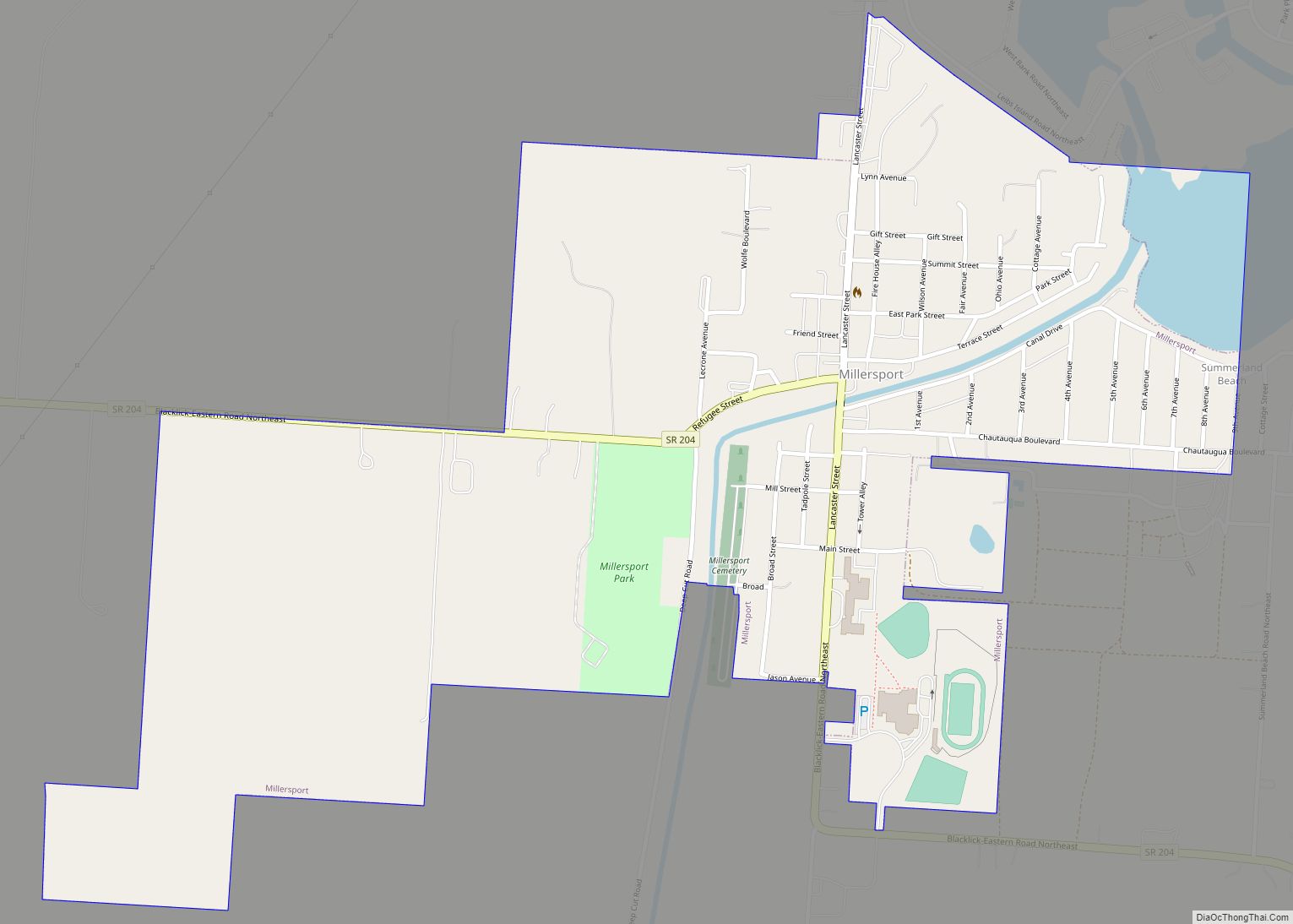
Map of Mineral City village
Mineral City is a village in Tuscarawas County, Ohio, United States. The population was 727 at the 2010 census. Mineral City village overview: Name: Mineral City village LSAD Code: 47 LSAD Description: village (suffix) State: Ohio County: Tuscarawas County Elevation: 945 ft (288 m) Total Area: 0.70 sq mi (1.82 km²) Land Area: 0.70 sq mi (1.82 km²) Water Area: 0.00 sq mi (0.00 km²) Total ... Read more
Map of Mineral City village
Map of Miltonsburg village
Miltonsburg is a village in Monroe County, Ohio, United States. The population was 42 at the 2020 census. Miltonsburg was named after Milton Pierson, son of Ohio pioneer David Pierson. David Pierson named Clarington, Ohio after his daughter Clarinda. Miltonsburg village overview: Name: Miltonsburg village LSAD Code: 47 LSAD Description: village (suffix) State: Ohio County: ... Read more
Map of Miltonsburg village
Map of Milton Center village
Milton Center is a village in Wood County, Ohio, United States. The population was 144 at the 2010 census. Milton Center village overview: Name: Milton Center village LSAD Code: 47 LSAD Description: village (suffix) State: Ohio County: Wood County Elevation: 689 ft (210 m) Total Area: 0.40 sq mi (1.03 km²) Land Area: 0.40 sq mi (1.03 km²) Water Area: 0.00 sq mi (0.00 km²) Total ... Read more
Map of Milton Center village
Map of Millville village, Ohio
Millville is a village in Butler County, Ohio, United States. The population was 634 at the 2020 census. Millville sits between Oxford, Ohio and Cincinnati, Ohio along U.S. Route 27. Millville is part of Greater Cincinnati, just west of Hamilton, Ohio. Millville village overview: Name: Millville village LSAD Code: 47 LSAD Description: village (suffix) State: ... Read more
Map of Millville village, Ohio
Map of Monroeville village, Ohio
Monroeville is a village in Huron County, Ohio, United States. The population was 1,400 at the 2010 census. Monroeville village overview: Name: Monroeville village LSAD Code: 47 LSAD Description: village (suffix) State: Ohio County: Huron County Elevation: 709 ft (216 m) Total Area: 1.43 sq mi (3.70 km²) Land Area: 1.40 sq mi (3.63 km²) Water Area: 0.03 sq mi (0.08 km²) Total Population: 1,300 Population ... Read more
Map of Monroeville village, Ohio
Map of Monroe city, Ohio
Monroe is a city in east central Butler and west central Warren counties in the southwestern part of the U.S. state of Ohio. The population was 15,412 at the 2020 census. Monroe is a part of the Cincinnati metropolitan area. Monroe city overview: Name: Monroe city LSAD Code: 25 LSAD Description: city (suffix) State: Ohio ... Read more
Map of Monroe city, Ohio
Map of Monfort Heights CDP
Monfort Heights is a census-designated place (CDP) in Green Township, Hamilton County, Ohio, United States, part of the Cincinnati–Northern Kentucky metropolitan area. The population of Monfort Heights was 12,070 at the 2020 census. In previous censuses, the area was listed as two separate CDPs, Monfort Heights East and Monfort Heights South. Monfort Heights CDP overview: ... Read more
Map of Monfort Heights CDP
Map of Mogadore village
Mogadore (/ˈmɒɡədɔːr/ MOG-ə-dor) is a village in Portage and Summit counties in the U.S. state of Ohio. The population was 3,811 at the 2020 census. A suburb of Akron, it is part of the Akron metropolitan area. Mogadore village overview: Name: Mogadore village LSAD Code: 47 LSAD Description: village (suffix) State: Ohio County: Portage County, ... Read more
Map of Mogadore village
Map of Mitiwanga CDP
Mitiwanga is an unincorporated community and census-designated place in Erie County, Ohio, United States. It is located within Berlin and Vermilion townships, on the south shore of Lake Erie. U.S. Route 6 passes through the community, leading northeast 6 miles (10 km) to Vermilion and west 5 miles (8 km) to Huron. Mitiwanga CDP overview: Name: Mitiwanga ... Read more
Map of Mitiwanga CDP
Map of Minster village
Minster is a village in Auglaize and Shelby counties, in the U.S. state of Ohio. The population was 2,805 at the 2010 census. It is included in the Wapakoneta, Ohio Micropolitan Statistical Area. It is adjacent to the village of New Bremen to the north. Minster is the home of the world’s largest yogurt plant, ... Read more
Map of Minster village
Map of Mingo Junction village
Mingo Junction is a village in eastern Jefferson County, Ohio, United States, along the Ohio River. The population was 3,347 at the 2020 census. It is part of the Weirton–Steubenville metropolitan area. Mingo Junction village overview: Name: Mingo Junction village LSAD Code: 47 LSAD Description: village (suffix) State: Ohio County: Jefferson County Elevation: 797 ft (243 m) ... Read more
Map of Mingo Junction village
Map of Minford CDP
Minford is a census-designated place located on the border of Harrison and Madison townships in northeastern Scioto County, Ohio, United States, about 14 miles (23 km) northeast of the county seat of Portsmouth. As of the 2010 census, it had a population of 693. Minford CDP overview: Name: Minford CDP LSAD Code: 57 LSAD Description: CDP ... Read more
Map of Minford CDP