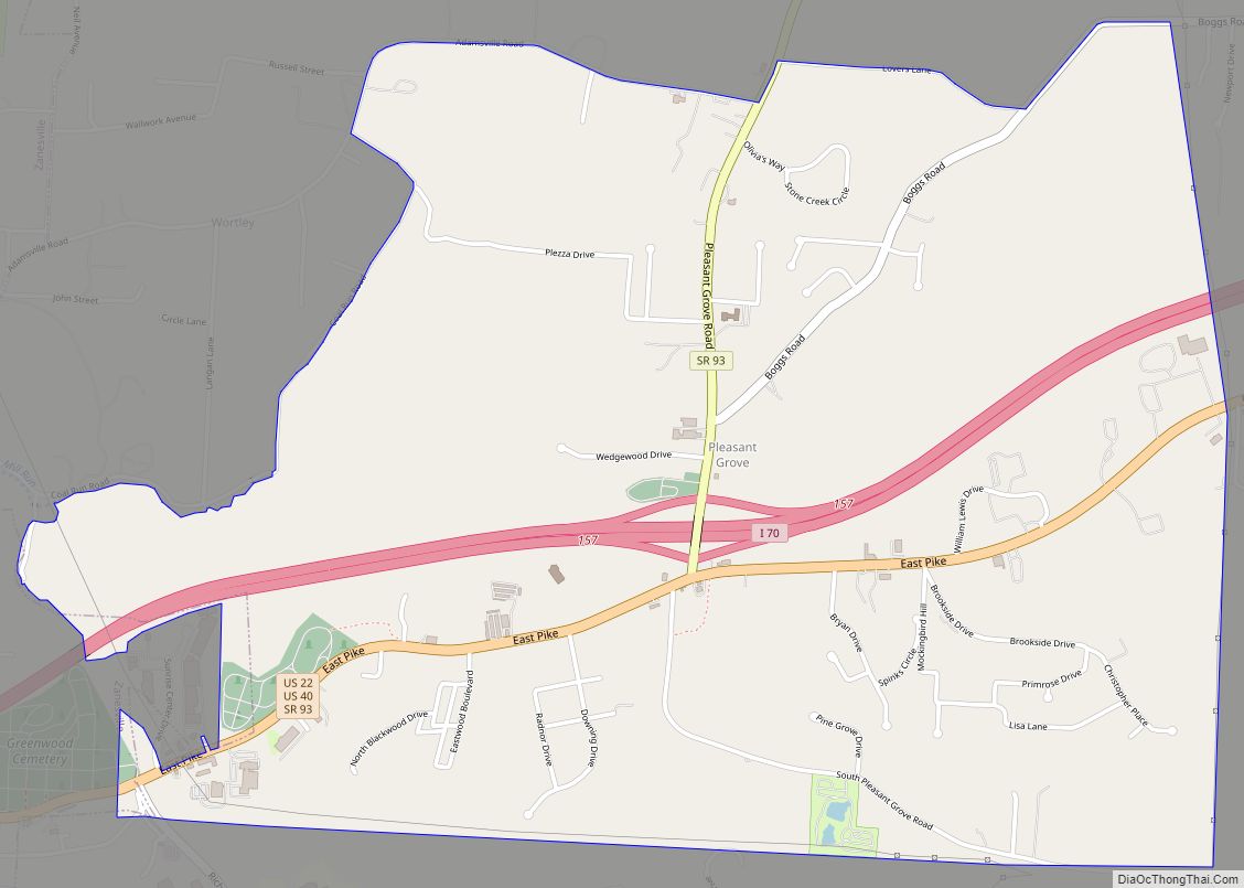
Map of Pleasant Run Farm CDP
Pleasant Run Farms is a census-designated place (CDP) in Hamilton County, Ohio, United States. The population was 4,779 at the 2020 census. Pleasant Run Farm CDP overview: Name: Pleasant Run Farm CDP LSAD Code: 57 LSAD Description: CDP (suffix) State: Ohio County: Hamilton County Elevation: 764 ft (233 m) Total Area: 1.06 sq mi (2.75 km²) Land Area: 1.06 sq mi (2.75 km²) ... Read more
Map of Pleasant Run Farm CDP
Map of Pleasant Plain village, Ohio
Pleasant Plain is a village in Harlan Township, Warren County, Ohio, United States. The population was 129 at the 2020 census. Pleasant Plain village overview: Name: Pleasant Plain village LSAD Code: 47 LSAD Description: village (suffix) State: Ohio County: Warren County Elevation: 886 ft (270 m) Total Area: 0.16 sq mi (0.42 km²) Land Area: 0.16 sq mi (0.42 km²) Water Area: 0.00 sq mi ... Read more
Map of Pleasant Plain village, Ohio
Map of Portage village, Ohio
Portage is a village in Wood County, Ohio, United States. The population was 438 at the 2010 census. Portage village overview: Name: Portage village LSAD Code: 47 LSAD Description: village (suffix) State: Ohio County: Wood County Elevation: 686 ft (209 m) Total Area: 1.49 sq mi (3.85 km²) Land Area: 1.49 sq mi (3.85 km²) Water Area: 0.00 sq mi (0.00 km²) Total Population: 398 Population ... Read more
Map of Portage village, Ohio
Map of Portage Lakes CDP
Portage Lakes is a census-designated place (CDP) in Summit County, Ohio, United States. The population was 9,870 at the 2000 census. The city of Green is adjacent to the southeast and Akron on the north. The nearby Portage Lakes of the area include but are not limited to Turkeyfoot Lake, Nimisila Reservoir, Mud Lake, and ... Read more
Map of Portage Lakes CDP
Map of Port William village
Port William is a village in Clinton County, Ohio, United States. The population was 254 at the 2010 census. Port William village overview: Name: Port William village LSAD Code: 47 LSAD Description: village (suffix) State: Ohio County: Clinton County Elevation: 1,020 ft (310 m) Total Area: 0.11 sq mi (0.29 km²) Land Area: 0.11 sq mi (0.28 km²) Water Area: 0.00 sq mi (0.01 km²) Total ... Read more
Map of Port William village
Map of Port Washington village, Ohio
Port Washington is a village in Tuscarawas County, Ohio, United States. The population was 569 at the 2010 census. Port Washington village overview: Name: Port Washington village LSAD Code: 47 LSAD Description: village (suffix) State: Ohio County: Tuscarawas County Elevation: 820 ft (250 m) Total Area: 0.56 sq mi (1.45 km²) Land Area: 0.55 sq mi (1.41 km²) Water Area: 0.01 sq mi (0.04 km²) Total ... Read more
Map of Port Washington village, Ohio
Map of Port Jefferson village, Ohio
Port Jefferson is a village in Salem Township, Shelby County, Ohio, United States. The population was 371 at the 2010 census. Port Jefferson village overview: Name: Port Jefferson village LSAD Code: 47 LSAD Description: village (suffix) State: Ohio County: Shelby County Elevation: 971 ft (296 m) Total Area: 0.15 sq mi (0.40 km²) Land Area: 0.15 sq mi (0.39 km²) Water Area: 0.00 sq mi ... Read more
Map of Port Jefferson village, Ohio
Map of Port Clinton city, Ohio
Port Clinton is a city in and the county seat of Ottawa County, located at the mouth of the Portage River on Lake Erie, about 44 miles east of Toledo. The population was 6,025 at the 2020 census. The city has been nicknamed the “Walleye Capital of the World”, due to the productive fishing waters ... Read more
Map of Port Clinton city, Ohio
Map of Pomeroy village, Ohio
Pomeroy (/ˈpʌmrɔɪ/ PUM-roy) is a village in and the county seat of Meigs County, Ohio, United States, along the Ohio River about 21 miles (34 km) south of Athens. The population was 1,573 at the 2020 census. Pomeroy village overview: Name: Pomeroy village LSAD Code: 47 LSAD Description: village (suffix) State: Ohio County: Meigs County Elevation: ... Read more
Map of Pomeroy village, Ohio
Map of Polk village, Ohio
Polk is a village in Ashland County, Ohio, United States. The population was 310 at the 2020 census. Polk village overview: Name: Polk village LSAD Code: 47 LSAD Description: village (suffix) State: Ohio County: Ashland County Elevation: 1,270 ft (387 m) Total Area: 1.04 sq mi (2.68 km²) Land Area: 1.01 sq mi (2.62 km²) Water Area: 0.02 sq mi (0.06 km²) Total Population: 310 Population ... Read more
Map of Polk village, Ohio
Map of Poland village, Ohio
Poland is a village in eastern Mahoning County, Ohio, United States. The population was 2,463 at the 2020 census. A suburb about 7 miles (11 km) south of Youngstown, it is part of the Youngstown–Warren metropolitan area. Poland village overview: Name: Poland village LSAD Code: 47 LSAD Description: village (suffix) State: Ohio County: Mahoning County Founded: ... Read more
Map of Poland village, Ohio
Map of Plymouth village, Ohio
Plymouth is a village in Huron and Richland counties in the U.S. state of Ohio. The population was 1,857 at the 2010 census. The Richland County portion of Plymouth is part of the Mansfield Metropolitan Statistical Area, while the Huron County portion is part of the Norwalk Micropolitan Statistical Area. Plymouth village overview: Name: Plymouth ... Read more
Map of Plymouth village, Ohio