Map of Williamsdale CDP
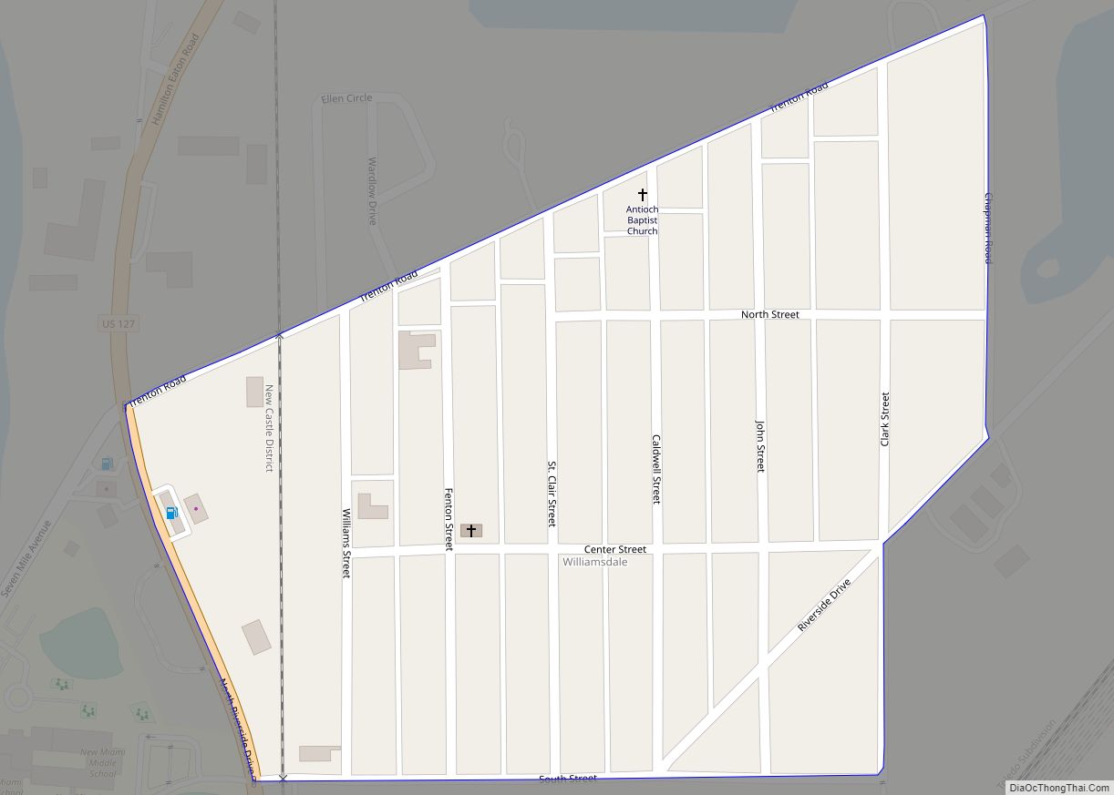
Williamsdale is a census-designated place (CDP) in St. Clair Township, Butler County, Ohio, United States. The population was 581 at the 2010 census. Williamsdale CDP overview: Name: Williamsdale CDP LSAD Code: 57 LSAD Description: CDP (suffix) State: Ohio County: Butler County Elevation: 600 ft (200 m) Total Area: 0.17 sq mi (0.45 km²) Land Area: 0.17 sq mi (0.45 km²) Water Area: 0.00 sq mi ... Read more
Map of Williamsdale CDP
Map of Williamsburg village, Ohio
Williamsburg is a village in Clermont County, Ohio, United States. The population was 2,570 at the 2020 census. Williamsburg village overview: Name: Williamsburg village LSAD Code: 47 LSAD Description: village (suffix) State: Ohio County: Clermont County Total Area: 2.59 sq mi (6.72 km²) Land Area: 2.56 sq mi (6.63 km²) Water Area: 0.04 sq mi (0.09 km²) Total Population: 2,570 Population Density: 1,004.30/sq mi (387.77/km²) ... Read more
Map of Williamsburg village, Ohio
Map of Withamsville CDP
Withamsville is a census-designated place (CDP) in Pierce and Union townships of Clermont County, Ohio, United States. The population was 7,357 at the 2020 census. Withamsville CDP overview: Name: Withamsville CDP LSAD Code: 57 LSAD Description: CDP (suffix) State: Ohio County: Clermont County Elevation: 879 ft (268 m) Total Area: 3.13 sq mi (8.10 km²) Land Area: 3.13 sq mi (8.10 km²) Water ... Read more
Map of Withamsville CDP
Map of Wintersville village
Wintersville is a village in central Jefferson County, Ohio. The population was 3,609 as of the 2020 Census. It is part of the Weirton–Steubenville metropolitan area. The village is suburban in nature and is governed by a mayor and council elected by non-partisan ballot. Wintersville village overview: Name: Wintersville village LSAD Code: 47 LSAD Description: ... Read more
Map of Wintersville village
Map of Winesburg CDP
Winesburg is an unincorporated community and census-designated place (CDP) in Paint Township, Holmes County, Ohio, in the United States. The population was 352 at the 2010 census. The community sits on the crest of a hill in the Amish country of Ohio, with a quaint downtown containing antique shops. It lies along U.S. Route 62. ... Read more
Map of Winesburg CDP
Map of Windham village, Ohio
Windham is a village in eastern Portage County, Ohio, United States. The population was 1,666 at the 2020 census. In 1942, the U.S. government chose Windham as the site of an army camp for workers at the newly built Ravenna Arsenal. As a result, Windham experienced the largest increase in population of any municipality in ... Read more
Map of Windham village, Ohio
Map of Winchester village, Ohio
Winchester is a village in Adams County, Ohio, United States. The population was 987 at the 2020 census. The name of the surrounding township is also named Winchester. State Route 136 passes through Winchester. Winchester is adjacent to Ohio State Route 32, a four lane divided highway known as the Appalachian Highway. The Appalachian Highway ... Read more
Map of Winchester village, Ohio
Map of Wilson village, Ohio
Wilson is a village in Belmont and Monroe counties in the U.S. state of Ohio. The population was 129 at the 2020 census. It is part of the Wheeling metropolitan area. Wilson village overview: Name: Wilson village LSAD Code: 47 LSAD Description: village (suffix) State: Ohio County: Belmont County, Monroe County Elevation: 1,250 ft (381 m) Total ... Read more
Map of Wilson village, Ohio
Map of Wilmot village, Ohio
Wilmot is a village in Stark County, Ohio, United States. The population was 304 at the 2010 census. It is part of the Canton–Massillon Metropolitan Statistical Area. Wilmot was originally called Milton, and under the latter name was laid out in 1836. A post office called Wilmot has been in operation since 1866. Wilmot village ... Read more
Map of Wilmot village, Ohio
Map of Wilmington city, Ohio
Wilmington is a city in and the county seat of Clinton County, Ohio, United States. The population was 12,660 at the 2020 census. At city entrances from state routes, county roads, and U.S. highways, the city slogan of “We Honor Our Champions” is seen, accompanied by signs that highlight various athletic accomplishments from Wilmington individuals ... Read more
Map of Wilmington city, Ohio
Map of Woodlawn village, Ohio
Woodlawn is a village in Hamilton County, Ohio, United States. The population was 3,916 at the 2020 census. Woodlawn village overview: Name: Woodlawn village LSAD Code: 47 LSAD Description: village (suffix) State: Ohio County: Hamilton County Total Area: 2.56 sq mi (6.62 km²) Land Area: 2.56 sq mi (6.62 km²) Water Area: 0.00 sq mi (0.00 km²) Total Population: 3,916 Population Density: 1,532.68/sq mi (591.66/km²) ... Read more
Map of Woodlawn village, Ohio
Map of Wolfhurst CDP
Wolfhurst is a census-designated place (CDP) in Belmont County, Ohio, United States. It is part of the Wheeling, West Virginia Metropolitan Statistical Area. The population was 1,239 at the 2010 census. Wolfhurst CDP overview: Name: Wolfhurst CDP LSAD Code: 57 LSAD Description: CDP (suffix) State: Ohio County: Belmont County Elevation: 690 ft (210 m) Total Area: 0.50 sq mi ... Read more
Map of Wolfhurst CDP