Map of Dewey city
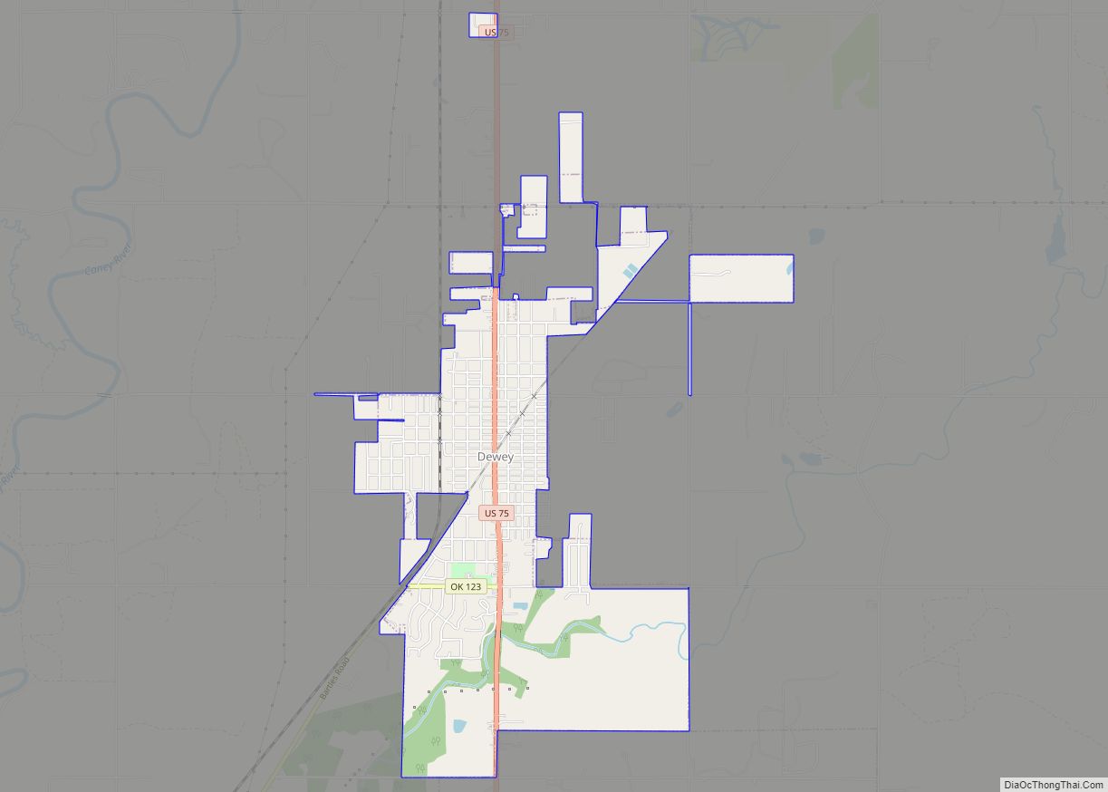
Dewey is a city in Washington County, Oklahoma, United States. Founded by Jacob A. Bartles in 1899, the town was named for Admiral George Dewey. It was incorporated December 8, 1905. The population was 3,179 at the 2000 census and 3,432 at the 2010 census, an increase of 8 percent. Dewey city overview: Name: Dewey ... Read more
Map of Dewey city
Map of Dewar town
Dewar is a town in Okmulgee County, Oklahoma, United States. The population was 818 at the 2010 census, a decline of 11.0 percent from the figure of 919 recorded in 2000. Founded in 1909 by workers for the Missouri, Oklahoma and Gulf Railway (MO&G), it was named for William Peter Dewar, a railroad official. It ... Read more
Map of Dewar town
Map of Devol town
Devol is a town in Cotton County, Oklahoma, United States. The population was 151 at the 2010 census, an increase of 0.7 percent from 150 at the 2000 census. The town is named for J. Fiske Devol, who owned the land on which it stands. Devol town overview: Name: Devol town LSAD Code: 43 LSAD ... Read more
Map of Devol town
Map of Depew town, Oklahoma
Depew is a town in Creek County, Oklahoma, United States. It is 41 miles southwest of Tulsa. The population was 476 at the 2010 census, a decline of 15.6 percent from the figure of 564 recorded in 2000. The town was named in honor of New York Senator Chauncey Depew. Depew town overview: Name: Depew ... Read more
Map of Depew town, Oklahoma
Map of Dennis CDP, Oklahoma
Dennis is an unincorporated community and census-designated place (CDP) in Delaware County, Oklahoma, near Grand Lake. The population was 195 at the 2010 census. The Dennis Post Office existed from March 25, 1914, until January 31, 1956. It is said to be named for a local resident, Peter Dennis. Dennis CDP overview: Name: Dennis CDP ... Read more
Map of Dennis CDP, Oklahoma
Map of Delaware town, Oklahoma
Delaware is a town in Nowata County, Oklahoma, United States. The population was 267 at the 2020 census, a decline of 35.9 percent from the figure of 417 recorded in 2010. The town is named for the Eastern Delaware tribe that moved into this area from Kansas after signing a treaty with the Cherokee Nation ... Read more
Map of Delaware town, Oklahoma
Map of Douglas town, Oklahoma
Douglas is a town in Garfield County, Oklahoma, United States. The population was 32 at the 2010 census. Douglas town overview: Name: Douglas town LSAD Code: 43 LSAD Description: town (suffix) State: Oklahoma County: Garfield County Elevation: 1,145 ft (349 m) Total Area: 0.25 sq mi (0.66 km²) Land Area: 0.25 sq mi (0.66 km²) Water Area: 0.00 sq mi (0.00 km²) Total Population: 51 Population ... Read more
Map of Douglas town, Oklahoma
Map of Dougherty town, Oklahoma
Dougherty is a town in Murray County, Oklahoma, United States. The population was 224 at the 2000 census. American jazz and pop singer Kay Starr was born in Dougherty. Dougherty town overview: Name: Dougherty town LSAD Code: 43 LSAD Description: town (suffix) State: Oklahoma County: Murray County Elevation: 774 ft (236 m) Total Area: 0.38 sq mi (0.98 km²) Land ... Read more
Map of Dougherty town, Oklahoma
Map of Dotyville CDP
Dotyville is a census-designated place (CDP) in Ottawa County, Oklahoma, United States. The population was 101 at the 2010 census. Dotyville is a part of the Joplin, Missouri metropolitan area. Dotyville CDP overview: Name: Dotyville CDP LSAD Code: 57 LSAD Description: CDP (suffix) State: Oklahoma County: Ottawa County Elevation: 774 ft (236 m) Total Area: 0.46 sq mi (1.19 km²) ... Read more
Map of Dotyville CDP
Map of Dodge CDP, Oklahoma
Dodge is an unincorporated community and census-designated place (CDP) in Delaware County, Oklahoma, United States. The population was 115 at the 2010 census, up from the figure of 96 recorded in 2000. The Dodge Post Office existed from November 20, 1901, until August 15, 1941. Dodge was established on Cowskin Prairie along the St. Louis-San ... Read more
Map of Dodge CDP, Oklahoma
Map of Dry Creek CDP, Oklahoma
Dry Creek is an unincorporated community and census-designated place (CDP) in Cherokee County, Oklahoma, United States. The population was 227 at the 2010 census. Dry Creek CDP overview: Name: Dry Creek CDP LSAD Code: 57 LSAD Description: CDP (suffix) State: Oklahoma County: Cherokee County Total Area: 8.70 sq mi (22.53 km²) Land Area: 8.69 sq mi (22.51 km²) Water Area: 0.01 sq mi ... Read more
Map of Dry Creek CDP, Oklahoma
Map of Drumright city
Drumright is a city in Creek and Payne counties in the U.S. state of Oklahoma. It began as an oil boom town. However, the population has declined as oil production has waned in the area. The population was 2,907 at the 2010 census, a figure almost unchanged from 2,905 in 2000. Drumright and nearby Cushing ... Read more
Map of Drumright city