Map of Eloy city
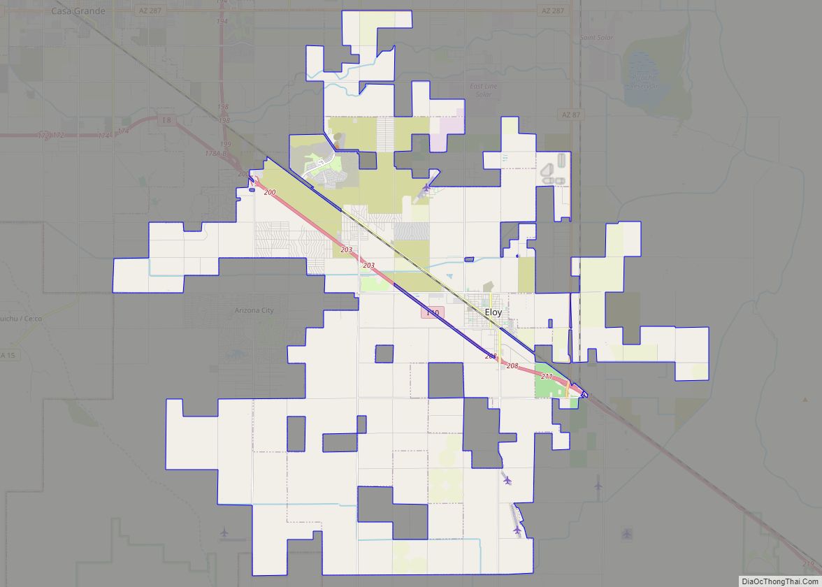
Eloy is a city in Pinal County, Arizona, United States, approximately 50 miles (80 km) northwest of Tucson and about 65 miles (105 km) southeast of Phoenix. According to the U.S. Census estimates in 2020, the population of the city is 15,635. Eloy city overview: Name: Eloy city LSAD Code: 25 LSAD Description: city (suffix) State: Arizona ... Read more
Map of Eloy city
Map of Elgin CDP, Arizona
Elgin is a census-designated place (CDP) in Santa Cruz County, Arizona, United States. The population was 161 at the 2010 census. Elgin CDP overview: Name: Elgin CDP LSAD Code: 57 LSAD Description: CDP (suffix) State: Arizona County: Santa Cruz County Elevation: 4,728 ft (1,441 m) Total Area: 5.95 sq mi (15.41 km²) Land Area: 5.95 sq mi (15.40 km²) Water Area: 0.00 sq mi (0.00 km²) ... Read more
Map of Elgin CDP, Arizona
Map of Flagstaff city
Flagstaff city overview: Name: Flagstaff city LSAD Code: 25 LSAD Description: city (suffix) State: Arizona County: Coconino County Incorporated: 1928 Elevation: 6,910 ft (2,106 m) Land Area: 66.03 sq mi (171.02 km²) Water Area: 0.05 sq mi (0.14 km²) Population Density: 1,163.59/sq mi (449.26/km²) Area code: 928 FIPS code: 0423620 Website: flagstaff.az.gov Online Interactive Map Flagstaff online map. Source: Basemap layers from Google Map, ... Read more
Map of Flagstaff city
Map of Flowing Springs CDP
Flowing Springs is a census-designated place in Gila County in the U.S. state of Arizona. Flowing Springs is located approximately eight miles north of the town of Payson. The population was 34 at the 2020 census, down from 42 at the 2010 census. Flowing Springs CDP overview: Name: Flowing Springs CDP LSAD Code: 57 LSAD ... Read more
Map of Flowing Springs CDP
Map of Florence town, Arizona
Florence (O’odham: S-auppag) is a town, 61 miles (98 km) southeast of Phoenix, in Pinal County, Arizona, United States. Florence, which is the county seat of Pinal County, is one of the oldest towns in that county and is regarded as a National Historic District with over 25 buildings listed on the National Register of Historic ... Read more
Map of Florence town, Arizona
Map of Fort Defiance CDP
Fort Defiance (Navajo: Tséhootsooí [tsʰéhòːtsʰòː.í]) is a census-designated place (CDP) in Apache County, Arizona, United States. It is also located within the Navajo Nation. The population was 3,624 at the 2010 census. Fort Defiance CDP overview: Name: Fort Defiance CDP LSAD Code: 57 LSAD Description: CDP (suffix) State: Arizona County: Apache County Elevation: 6,836 ft (2,084 m) ... Read more
Map of Fort Defiance CDP
Map of Fort Apache CDP
Fort Apache (Western Apache: Tłʼog Hagai) is an unincorporated community in Navajo County, Arizona, United States. Fort Apache is on the Fort Apache Indian Reservation, 2 miles (3.2 km) east of Canyon Day. Fort Apache has a post office with ZIP code 85926. Fort Apache CDP overview: Name: Fort Apache CDP LSAD Code: 57 LSAD Description: ... Read more
Map of Fort Apache CDP
Map of Flowing Wells CDP
Flowing Wells is a census-designated place (CDP) in Pima County, Arizona, United States. It is a suburb of Tucson. The population was 16,419 at the 2010 census. The Flowing Wells community was given an All-American City Award by the National Civic League in 2007. Flowing Wells CDP overview: Name: Flowing Wells CDP LSAD Code: 57 ... Read more
Map of Flowing Wells CDP
Map of Fort Valley CDP, Arizona
Fort Valley is a census-designated place in the southern portion of Coconino County in the state of Arizona, United States. Fort Valley is located very close to the city of Flagstaff. The population as of 2010, was 779. Fort Valley CDP overview: Name: Fort Valley CDP LSAD Code: 57 LSAD Description: CDP (suffix) State: Arizona ... Read more
Map of Fort Valley CDP, Arizona
Map of Fort Thomas CDP, Arizona
Fort Thomas (Western Apache: Gowąh Golgai Gohoshé) is a census-designated place in Graham County, Arizona, United States. Its population was 319 as of the 2020 census. The community has an elementary school and a high school. It is part of the Safford Micropolitan Statistical Area. Fort Thomas has a ZIP code of 85536. Fort Thomas ... Read more
Map of Fort Thomas CDP, Arizona
Map of Fort Mohave CDP
Fort Mohave is an unincorporated community and CDP in Mohave County, Arizona, United States. It is named for a nearby fort that was used during the Mohave War. As of the 2020 census, the population of Fort Mohave was 16,190, up from 14,364 in 2010 and 8,919 in 2000. It is a suburb of Bullhead ... Read more
Map of Fort Mohave CDP
Map of Franklin CDP, Arizona
Franklin is an unincorporated community and census-designated place in Greenlee County, Arizona, United States. As of the 2010 census it had a population of 92. It is located in southern Greenlee County along U.S. Route 70, 3 miles (4.8 km) west of the border with New Mexico, 3 miles (4.8 km) south of Duncan, and 32 miles ... Read more
Map of Franklin CDP, Arizona