Map of Frederick city, Oklahoma
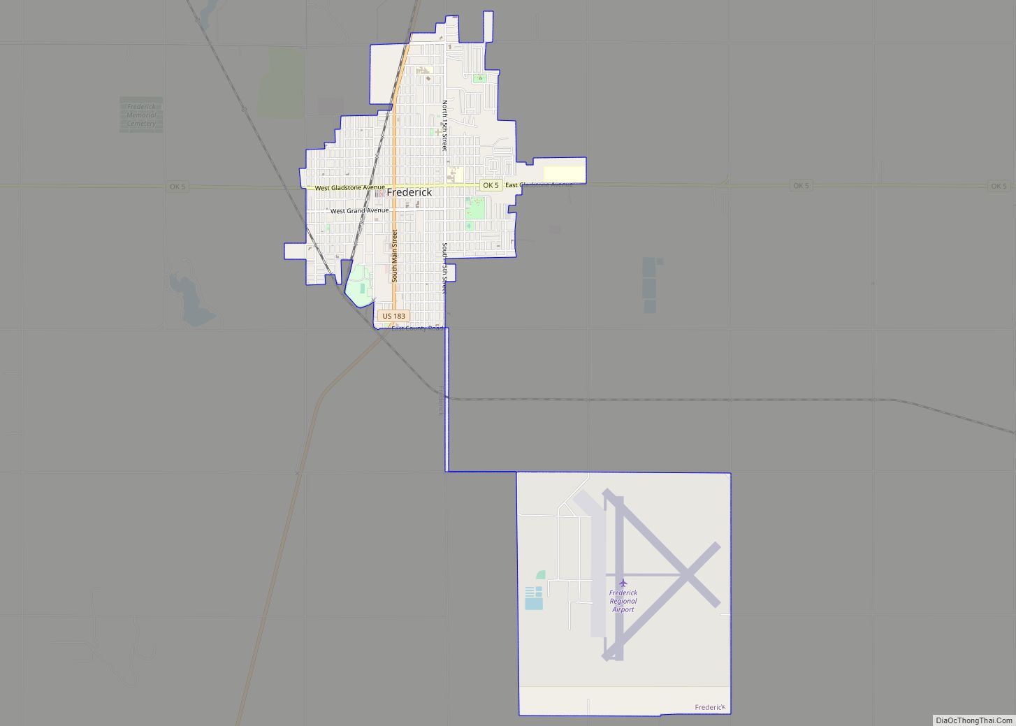
Frederick is a city and county seat of Tillman County, Oklahoma, United States. The population was 3,940 at the 2010 census. It is an agriculture-based community that primarily produces wheat, cotton, and cattle. Frederick is home to three dairies, a 1400-acre industrial park, and Frederick Regional Airport, which includes restored World War II hangars which ... Read more
Map of Frederick city, Oklahoma
Map of Francis town, Oklahoma
Francis is a town in Pontotoc County, Oklahoma, United States. The population was 332 at the 2000 census. Francis town overview: Name: Francis town LSAD Code: 43 LSAD Description: town (suffix) State: Oklahoma County: Pontotoc County Elevation: 945 ft (288 m) Total Area: 0.56 sq mi (1.45 km²) Land Area: 0.56 sq mi (1.45 km²) Water Area: 0.00 sq mi (0.00 km²) Total Population: 244 Population ... Read more
Map of Francis town, Oklahoma
Map of Geary city
Geary is a city in Blaine and Canadian counties in the U.S. state of Oklahoma. The population was 994 at the 2020 census. The town was named for Edmund Guerrier, a scout and an interpreter for the U.S. Army. Geary city overview: Name: Geary city LSAD Code: 25 LSAD Description: city (suffix) State: Oklahoma County: ... Read more
Map of Geary city
Map of Gate town
Gate is a town in Beaver County, Oklahoma, United States. The population was 93 at the 2010 census. The community was named for the fact it was the “gateway” to a ranching area. Gate town overview: Name: Gate town LSAD Code: 43 LSAD Description: town (suffix) State: Oklahoma County: Beaver County Elevation: 2,267 ft (691 m) Total ... Read more
Map of Gate town
Map of Gore town
Gore is a town in western Sequoyah County, Oklahoma, United States. It is part of the Fort Smith, Arkansas-Oklahoma Metropolitan Statistical Area. The population was 977 at the 2010 census, an increase of 15 percent over the figure of 850 recorded in 2000. Gore claims to be the “trout capital of Oklahoma“, with great fishing ... Read more
Map of Gore town
Map of Goodwell town
Goodwell is a town in Texas County, Oklahoma, United States. The population was 1,293 at the 2010 census. Goodwell is home to Oklahoma Panhandle State University. Goodwell town overview: Name: Goodwell town LSAD Code: 43 LSAD Description: town (suffix) State: Oklahoma County: Texas County Elevation: 3,304 ft (1,007 m) Total Area: 2.22 sq mi (5.75 km²) Land Area: 2.20 sq mi (5.69 km²) ... Read more
Map of Goodwell town
Map of Goltry town
Goltry is a town in Alfalfa County, Oklahoma, United States. The population was 249 at the 2010 census. Goltry shares the Timberlake school district with the nearby towns of Helena, Jet, and Nash. Goltry town overview: Name: Goltry town LSAD Code: 43 LSAD Description: town (suffix) State: Oklahoma County: Alfalfa County Elevation: 1,380 ft (420 m) Total ... Read more
Map of Goltry town
Map of Goldsby town
Goldsby is a town in McClain County, Oklahoma, United States. It lies within the Washington public school district and is home to the second largest casino in Oklahoma. As of the 2020 Census, the estimated population was 2,694, a 66 percent increase since 2010. Goldsby town overview: Name: Goldsby town LSAD Code: 43 LSAD Description: ... Read more
Map of Goldsby town
Map of Glenpool city
Glenpool is a city in Tulsa County, Oklahoma, United States. It is part of the Tulsa Metropolitan Statistical Area (TMSA). As of 2020, the population was 14,040, which represented an increase of 29.9% since the 2010 census, which reported the total population as 10,808. Glenpool is notable because the discovery of oil in 1905, which ... Read more
Map of Glenpool city
Map of Glencoe town, Oklahoma
Glencoe is a town in northern Payne County, Oklahoma, United States. The population was 601 at the 2010 census, an increase of 3.1 percent from the figure of 583 in 2000. Glencoe is a midway point between Pawnee County and Stillwater, which is the county seat. The city has recently been the site of economic ... Read more
Map of Glencoe town, Oklahoma
Map of Gideon CDP, Oklahoma
Gideon is an unincorporated community and census-designated place (CDP) in Cherokee County, Oklahoma, United States. The population was 49 at the 2010 census. Gideon CDP overview: Name: Gideon CDP LSAD Code: 57 LSAD Description: CDP (suffix) State: Oklahoma County: Cherokee County Total Area: 6.31 sq mi (16.34 km²) Land Area: 6.31 sq mi (16.34 km²) Water Area: 0.00 sq mi (0.00 km²) Total Population: ... Read more
Map of Gideon CDP, Oklahoma
Map of Gerty town
Gerty is a town in southern Hughes County, Oklahoma, United States. The population was 118 at the 2010 census. Gerty town overview: Name: Gerty town LSAD Code: 43 LSAD Description: town (suffix) State: Oklahoma County: Hughes County Elevation: 843 ft (257 m) Total Area: 0.25 sq mi (0.65 km²) Land Area: 0.25 sq mi (0.65 km²) Water Area: 0.00 sq mi (0.00 km²) Total Population: 92 ... Read more
Map of Gerty town