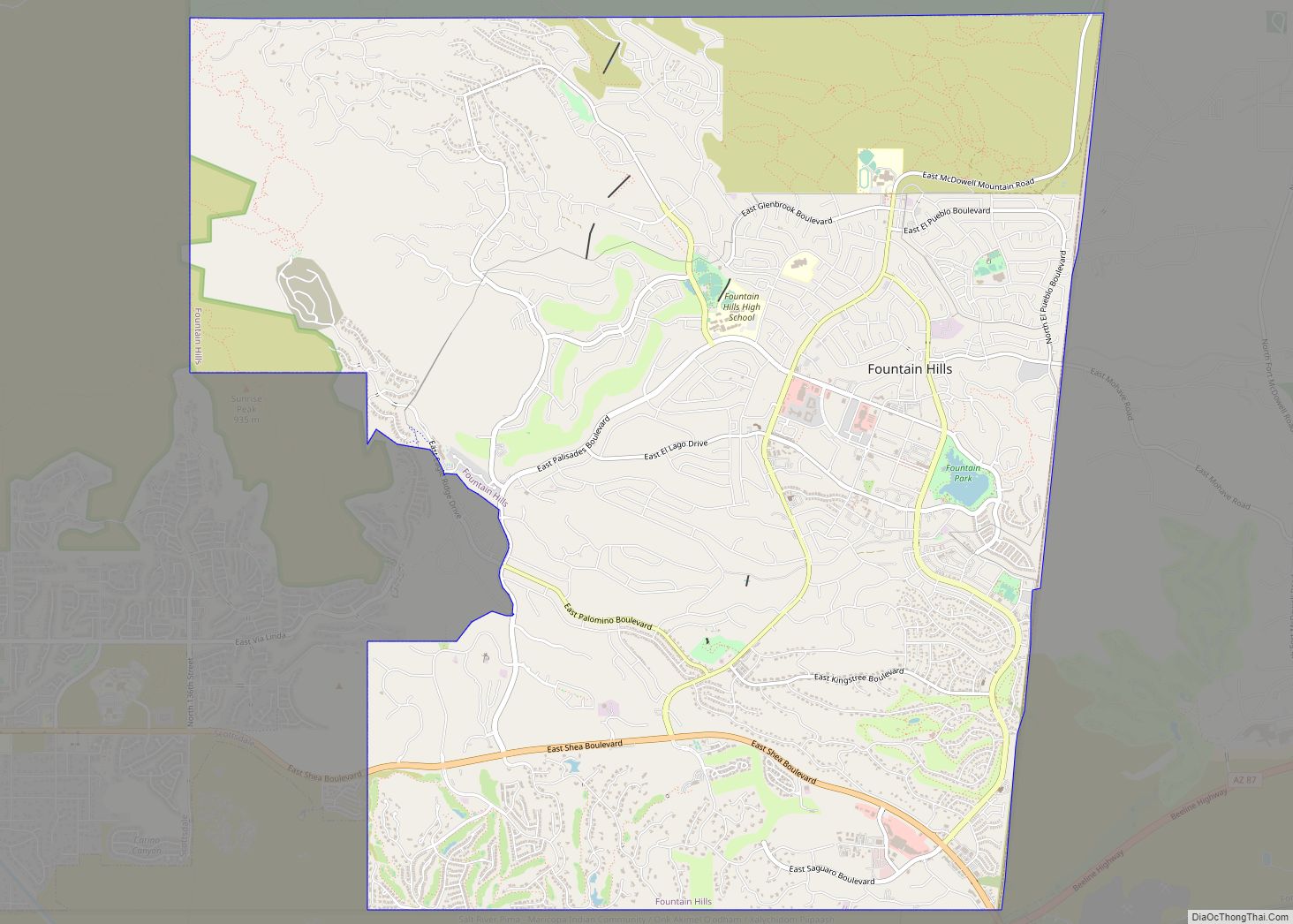
Fountain Hills is a town in Maricopa County, Arizona, United States. Known for its impressive fountain, once the tallest in the world, it borders the Fort McDowell Yavapai Nation, Salt River Pima-Maricopa Indian Community, and Scottsdale. The population was 23,820 as of the 2020 census. Between the 1990 and 2000 censuses it was the eighth-fastest-growing ... Read more
Map of US Cities and Places
Fortuna Foothills is a census-designated place (CDP) in Yuma County, Arizona, United States. The population was 26,265 at the 2010 census. It is part of the Yuma Metropolitan Statistical Area. Development of the area began in the 1960s, when local developer Hank Schechert purchased 3,000 acres east of Yuma. Fortuna Foothills serves as a bedroom ... Read more
Gadsden is a census-designated place (CDP) in Yuma County, Arizona, United States. The population was 953 at the 2000 census. It is part of the Yuma Metropolitan Statistical Area. Gadsden CDP overview: Name: Gadsden CDP LSAD Code: 57 LSAD Description: CDP (suffix) State: Arizona County: Yuma County Elevation: 98 ft (30 m) Total Area: 1.95 sq mi (5.06 km²) Land ... Read more
Freedom Acres is a census-designated place (CDP) in Gila County, Arizona, United States. The population was 90 at the 2020 census, up from 84 at the 2010 census. Freedom Acres CDP overview: Name: Freedom Acres CDP LSAD Code: 57 LSAD Description: CDP (suffix) State: Arizona County: Gila County Elevation: 4,880 ft (1,490 m) Total Area: 1.75 sq mi (4.54 km²) ... Read more
Fredonia is a town in Coconino County, Arizona, United States. As of the 2010 census it had a population of 1,314. Fredonia is the gateway to the North Rim of the Grand Canyon. Fredonia town overview: Name: Fredonia town LSAD Code: 43 LSAD Description: town (suffix) State: Arizona County: Coconino County Elevation: 4,671 ft (1,424 m) Total ... Read more
Gila Bend (/ˌhiːlə ˈbɛnd/; O’odham: Hila Wi:n), founded in 1872, is a town in Maricopa County, Arizona, United States. The town is named for an approximately 90-degree bend in the Gila River, which is near the community’s current location. As of the 2020 census, the population of the town was 1,892. Just outside the town ... Read more
Geronimo Estates is both a census-designated place (CDP) and a populated place in Gila County, Arizona, United States. The population of the CDP was 60 at the 2010 census. Geronimo Estates CDP overview: Name: Geronimo Estates CDP LSAD Code: 57 LSAD Description: CDP (suffix) State: Arizona County: Gila County Elevation: 5,334 ft (1,626 m) Total Area: 1.38 sq mi ... Read more
Ganado (Navajo: Lókʼaahnteel) is a chapter of the Navajo Nation and census-designated place (CDP) in Apache County, Arizona, United States. The population was 1,210 at the 2010 census. Ganado is part of the Fort Defiance Agency, of the Bureau of Indian Affairs; and is the delegate seat for the district that encompasses the Jeddito, Cornfields, ... Read more
Gila Crossing (O’odham: Kuiwa) is a census-designated place (CDP) in Maricopa County, Arizona, United States, within the Gila River Indian Community south of Komatke. The population was 636 at the 2020 census. Gila Crossing CDP overview: Name: Gila Crossing CDP LSAD Code: 57 LSAD Description: CDP (suffix) State: Arizona County: Maricopa County Total Area: 0.87 sq mi ... Read more
Globe (Western Apache: Bésh Baa Gowąh “Place of Metal”) is a city in Gila County, Arizona, United States. As of the 2020 census, the population of the city was 7,249. The city is the county seat of Gila County. Globe was founded c. 1875 as a mining camp. Mining, tourism, government and retirees are most ... Read more
Gisela (/ɡaɪˈsiːlə/ ghy-SEE-lə) is an unincorporated community and census-designated place (CDP) in Gila County, Arizona, United States. The population was 570 at the 2010 census. Gisela was named after the heroine in the book Countess Gisela by E. Marlitt. The town schoolteacher was reading the book to her students when she was asked by her ... Read more
Golden Valley is an unincorporated area and census-designated place (CDP) in Mohave County, Arizona, United States. The population was 8,801 at the 2020 census. Golden Valley CDP overview: Name: Golden Valley CDP LSAD Code: 57 LSAD Description: CDP (suffix) State: Arizona County: Mohave County Elevation: 2,805 ft (855 m) Total Area: 78.75 sq mi (203.95 km²) Land Area: 78.75 sq mi (203.95 km²) ... Read more