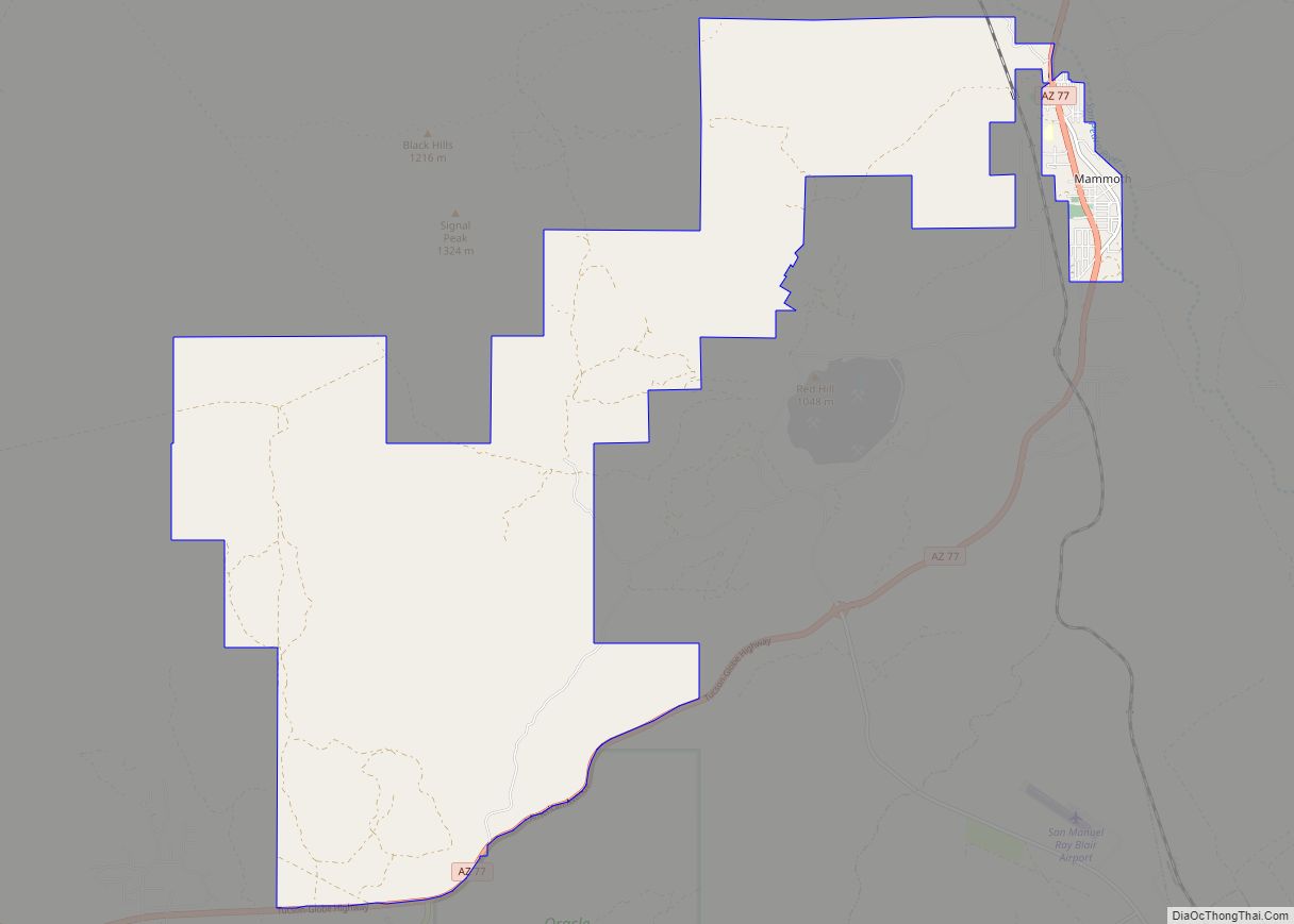
Mammoth is a town in Pinal County, Arizona, United States. The population was 1,426 at the 2010 census; according to 2018 Census Bureau estimates, the population of the town is 1,650. Mammoth town overview: Name: Mammoth town LSAD Code: 43 LSAD Description: town (suffix) State: Arizona County: Pinal County Founded: c. 1872 Incorporated: 1958 Elevation: ... Read more
Map of US Cities and Places
Maish Vaya is a census-designated place (CDP) in Pima County, Arizona, United States. The population was 158 at the 2010 census. Maish Vaya CDP overview: Name: Maish Vaya CDP LSAD Code: 57 LSAD Description: CDP (suffix) State: Arizona County: Pima County Elevation: 2,556 ft (779 m) Total Area: 4.24 sq mi (10.97 km²) Land Area: 4.24 sq mi (10.97 km²) Water Area: 0.00 sq mi ... Read more
Maricopa is a city in the Gila River Valley in Pinal County, Arizona, United States. With 66,290 residents as of 2022, Maricopa is the largest incorporated municipality in Pinal County. Maricopa city overview: Name: Maricopa city LSAD Code: 25 LSAD Description: city (suffix) State: Arizona County: Pinal County Incorporated: 2003 Elevation: 1,201 ft (366 m) Total Area: ... Read more
Maricopa Colony is a census-designated place (CDP) in Maricopa County, Arizona, United States, located in the federally recognized Gila River Indian Community. The population was 854 at the 2020 census, up from 709 at the 2010 census. It is located on the southern side of the Phoenix metropolitan area, around Baseline Road and 83rd Avenue. ... Read more
Marana is a town in Pima County, Arizona, United States, located northwest of Tucson, with a small portion in Pinal County. According to the 2021 Census, the population of the town was 54,895. From 1990 to 2000, Marana was the fourth fastest-growing place among all cities and towns of any size in Arizona. Marana town ... Read more
McConnico is an unincorporated community and census-designated place (CDP) in Mohave County, Arizona, United States. The population was 63 at the 2020 census. McConnico CDP overview: Name: McConnico CDP LSAD Code: 57 LSAD Description: CDP (suffix) State: Arizona County: Mohave County Elevation: 3,068 ft (935 m) Total Area: 6.58 sq mi (17.05 km²) Land Area: 6.58 sq mi (17.05 km²) Water Area: 0.00 sq mi ... Read more
Mayer is a census-designated place (CDP) in Yavapai County, Arizona, United States. The population was 1,408 at the 2000 census. Mayer includes three sites listed on the National Register of Historic Places: Mayer Apartments, Mayer Business Block, and Mayer Red Brick Schoolhouse. Mayer CDP overview: Name: Mayer CDP LSAD Code: 57 LSAD Description: CDP (suffix) ... Read more
Martinez Lake is a census-designated place (CDP) in Yuma County, Arizona, United States. The population was 798 at the 2010 census. It was founded in 1958 as a fishing community. It remains primarily a vacation community. Martinez Lake CDP overview: Name: Martinez Lake CDP LSAD Code: 57 LSAD Description: CDP (suffix) State: Arizona County: Yuma ... Read more
Mead Ranch is a census-designated place (CDP) in Gila County, Arizona, United States. The population was 38 at the 2010 census. Mead Ranch CDP overview: Name: Mead Ranch CDP LSAD Code: 57 LSAD Description: CDP (suffix) State: Arizona County: Gila County Elevation: 6,000 ft (2,000 m) Total Area: 0.60 sq mi (1.55 km²) Land Area: 0.60 sq mi (1.55 km²) Water Area: 0.00 sq mi ... Read more
McNeal is an unincorporated community and census-designated place in Cochise County, Arizona, United States. As of the 2010 United States Census it had a population of 238. McNeal is located on U.S. Route 191, 21 miles (34 km) northwest of Douglas. McNeal has the United States Postal Service zip code of 85617. McNeal CDP overview: Name: ... Read more
McNary (Western Apache: Chaabiitú) is a census-designated place (CDP) in Apache and Navajo counties in the U.S. state of Arizona, on the Fort Apache Indian Reservation. The population was 528 at the 2010 census. It is a 30-minute drive from Show Low and a 10-minute drive from Pinetop-Lakeside. McNary CDP overview: Name: McNary CDP LSAD ... Read more
Mescal is a Census-designated place located in Cochise County, Arizona, United States. Mescal was originally a populated place, at a rail station on the Southern Pacific Railroad at an elevation of 4,085 feet. The modern community lies to the south of the railroad near Interstate 10, at 4,170 feet. Mescal had a population of 1,812 ... Read more