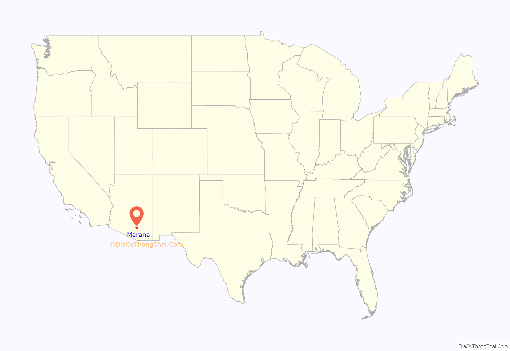
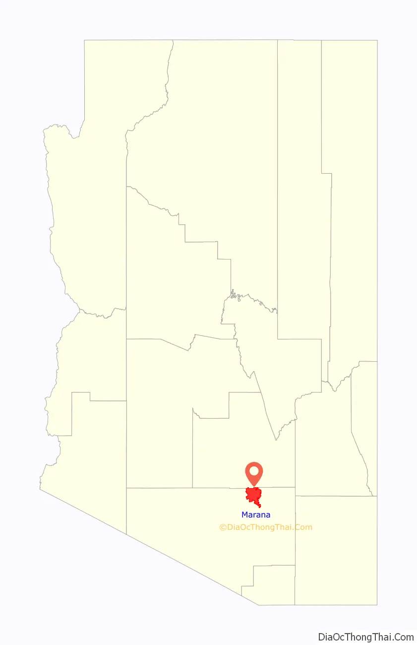
Marana is a town in Pima County, Arizona, United States, located northwest of Tucson, with a small portion in Pinal County. According to the 2021 Census, the population of the town was 54,895. From 1990 to 2000, Marana was the fourth fastest-growing place among all cities and towns of any size in Arizona.
| Name: | Marana town |
|---|---|
| LSAD Code: | 43 |
| LSAD Description: | town (suffix) |
| State: | Arizona |
| County: | Pima County, Pinal County |
| Incorporated: | 1977 |
| Elevation: | 1,991 ft (607 m) |
| Total Area: | 121.78 sq mi (315.41 km²) |
| Land Area: | 121.10 sq mi (313.65 km²) |
| Water Area: | 0.68 sq mi (1.77 km²) |
| Total Population: | 51,908 |
| Population Density: | 428.64/sq mi (165.50/km²) |
| ZIP code: | 85653, 85658, 85743 |
| Area code: | 520 |
| FIPS code: | 0444270 |
| GNISfeature ID: | 7681 |
| Website: | http://www.marana.com/ |
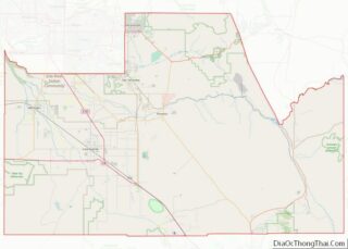
Online Interactive Map
Click on ![]() to view map in "full screen" mode.
to view map in "full screen" mode.
Marana location map. Where is Marana town?
History
Archaeologists found evidence of about 4,200 years of continuous human settlement in the vicinity of Marana and in the middle of Santa Cruz Valley. Many significant archaeological sites have been found near Marana.
- Las Capas, a large, early agricultural site, is related to the nearby Costello-King site near present-day Ina Road and the Interstate 10 interchange. It was occupied from 4,200 to 2,500 years ago. It is the site of the oldest-known cemetery in the American Southwest and the oldest-known canals in North America. The oldest tobacco pipes in the world were found here.
- Los Morteros, a Hohokam ballcourt village ruin, is located on the Santa Cruz floodplain near the Point of the Mountain at the northern end of the Tucson Mountains. Los Morteros has also been identified as the probable location of the Llano del Azotado campsite used by the Juan Bautista de Anza expedition in 1775, which was chronicled. The location is near the present-day Arizona Portland Cement Plant in the Town of Marana.
- Linda Vista Hill, dating between 1200 and 1350 A.D., is a Trincheras culture site in the Tucson Mountains. The people inhabited mountain slopes overlooking arable land along streams. The hillside site has more than 150 terraces and 75 pit houses excavated into the terraces. A massive, adobe-walled compound is located on the hill summit.
- Marana Mound, dating between 1150 and 1300 A.D., is the remnant of a large platform mound that was the center of the Hohokam community. The people lived between the Santa Cruz River and the Tortolita Mountains. The mound is surrounded by an adobe compound wall. Multiple rooms were constructed against the wall and were associated with 30–35 nearby residential compounds. Multiple house features have been found both inside and outside the compounds, as well as wall segments and trash mounds. The whole complex covers an area of approximately one square mile.
- In 1775, Juan Bautista de Anza, Captain of the Presidio of Tubac, led an expedition north along the Santa Cruz River to find the city of San Francisco. His group of about 200 included 30 soldiers and their families and a number of escorts. They brought more than 1,000 heads of livestock. Their campsite was developed in the 20th century as the CalPortland Cement Plant near Marana. A 15-mile (24 km) segment of the route that the expedition took through Marana is designated as part of the Juan Bautista de Anza National Historic Trail.
- Pointer Mountain Station, of the Butterfield Overland Mail stagecoach line used from 1858, was found during the study of Los Morteros, within the limits of the nearby Puerta del Norte trailer court.
Spanish colonists began to inhabit this area in the 17th and 18th centuries. Over time they intermarried with Native Americans, and a class of mestizo settlers also developed. From the early years, mining and ranching were the chief economic activities. The area became part of the independent Mexican Empire established in 1821 (soon replaced by the Republic of Mexico).
US territory
More than two decades later, the United States acquired this territory as part of the Gadsden Purchase; it was not part of the Mexican Cession following the defeat in the Mexican-American War, ending in 1848.
20th-century pioneers
According to historian David Leighton, Charles B. Anway was the first member of the Anway family in the Tucson area; from the eastern United States, he came because the dry mountain air was thought to be beneficial for people suffering from tuberculosis, as he was. Antibiotics were not yet in general use to treat this disease, which had a high mortality rate and no known cure. In 1919, his brother William and his two children, Louis and Ila, arrived in town, but they decided to settle in an area northwest of Tucson called Postvale, Arizona.
In 1920, the longtime widower William Anway married Orpha Ralston. She had been a member for many years of the Postvale Co-operative Women’s Club. This group lobbied to have the local post office renamed from Postvale to Marana; in time, the town was also named Marana.
Marana did not become developed primarily as an agricultural center, until after World War I. It has produced commodity crops of cotton, wheat, barley, alfalfa, and pecans.
During World War II, the Army built facilities here to support the military effort. Before the Air Force was established, the Army built and operated the Marana Airfield (1942–45). It became the largest pilot-training center in the world, training some 10,000 flyers.
In the postwar years, five Titan missile sites were constructed in the area as part of a complex of ballistic missile installations built around Tucson. This was during the Cold War when tensions were high with the Soviet Union.
In March 1977, the Town incorporated about 10 square miles (26 km) and in August of that year, the 1,500 residents elected their first town council. In early 1979, the town began to grow through a targeted annexation policy. It now measures a little more than 120 square miles (310 km) with a population of over 43,000.
Annexation
The southern portion of Marana has grown considerably since the early 1990s, with the addition of businesses and some housing. This is largely due to the annexation of existing unincorporated areas. In 1992, the Marana Town Council voted to annex an area of unincorporated Pima County that was located southeast of the town limits. The area selected was a narrow corridor of land along Interstate 10, to the east along Ina Road, and south along Thornydale Road. These areas were mainly developed as high-density commercial businesses and shopping centers, including large retailers or “big box” stores such as Super KMart (now closed), Costco Wholesale, Target, and Home Depot. Marana chose these areas to annex to increase its revenue from sales taxes. The large residential areas behind these commercial areas, which required support for residents, such as schools and roads, were not annexed.
As a result, the city of Tucson filed a lawsuit in the Superior Court of the State of Arizona in and for the County of Pima (City of Tucson v Town of Marana), claiming that Marana illegally annexed the unincorporated areas in violation of existing state laws. However, on April 4, 1994, Judge Lina Rodriguez ruled in favor of Marana, allowing the annexation to stand. Following this suit, the Arizona State annexation laws were changed, forbidding municipalities from annexing small strips of land without taking large surrounding parcels as well. Such “strip annexation” is no longer allowed under Arizona law.
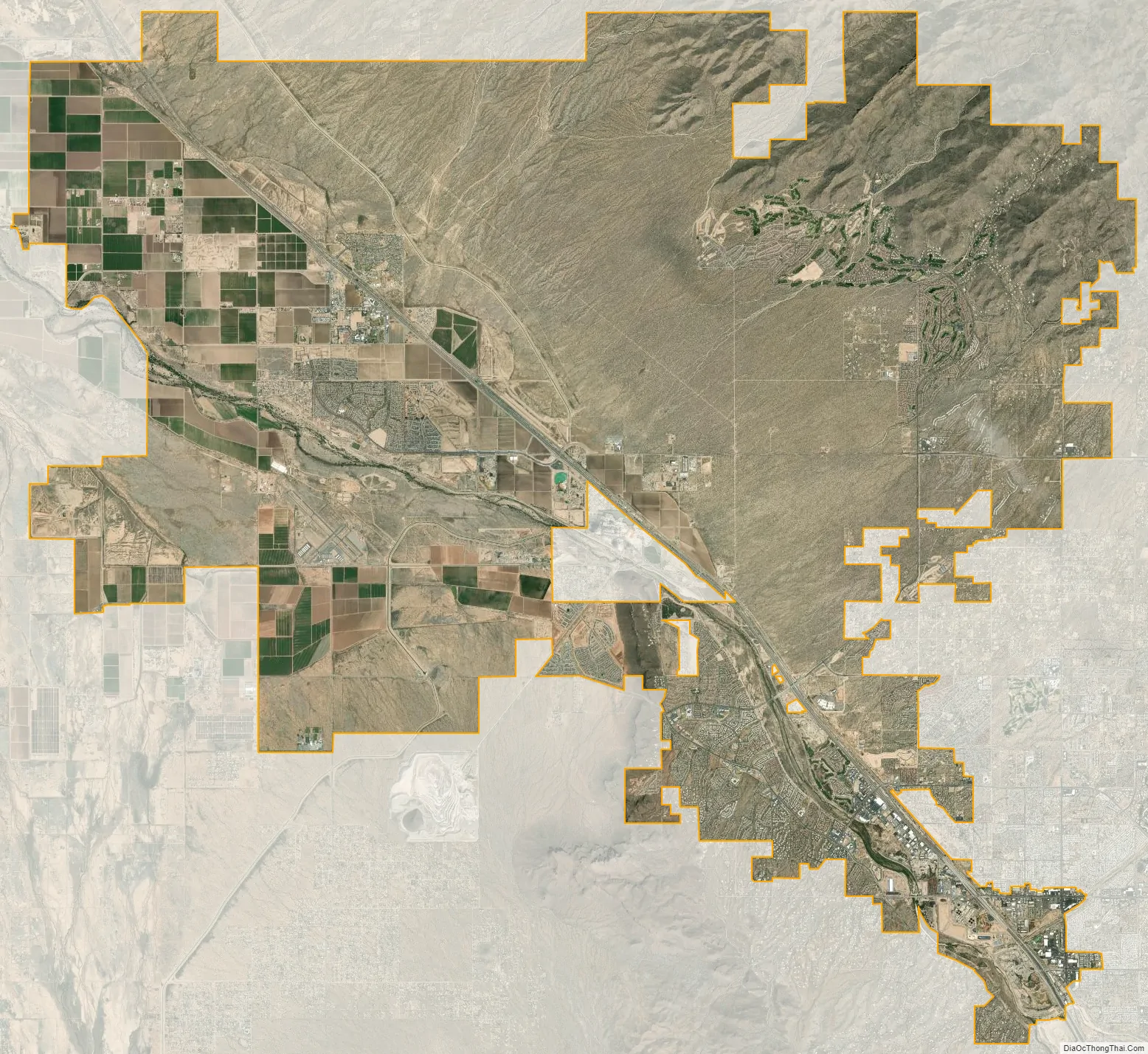
Marana Road Map

Marana city Satellite Map
Geography
Marana is located at 32°23′12″N 111°7′32″W / 32.38667°N 111.12556°W / 32.38667; -111.12556 (32.386539, -111.125437).
According to the United States Census Bureau, the town has a total area of 121.4 square miles (313.6 km), of which 120.7 square miles (312.3 km) is land and 0.7 square miles (1.9 km) (1.22%) is water.
The town extends along Interstate 10 from the line between Pinal and Pima counties to the Tucson city line, except for the area around the non-affluent unincorporated community of Rillito. The town has a history of farming and ranching. Marana is located in the Sonoran Desert and is surrounded by the Tortolita Mountains, the Santa Catalina Mountains, and the Tucson Mountains.
The Tucson Mountains and the western half of Saguaro National Park are located to the south. Phoenix is approximately 90 minutes north via Interstate 10.
See also
Map of Arizona State and its subdivision: Map of other states:- Alabama
- Alaska
- Arizona
- Arkansas
- California
- Colorado
- Connecticut
- Delaware
- District of Columbia
- Florida
- Georgia
- Hawaii
- Idaho
- Illinois
- Indiana
- Iowa
- Kansas
- Kentucky
- Louisiana
- Maine
- Maryland
- Massachusetts
- Michigan
- Minnesota
- Mississippi
- Missouri
- Montana
- Nebraska
- Nevada
- New Hampshire
- New Jersey
- New Mexico
- New York
- North Carolina
- North Dakota
- Ohio
- Oklahoma
- Oregon
- Pennsylvania
- Rhode Island
- South Carolina
- South Dakota
- Tennessee
- Texas
- Utah
- Vermont
- Virginia
- Washington
- West Virginia
- Wisconsin
- Wyoming