Map of Munday city
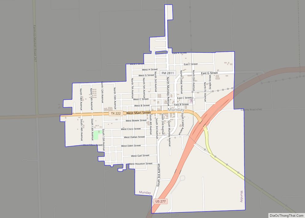
Munday (/ˈmʌndi/ MUN-dee) is a city in Knox County, Texas, United States. The population was 1,246 at the 2020 census. Munday city overview: Name: Munday city LSAD Code: 25 LSAD Description: city (suffix) State: Texas County: Knox County Elevation: 1,480 ft (451 m) Total Area: 1.43 sq mi (3.70 km²) Land Area: 1.43 sq mi (3.70 km²) Water Area: 0.00 sq mi (0.00 km²) Total Population: ... Read more
Map of Munday city
Map of Mullin town
Mullin is a town in Mills County in Northwestern Central Texas. The population was 179 at the 2010 census. Mullin town overview: Name: Mullin town LSAD Code: 43 LSAD Description: town (suffix) State: Texas County: Mills County Elevation: 1,437 ft (438 m) Total Area: 0.47 sq mi (1.21 km²) Land Area: 0.47 sq mi (1.21 km²) Water Area: 0.00 sq mi (0.00 km²) Total Population: −3 ... Read more
Map of Mullin town
Map of Muleshoe city
Muleshoe is a city in Bailey County, Texas, United States. It was founded in 1913, when the Pecos and Northern Texas Railway built an 88-mile (142 km) line from Farwell, Texas, to Lubbock through northern Bailey County. In 1926, Muleshoe was incorporated. Its population was 5,158 at the 2010 census. The county seat of Bailey County, ... Read more
Map of Muleshoe city
Map of Muenster city
Muenster (/ˈmʌnstər/ MUN-stər) is a city in western Cooke County, Texas, United States, along U.S. Route 82. The population was 1,544 at the 2010 census. Muenster is a primarily German-Texan and Catholic city. Muenster city overview: Name: Muenster city LSAD Code: 25 LSAD Description: city (suffix) State: Texas County: Cooke County Elevation: 1,001 ft (305 m) Total ... Read more
Map of Muenster city
Map of Mountain City, Texas
Mountain City is a city in Hays County, Texas, United States. The population was 648 at the 2010 census. From the early 1850s until the 1880s, Mountain City was a sprawling community on the old Stagecoach Road that served as an important hub in the ranching and farming industries of the newly formed Hays County. ... Read more
Map of Mountain City, Texas
Map of Mustang Ridge city
Mustang Ridge is a city in Caldwell, Bastrop, and Travis Counties in the U.S. state of Texas. The population was 944 at the 2020 census. Mustang Ridge city overview: Name: Mustang Ridge city LSAD Code: 25 LSAD Description: city (suffix) State: Texas County: Bastrop County, Caldwell County, Travis County Elevation: 623 ft (190 m) Total Area: 3.73 sq mi ... Read more
Map of Mustang Ridge city
Map of Murphy city, Texas
Murphy is a city in suburban Collin County, Texas, United States. The 2020 census reported the population as 21,013, compared to 3,099 in 2000. Murphy is located northeast of Dallas and has a history that goes back to the late 1800s. Murphy city overview: Name: Murphy city LSAD Code: 25 LSAD Description: city (suffix) State: ... Read more
Map of Murphy city, Texas
Map of Murillo CDP
Murillo, previously recorded as Nurillo, is a census-designated place (CDP) in Hidalgo County, Texas, United States. The population was 7,344 at the 2010 census, up from 5,056 at the 2000 census. It is part of the McAllen–Edinburg–Mission Metropolitan Statistical Area. Murillo CDP overview: Name: Murillo CDP LSAD Code: 57 LSAD Description: CDP (suffix) State: Texas ... Read more
Map of Murillo CDP
Map of Navasota city
Navasota is a city in Grimes County, Texas, United States. The population was 7,643 at the 2020 census. In 2005, the Texas Legislature designated Navasota as the “Blues Capital of Texas” in honor of the late Mance Lipscomb, a Navasota native and blues musician. Navasota city overview: Name: Navasota city LSAD Code: 25 LSAD Description: ... Read more
Map of Navasota city
Map of Navarro town
Navarro (/nəˈværoʊ/ nə-VARR-oh) is a town in Navarro County, Texas, United States. The population was 210 at the 2010 census. Navarro town overview: Name: Navarro town LSAD Code: 43 LSAD Description: town (suffix) State: Texas County: Navarro County Elevation: 417 ft (127 m) Total Area: 0.67 sq mi (1.73 km²) Land Area: 0.67 sq mi (1.73 km²) Water Area: 0.00 sq mi (0.00 km²) Total Population: ... Read more
Map of Navarro town
Map of Natalia city
Natalia is a city in Medina County, Texas, United States. The population was 1,202 at the 2020 census. It was founded in 1912 and was named after Natalie Pearson Nicholson, daughter of Frederick Stark Pearson, engineer, designer and builder of the Medina Dam. Natalia is part of the San Antonio Metropolitan Statistical Area. Natalia city ... Read more
Map of Natalia city
Map of Nassau Bay city
Nassau Bay is a city in Harris County, Texas, United States, bordering the outermost southeastern edge of the city of Houston. It is located in the Clear Lake Area near Galveston Bay, directly adjacent to the Lyndon B. Johnson Space Center. The population was 5,347 at the 2020 census. Nassau Bay city overview: Name: Nassau ... Read more
Map of Nassau Bay city