Map of New Fairview city
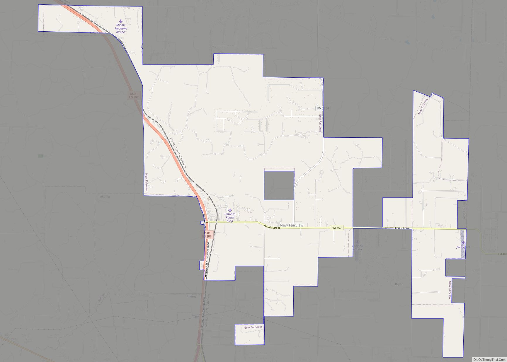
New Fairview is a city in Wise County, Texas, United States. The population was 1,386 in 2020. Growing from a settlement called Illinois Community, the city was called Fairview until 1999, when it was changed to distinguish it from several other Fairviews in Texas. In order to maintain a quieter, more rural atmosphere, residential lots ... Read more
Map of New Fairview city
Map of New Deal town, Texas
New Deal is a U.S. town in Lubbock County, Texas. The population was 794 at the 2010 census. It is part of the Lubbock Metropolitan Statistical Area and the Llano Estacado region. New Deal town overview: Name: New Deal town LSAD Code: 43 LSAD Description: town (suffix) State: Texas County: Lubbock County Elevation: 3,300 ft (1,000 m) ... Read more
Map of New Deal town, Texas
Map of Noonday city
Noonday is a city in Smith County, Texas, United States. The population was 612 at the 2020 census. It is part of the Tyler, Texas Metropolitan Statistical Area. Noonday is perhaps best known for the “Noonday Onion,” reputed to be one of the sweetest onions available. An onion must be grown within a ten-mile radius ... Read more
Map of Noonday city
Map of Nome city, Texas
Nome is a city in Jefferson County and Liberty County, Texas, United States. It is located 20 miles west of Beaumont at the intersection of U.S. Highway 90, State Highway 326 and Farm to Market Road 365. The population was 469 at the 2020 census. It is part of the Beaumont–Port Arthur Metropolitan Statistical Area. ... Read more
Map of Nome city, Texas
Map of Nolanville city
Nolanville is a city in Bell County, Texas, United States. The population was 5,917 at the 2020 census. It is part of the Killeen–Temple–Fort Hood Metropolitan Statistical Area. Nolanville city overview: Name: Nolanville city LSAD Code: 25 LSAD Description: city (suffix) State: Texas County: Bell County Elevation: 709 ft (216 m) Total Area: 4.27 sq mi (11.06 km²) Land Area: ... Read more
Map of Nolanville city
Map of Nocona city
Nocona is a city along U.S. Highway 82 and State Highway 175 in Montague County, Texas, United States. The population was 3,033 at the 2010 census. The city, its lake, and its resurgence as a regional travel destination were featured in the June 2012 edition of Texas Highways magazine. Nocona city overview: Name: Nocona city ... Read more
Map of Nocona city
Map of Nocona Hills CDP
Nocona Hills is an unincorporated community and census-designated place in Montague County, Texas, United States. Its population was 675 as of the 2010 census. Nocona Hills CDP overview: Name: Nocona Hills CDP LSAD Code: 57 LSAD Description: CDP (suffix) State: Texas County: Montague County Elevation: 909 ft (277 m) Total Area: 6.306 sq mi (16.33 km²) Land Area: 5.205 sq mi (13.48 km²) ... Read more
Map of Nocona Hills CDP
Map of Nixon city, Texas
Nixon is a city, self-described as a “compact neighborhood,” at U.S. Highway 87 and the junction of Karnes, Gonzales and Wilson counties; alongside the Clear Fork Creek in the Juan J. Tejada League, in the U.S. state of Texas. Approaching 100 city blocks, the Nixon urban-area is defined by its schools at its north-end in ... Read more
Map of Nixon city, Texas
Map of Nina CDP
Nina is a census-designated place (CDP) in Starr County, Texas, United States. This was a new CDP for the 2010 census with a population of 141. Nina CDP overview: Name: Nina CDP LSAD Code: 57 LSAD Description: CDP (suffix) State: Texas County: Starr County Total Area: 141 FIPS code: 4851552 Online Interactive Map Nina online ... Read more
Map of Nina CDP
Map of Niederwald city
Niederwald is a city in Caldwell and Hays counties in the U.S. state of Texas. The population was 565 at the 2010 census. Niederwald means “low forest”, or “low wood”, in German. It was named Niederwald by the German founders of the town. This region of Central Texas was settled in the 1800s primarily by ... Read more
Map of Niederwald city
Map of Neylandville town
Neylandville is a town in Hunt County, Texas, United States. The population was 97 at the 2010 census, up from 56 at the 2000 census. Neylandville town overview: Name: Neylandville town LSAD Code: 43 LSAD Description: town (suffix) State: Texas County: Hunt County Elevation: 535 ft (163 m) Total Area: 0.32 sq mi (0.82 km²) Land Area: 0.32 sq mi (0.82 km²) Water ... Read more
Map of Neylandville town
Map of Newton city, Texas
Newton is a city in and the county seat of Newton County, Texas, United States. The population was 1,633 at the 2020 census. Newton city overview: Name: Newton city LSAD Code: 25 LSAD Description: city (suffix) State: Texas County: Newton County Elevation: 194 ft (59 m) Total Area: 5.46 sq mi (14.13 km²) Land Area: 5.45 sq mi (14.10 km²) Water Area: 0.01 sq mi ... Read more
Map of Newton city, Texas