Map of White Settlement city
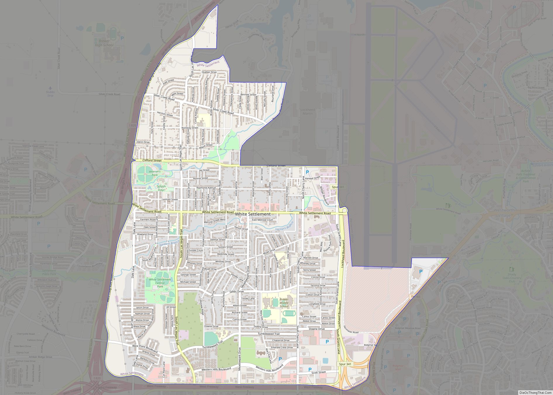
White Settlement is a city in Tarrant County, Texas, United States, and a northwestern suburb of Fort Worth. The population was 17,851 in 2019. White Settlement city overview: Name: White Settlement city LSAD Code: 25 LSAD Description: city (suffix) State: Texas County: Tarrant County Elevation: 666 ft (203 m) Total Area: 5.04 sq mi (13.05 km²) Land Area: 5.04 sq mi (13.05 km²) ... Read more
Map of White Settlement city
Map of Wildwood CDP, Texas
Wildwood is a gated community and census-designated place in Hardin and Tyler counties, Texas, United States. As of the 2020 census it had a population of 1,121. The Hardin county portion of Wildwood is part of the Beaumont–Port Arthur Metropolitan Statistical Area. Wildwood CDP overview: Name: Wildwood CDP LSAD Code: 57 LSAD Description: CDP (suffix) ... Read more
Map of Wildwood CDP, Texas
Map of Wild Peach Village CDP
Wild Peach Village is a census-designated place (CDP) in Brazoria County, Texas, United States. The population was 2,329 at the 2020 census. Wild Peach Village CDP overview: Name: Wild Peach Village CDP LSAD Code: 57 LSAD Description: CDP (suffix) State: Texas County: Brazoria County Elevation: 26 ft (8 m) Total Area: 10.0 sq mi (25.9 km²) Land Area: 10.0 sq mi (25.9 km²) ... Read more
Map of Wild Peach Village CDP
Map of Wickett town
Wickett is a town in Ward County, Texas, United States. The population was 498 at the 2010 census. Wickett town overview: Name: Wickett town LSAD Code: 43 LSAD Description: town (suffix) State: Texas County: Ward County Elevation: 2,667 ft (813 m) Total Area: 0.70 sq mi (1.82 km²) Land Area: 0.70 sq mi (1.82 km²) Water Area: 0.00 sq mi (0.00 km²) Total Population: 498 Population ... Read more
Map of Wickett town
Map of Wichita Falls city
Wichita Falls (/ˈwɪtʃɪtɑː/ WITCH-i-tah) is a city in and the seat of government of Wichita County, Texas, United States. It is the principal city of the Wichita Falls metropolitan statistical area, which encompasses all of Archer, Clay, and Wichita counties. According to the 2010 census, it had a population of 104,553, making it the 38th-most ... Read more
Map of Wichita Falls city
Map of Winfield city, Texas
Winfield is a small city in Titus County, Texas, United States. The population was 524 at the 2010 census. Winfield city overview: Name: Winfield city LSAD Code: 25 LSAD Description: city (suffix) State: Texas County: Titus County Elevation: 456 ft (139 m) Total Area: 0.79 sq mi (2.04 km²) Land Area: 0.78 sq mi (2.01 km²) Water Area: 0.01 sq mi (0.03 km²) Total Population: 524 ... Read more
Map of Winfield city, Texas
Map of Windthorst town
Windthorst is a town in Archer and Clay counties in the U.S. state of Texas. It is part of the Wichita Falls, Texas Metropolitan Statistical Area. The population was 409 at the 2010 census. The town is named for Ludwig Windthorst, a Catholic statesman in Germany. Windthorst is the home of the St. Mary’s Grotto, ... Read more
Map of Windthorst town
Map of Windom town, Texas
Windom is a town in Fannin County, Texas, United States. The population was 199 at the 2010 census, down from 245 at the 2000 census. Windom town overview: Name: Windom town LSAD Code: 43 LSAD Description: town (suffix) State: Texas County: Fannin County Elevation: 696 ft (212 m) Total Area: 0.55 sq mi (1.43 km²) Land Area: 0.55 sq mi (1.43 km²) Water ... Read more
Map of Windom town, Texas
Map of Windcrest city
Windcrest is a city in Bexar County, Texas, United States. Its population was 5,865 at the 2020 census. It is part of the San Antonio metropolitan area. Windcrest city overview: Name: Windcrest city LSAD Code: 25 LSAD Description: city (suffix) State: Texas County: Bexar County Elevation: 791 ft (241 m) Total Area: 2.15 sq mi (5.58 km²) Land Area: 2.15 sq mi ... Read more
Map of Windcrest city
Map of Wimberley city
Wimberley is a village in Hays County, Texas, United States. It is still predominantly a ranching area outside of town. The population was 2,839 at the 2020 census. Wimberley city overview: Name: Wimberley city LSAD Code: 25 LSAD Description: city (suffix) State: Texas County: Hays County Elevation: 860 ft (262 m) Total Area: 8.96 sq mi (23.19 km²) Land Area: ... Read more
Map of Wimberley city
Map of Wilson city, Texas
Wilson is a small rural city in the northeastern quadrant of Lynn County, Texas, United States. As of the 2010 census, the population was 489. Wilson city overview: Name: Wilson city LSAD Code: 25 LSAD Description: city (suffix) State: Texas County: Lynn County Elevation: 3,120 ft (950 m) Total Area: 0.65 sq mi (1.67 km²) Land Area: 0.64 sq mi (1.67 km²) Total ... Read more
Map of Wilson city, Texas
Map of Wilmer city
Wilmer is a city in Dallas County, Texas, United States. The population was 3,682 at the 2010 census. It is part of the Dallas–Fort Worth–Arlington Metropolitan Statistical Area. Wilmer city overview: Name: Wilmer city LSAD Code: 25 LSAD Description: city (suffix) State: Texas County: Dallas County Elevation: 466 ft (142 m) Total Area: 6.40 sq mi (16.57 km²) Land Area: ... Read more
Map of Wilmer city