Map of Independence town, Utah
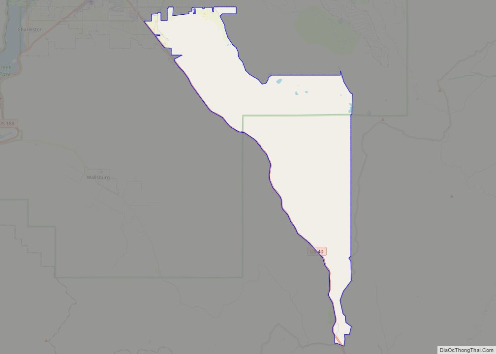
Independence is a town in Wasatch County, Utah, United States. Lying just east of U.S. Route 40 southeast of Heber City, Independence was incorporated in 2008 under a controversial, short-lived state law. The population was 164 at the 2010 census. Independence town overview: Name: Independence town LSAD Code: 43 LSAD Description: town (suffix) State: Utah ... Read more
Map of Independence town, Utah
Map of Kanarraville town
Kanarraville (/kəˈnærəvɪl/ kə-NARR-ə-vil) is a town in Iron County, Utah, United States. The population was 355 at the 2010 census. Kanarraville town overview: Name: Kanarraville town LSAD Code: 43 LSAD Description: town (suffix) State: Utah County: Iron County Incorporated: 1933 Elevation: 5,541 ft (1,689 m) Total Area: 0.45 sq mi (1.15 km²) Land Area: 0.45 sq mi (1.15 km²) Water Area: 0.00 sq mi (0.00 km²) ... Read more
Map of Kanarraville town
Map of Kanab city
Kanab (/kəˈnæb/ kə-NAB) is a city in and the county seat of Kane County, Utah, United States. It is located on Kanab Creek just north of the Arizona state line. This area was first settled in 1864, and the town was founded in 1870 when ten Mormon families moved into the area. Named for a ... Read more
Map of Kanab city
Map of Kamas city
Kamas (/ˈkæməs/ KAM-əs) is a city in southwestern Summit County, Utah, United States. The population was 1,811 at the 2010 census. It is located 42 miles (68 km) east of downtown Salt Lake City. The main industries are cattle ranching and lumber. The town is known as “The Gateway to the Uinta Mountains”. Kamas city overview: ... Read more
Map of Kamas city
Map of Laketown town
Laketown is a town in Rich County, Utah, United States. The population was 248 at the 2010 census. The town is named for nearby Bear Lake. Laketown town overview: Name: Laketown town LSAD Code: 43 LSAD Description: town (suffix) State: Utah County: Rich County Incorporated: July 1945 Elevation: 5,974 ft (1,821 m) Total Area: 2.53 sq mi (6.56 km²) Land ... Read more
Map of Laketown town
Map of Lake Shore CDP, Utah
Lake Shore is a census-designated place (CDP) in Utah County, Utah, United States. It is part of the Provo–Orem Metropolitan Statistical Area. The population was 817 at the 2010 census. Lake Shore CDP overview: Name: Lake Shore CDP LSAD Code: 57 LSAD Description: CDP (suffix) State: Utah County: Utah County Elevation: 4,521 ft (1,378 m) Total Area: ... Read more
Map of Lake Shore CDP, Utah
Map of La Verkin city
La Verkin is a city in Washington County, Utah, United States. The population was 4,060 as of 2010, an increase from 3,392 in 2000. La Verkin is within walking distance of Hurricane, and the two cities have historically had close ties. Theories about the origin of the city’s name suggest that it may be a ... Read more
Map of La Verkin city
Map of La Sal CDP
La Sal is a census-designated place (CDP) in northeastern San Juan County, Utah, United States. The population was 339 at the 2000 census. The name comes from the La Sal Mountains which means in Spanish “The Salt”. The area is known for its uranium resources. La Sal CDP overview: Name: La Sal CDP LSAD Code: ... Read more
Map of La Sal CDP
Map of Koosharem town
Koosharem is a town in Sevier County, Utah, United States. Koosharem is also known as “Grass Valley”. It generally comprises the area known as Burrville, Utah on the north, south through the valley and through the town of Koosharem and down to the south end with the town of Greenwich, Utah. The valley is made ... Read more
Map of Koosharem town
Map of Kingston town, Utah
Kingston is a town in Piute County, Utah, United States. The population was 135 at the 2020 census. Kingston town overview: Name: Kingston town LSAD Code: 43 LSAD Description: town (suffix) State: Utah County: Piute County Incorporated: 1935 Elevation: 6,017 ft (1,834 m) Total Area: 5.40 sq mi (13.99 km²) Land Area: 5.40 sq mi (13.99 km²) Water Area: 0.00 sq mi (0.00 km²) Total Population: ... Read more
Map of Kingston town, Utah
Map of Kenilworth CDP, Utah
Kenilworth is a census-designated place in northern Carbon County, Utah, United States. Kenilworth CDP overview: Name: Kenilworth CDP LSAD Code: 57 LSAD Description: CDP (suffix) State: Utah County: Carbon County Founded: 1908 Elevation: 6,316 ft (1,925 m) Total Area: 0.75 sq mi (1.95 km²) Land Area: 0.75 sq mi (1.95 km²) Water Area: 0.0 sq mi (0.0 km²) Total Population: 180 Population Density: 239/sq mi (92.4/km²) FIPS ... Read more
Map of Kenilworth CDP, Utah
Map of Kearns metro township
Kearns (/kɜːrnz/ kurnz) is a metro township in Salt Lake County, Utah, United States. Named after Utah’s U.S. Senator Thomas Kearns, it had a population of 36,723 at the 2020 Census. This was a 2.8 percent increase over the 2010 figure of 35,731. Kearns is home to the Utah Olympic Oval, an indoor speed skating ... Read more
Map of Kearns metro township