Kearns (/kɜːrnz/ kurnz) is a metro township in Salt Lake County, Utah, United States. Named after Utah’s U.S. Senator Thomas Kearns, it had a population of 36,723 at the 2020 Census. This was a 2.8 percent increase over the 2010 figure of 35,731. Kearns is home to the Utah Olympic Oval, an indoor speed skating oval built for the 2002 Winter Olympics.
| Name: | Kearns metro township |
|---|---|
| LSAD Code: | 35 |
| LSAD Description: | metro township |
| State: | Utah |
| County: | Salt Lake County |
| Founded: | 1 May 1942 |
| Elevation: | 4,528 ft (1,380 m) |
| Total Area: | 4.63 sq mi (11.99 km²) |
| Land Area: | 4.63 sq mi (11.99 km²) |
| Water Area: | 0.00 sq mi (0.00 km²) |
| Total Population: | 36,723 |
| Population Density: | 7,931.53/sq mi (3,062.38/km²) |
| ZIP code: | 84118 |
| Area code: | 385, 801 |
| FIPS code: | 4940470 |
| GNISfeature ID: | 1429290 |
| Website: | https://www.kmtutah.org/ |
Online Interactive Map
Click on ![]() to view map in "full screen" mode.
to view map in "full screen" mode.
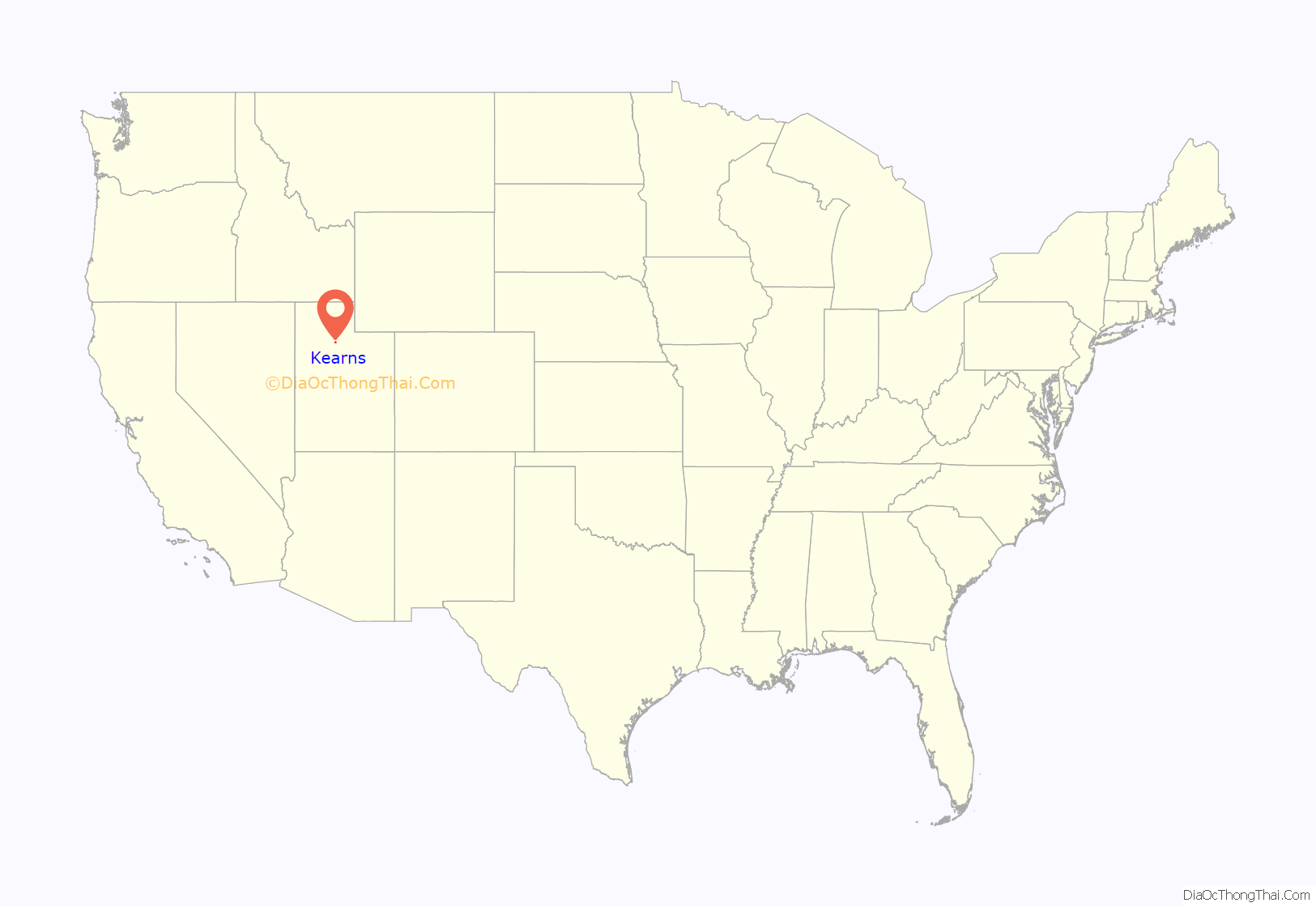
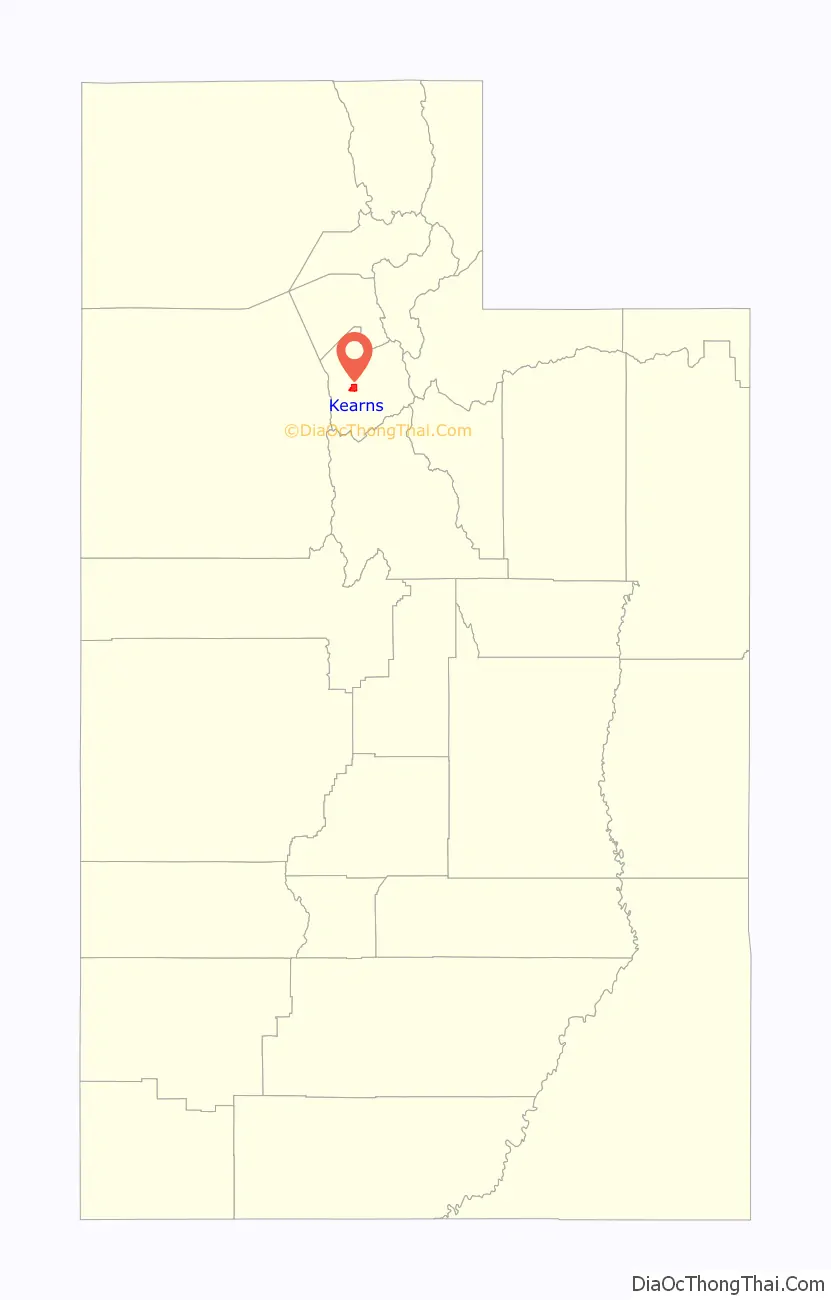
Kearns location map. Where is Kearns metro township?
History
World War II
Kearns came into existence 1 May 1942 as a World War II United States Army Air Forces training facility known as Kearns Army Air Base (also known as Kearns Center; redesignated: Camp Kearns, 1 January 1944). Before the base was built, the area consisted of dry farms on land reserved for universities and colleges. Construction of the base involved building airplane runways and hangars, with several taxiways and a large parking apron and a control tower. Several hundred buildings were also constructed and quickly assembled. Most base buildings, not meant for long-term use, were constructed of temporary or semi-permanent materials. Most support buildings sat on concrete foundations but were of frame construction clad in little more than plywood and tarpaper. The thousands of soldiers and airmen stationed there temporarily made the base one of the largest cities in the state. On 15 August 1946, the Air Force deactivated the base and turned the facility over to the State of Utah. The presence of roads and other infrastructure made the area attractive to developers. Houses and businesses sprang up rapidly on what had just a few years earlier been farmland. A theater for “colored personnel” became part of Kearns Junior High School. A base chapel is now part of Our Lady of Perpetual Help Catholic Church. The base train station is a day-care center. A cannon that had stood next to the headquarters’ flagpole stood for many years at the corner of 40th West and 54th South. The airfield part of Kearns Army Air Base today is known as South Valley Regional Airport.
Post war and turn of the century
Kearns, in the mid to late twentieth century, saw rapid growth on the former airbase. The old streets and foundations of buildings built by the military were used as a template for the town, and homes sprang up quickly as Kearns was becoming the first suburb in Salt Lake County. By the 1970s and into the 1980s, suburban development expanded west of the railroad tracks to 5600 West. In the 1990s there were arguments between the residents of Kearns, West Valley City, and West Jordan city over annexation. West Valley City began annexing land west of Kearns and cut the community from future development. West Jordan annexed the Oquirrh Shadows subdivision and the remaining land became the Oquirrh CDP. In the late 1990s West Valley City and West Jordan were having talks to divide what was left of Kearns to divide the community along 5400 south where anything south of the road would belong to West Jordan and anything North would belong to West Valley City. The residents of Kearns raised enough signatures to stop the annexation and leave Kearns’ boundaries as they are today. In 2002, the Winter Olympics brought construction of the Olympic Oval at Oquirrh Park. The Olympic Oval was built on a former running track. The Utah Olympic Oval in Kearns was the venue for long-track speed skating events in the 2002 Winter Olympics. Because of its altitude, which gives it the thinnest air of any such facility in the world, and its unique architecture, which allows for close control of temperature and ice conditions, the Oval saw numerous records set during the games. It remains arguably the fastest ice surface in the world. It is used today as a tourist attraction and a recreation spot. The last major housing area constructed in Kearns was an area between 5600 west and 6200 south.
2005–present
In 2015 the township of Kearns voted to incorporate as a metro township, a new form of local government that allowed it to elect a council and mayor. Kearns could have also voted to become a city. The following year five council members were elected from five districts and took office in 2017. In 2019 and 2020 more housing was built around Oquirrh park and a new Kearns library was finished in December 2020. Every year in late July and early August there is a parade in Kearns.
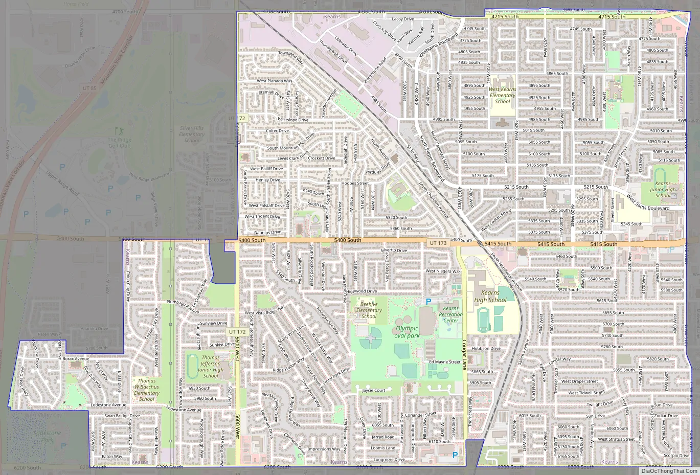
Kearns Road Map
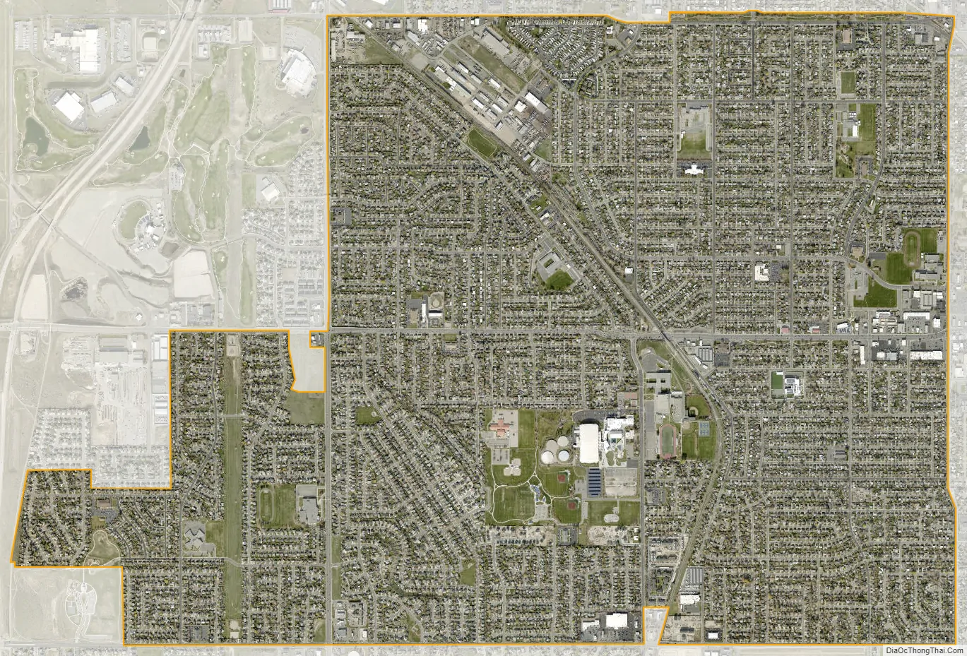
Kearns city Satellite Map
Geography
According to the United States Census Bureau, the Metro township has a total area of 4.63 square miles (12.0 km), all land.
Kearns lies on the western side of the Salt Lake Valley and West Bench. The majority of the township lies on the lake bed of the Provo episode of Lake Bonneville, while all of Kearns lies on the Bonneville lake bed. Kearns borders West Valley City to the north and west, Taylorsville to the east, and West Jordan to the south.
The area where Kearns is situated is on a natural formation called the Kearns-Benion hill, which rises approximately 100 feet (30 m) above the valley. The hill runs in a northwest direction from the Jordan River to Bacchus hill in the Oquirrh Mountains.
Climate
This climatic region is typified by large seasonal temperature differences, with warm to hot (usually dry) summers and cold (sometimes severely cold) winters. According to the Köppen Climate Classification system, Kearns has a humid continental climate, abbreviated “Dfb” on climate maps.
See also
Map of Utah State and its subdivision: Map of other states:- Alabama
- Alaska
- Arizona
- Arkansas
- California
- Colorado
- Connecticut
- Delaware
- District of Columbia
- Florida
- Georgia
- Hawaii
- Idaho
- Illinois
- Indiana
- Iowa
- Kansas
- Kentucky
- Louisiana
- Maine
- Maryland
- Massachusetts
- Michigan
- Minnesota
- Mississippi
- Missouri
- Montana
- Nebraska
- Nevada
- New Hampshire
- New Jersey
- New Mexico
- New York
- North Carolina
- North Dakota
- Ohio
- Oklahoma
- Oregon
- Pennsylvania
- Rhode Island
- South Carolina
- South Dakota
- Tennessee
- Texas
- Utah
- Vermont
- Virginia
- Washington
- West Virginia
- Wisconsin
- Wyoming