Map of Harriston CDP
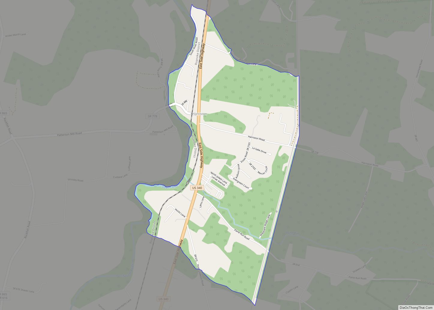
Harriston is a census-designated place in Augusta County, Virginia. The population as of the 2010 Census was 909. Harriston CDP overview: Name: Harriston CDP LSAD Code: 57 LSAD Description: CDP (suffix) State: Virginia County: Augusta County Total Area: 909 ZIP code: 24441 FIPS code: 5135640 GNISfeature ID: 2630778 Online Interactive Map Harriston online map. Source: ... Read more
Map of Harriston CDP
Map of Harborton CDP
Harborton is a census-designated place (CDP) in Accomack County, Virginia, United States. Per the 2020 census, the population was 130. Harborton CDP overview: Name: Harborton CDP LSAD Code: 57 LSAD Description: CDP (suffix) State: Virginia County: Accomack County Elevation: 2 m (7 ft) Total Area: 130 FIPS code: 5135240 GNISfeature ID: 2584855 Online Interactive Map Harborton online ... Read more
Map of Harborton CDP
Map of Hanover CDP, Virginia
Hanover CDP overview: Name: Hanover CDP LSAD Code: 57 LSAD Description: CDP (suffix) State: Virginia County: Hanover County FIPS code: 5135160 Online Interactive Map Hanover online map. Source: Basemap layers from Google Map, Open Street Map (OSM), Arcgisonline, Wmflabs. Boundary Data from Database of Global Administrative Areas. Hanover location map. Where is Hanover CDP? Hanover ... Read more
Map of Hanover CDP, Virginia
Map of Hampden-Sydney CDP
Hampden Sydney is a census-designated place (CDP) in Prince Edward County, Virginia, United States. The population was 1,450 at the 2010 census. Hampden Sydney is the home of Hampden–Sydney College, a private all-male college that is the tenth-oldest institution of higher education in the United States. Hampden-Sydney CDP overview: Name: Hampden-Sydney CDP LSAD Code: 57 ... Read more
Map of Hampden-Sydney CDP
Map of Hallwood town
Hallwood is a town in Accomack County, Virginia, in the United States. As of the 2010 census, the town population was 206. Hallwood town overview: Name: Hallwood town LSAD Code: 43 LSAD Description: town (suffix) State: Virginia County: Accomack County Elevation: 16 ft (5 m) Total Area: 0.24 sq mi (0.61 km²) Land Area: 0.24 sq mi (0.61 km²) Water Area: 0.00 sq mi (0.00 km²) ... Read more
Map of Hallwood town
Map of Halifax town, Virginia
Halifax is a town in Halifax County, Virginia, United States, along the Banister River. The population was 1,309 at the 2010 census. It is the county seat of Halifax County. Halifax town overview: Name: Halifax town LSAD Code: 43 LSAD Description: town (suffix) State: Virginia County: Halifax County Elevation: 495 ft (151 m) Total Area: 3.83 sq mi (9.92 km²) ... Read more
Map of Halifax town, Virginia
Map of Heathsville CDP
Heathsville is a census-designated place (CDP) in and the county seat of Northumberland County, Virginia, United States. Heathsville is in the easternmost county of the Northern Neck of Virginia, which was the birthplace of three of the first five Presidents of the United States – George Washington, James Madison, and James Monroe. It is the ... Read more
Map of Heathsville CDP
Map of Honaker town
Honaker is a town in Russell County, Virginia, United States. The population was 1,449 at the 2010 census. Honaker town overview: Name: Honaker town LSAD Code: 43 LSAD Description: town (suffix) State: Virginia County: Russell County Elevation: 1,870 ft (570 m) Total Area: 1.68 sq mi (4.34 km²) Land Area: 1.68 sq mi (4.34 km²) Water Area: 0.00 sq mi (0.00 km²) Total Population: 1,449 Population ... Read more
Map of Honaker town
Map of Hillsville town
Hillsville is a town in Carroll County, Virginia, United States. The population was 2,897 at the 2020 census. It is the county seat of Carroll County. Hillsville town overview: Name: Hillsville town LSAD Code: 43 LSAD Description: town (suffix) State: Virginia County: Carroll County Founded: 1842 Elevation: 2,516 ft (767 m) Total Area: 9.75 sq mi (25.25 km²) Land Area: ... Read more
Map of Hillsville town
Map of Hillsboro town, Virginia
Hillsboro is a rural town in Loudoun County, Virginia, United States. The population was 80 at the 2010 census and an estimated 169 as of 2019. Hillsboro town overview: Name: Hillsboro town LSAD Code: 43 LSAD Description: town (suffix) State: Virginia County: Loudoun County Elevation: 551 ft (168 m) Total Area: 0.27 sq mi (0.69 km²) Land Area: 0.27 sq mi (0.69 km²) ... Read more
Map of Hillsboro town, Virginia
Map of Herndon town, Virginia
Herndon is a town in Fairfax County, Virginia, in the Washington, D.C. metropolitan area of the United States. In 2020, the population was estimated to be 24,532, which makes it the largest of three incorporated towns in the county. The actual dimensions of the town of Herndon are fairly small. However, the United States Post ... Read more
Map of Herndon town, Virginia
Map of Idylwood CDP
Idylwood is a census-designated place (CDP) in Fairfax County, Virginia, United States. The population was 17,954 as of the 2020 census. It originally developed as a suburban community along the route of the Washington and Old Dominion Railroad, and later along Virginia State Route 7. The construction of the Capital Beltway in the 1960s, and ... Read more
Map of Idylwood CDP