Map of Independence town, Virginia
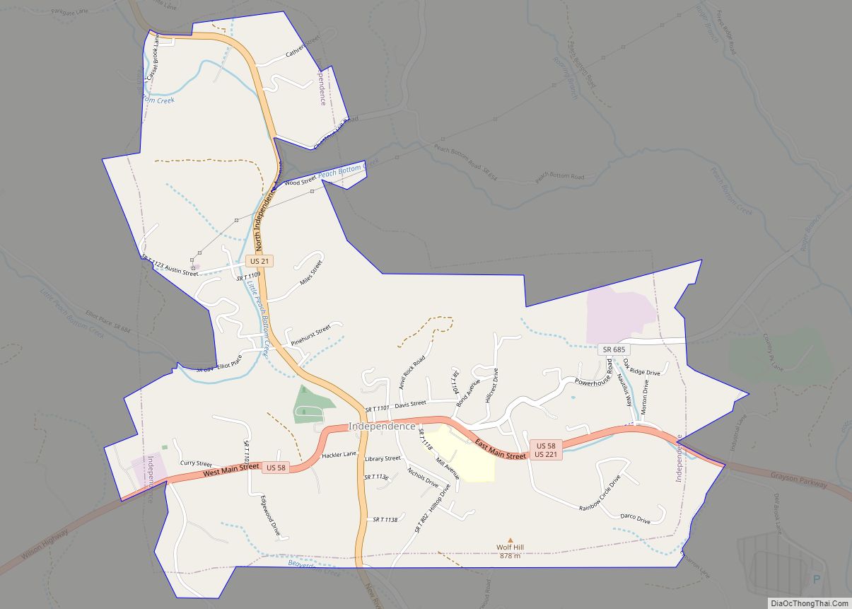
Independence is a town in Southwestern Virginia‘s Grayson County, with a population of 1,001 as of the 2020 census. As the Grayson County Seat, it is located 71 miles from Winston-Salem, North Carolina, the closest city with a population over 50,000, and is situated on Virginia’s Crooked Road, a heritage trail celebrating the musical heritage ... Read more
Map of Independence town, Virginia
Map of Idylwood CDP
Idylwood is a census-designated place (CDP) in Fairfax County, Virginia, United States. The population was 17,954 as of the 2020 census. It originally developed as a suburban community along the route of the Washington and Old Dominion Railroad, and later along Virginia State Route 7. The construction of the Capital Beltway in the 1960s, and ... Read more
Map of Idylwood CDP
Map of Hybla Valley CDP
Hybla Valley is a census-designated place (CDP) in Fairfax County, Virginia, United States, south of Alexandria. The population was 15,801 at the 2010 census, down from 16,721 in 2000 due to a reduction in area, resulting from some of the eastward neighborhoods including much of Hollin Hills being moved to the Fort Hunt CDP. The ... Read more
Map of Hybla Valley CDP
Map of Hurt town
Hurt is a town in Pittsylvania County, Virginia, United States. Population was 1,304 at the 2010 census. It is included in the Danville, Virginia Metropolitan Statistical Area. Hurt town overview: Name: Hurt town LSAD Code: 43 LSAD Description: town (suffix) State: Virginia County: Pittsylvania County Elevation: 748 ft (228 m) Total Area: 3.51 sq mi (9.10 km²) Land Area: 3.48 sq mi ... Read more
Map of Hurt town
Map of Huntington CDP, Virginia
Huntington is a census-designated place (CDP) in Fairfax County, Virginia, United States. The population was 11,267 at the 2010 census. It is located next to the southern border of the city of Alexandria and is part of the Washington metropolitan area. Its main component is the namesake Huntington subdivision, a late-1940s neighborhood of mainly duplex ... Read more
Map of Huntington CDP, Virginia
Map of Hot Springs CDP, Virginia
Hot Springs is a census-designated place (CDP) in Bath County, Virginia, United States. The population as of the 2010 Census was 738. It is located about 5 miles (8.0 kilometers) southwest of Warm Springs on U.S. Route 220. Hot Springs has several historic resorts, for the springs helped develop Bath County. Hot Springs CDP overview: ... Read more
Map of Hot Springs CDP, Virginia
Map of Horse Pasture CDP
Horse Pasture CDP overview: Name: Horse Pasture CDP LSAD Code: 57 LSAD Description: CDP (suffix) State: Virginia County: Henry County FIPS code: 5138552 Online Interactive Map Horse Pasture online map. Source: Basemap layers from Google Map, Open Street Map (OSM), Arcgisonline, Wmflabs. Boundary Data from Database of Global Administrative Areas. Horse Pasture location map. Where ... Read more
Map of Horse Pasture CDP
Map of Horntown CDP, Virginia
Horntown is a census-designated place (CDP) in Accomack County, Virginia, United States. Per the 2020 census, the population was 912. In the mid-19th-century, Horntown was a stagecoach stop on the route between Wilmington, Delaware and Eastville, Virginia. It lies at an elevation of 39 feet. Horntown CDP overview: Name: Horntown CDP LSAD Code: 57 LSAD ... Read more
Map of Horntown CDP, Virginia
Map of Kenbridge town
Kenbridge is a town in Lunenburg County, Virginia, United States. The population was 1,257 at the 2010 census. It is in a tobacco farming area. The area is home to noted folk artist Eldridge Bagley. Kenbridge town overview: Name: Kenbridge town LSAD Code: 43 LSAD Description: town (suffix) State: Virginia County: Lunenburg County Founded: 1908 ... Read more
Map of Kenbridge town
Map of Keller town, Virginia
Keller is a town in Accomack County, Virginia, United States. The population was 178 at the 2010 census. Keller town overview: Name: Keller town LSAD Code: 43 LSAD Description: town (suffix) State: Virginia County: Accomack County Elevation: 39 ft (12 m) Total Area: 0.34 sq mi (0.89 km²) Land Area: 0.34 sq mi (0.89 km²) Water Area: 0.00 sq mi (0.00 km²) Total Population: 178 Population ... Read more
Map of Keller town, Virginia
Map of Jonesville town, Virginia
Jonesville is a town in and the county seat of Lee County, Virginia, United States. The population was 1,034 at the 2010 census. Jonesville town overview: Name: Jonesville town LSAD Code: 43 LSAD Description: town (suffix) State: Virginia County: Lee County Elevation: 1,503 ft (458 m) Total Area: 1.11 sq mi (2.88 km²) Land Area: 1.11 sq mi (2.88 km²) Water Area: 0.00 sq mi ... Read more
Map of Jonesville town, Virginia
Map of Jolivue CDP
Jolivue CDP overview: Name: Jolivue CDP LSAD Code: 57 LSAD Description: CDP (suffix) State: Virginia County: Augusta County FIPS code: 5141144 Online Interactive Map Jolivue online map. Source: Basemap layers from Google Map, Open Street Map (OSM), Arcgisonline, Wmflabs. Boundary Data from Database of Global Administrative Areas. Jolivue location map. Where is Jolivue CDP? Jolivue ... Read more
Map of Jolivue CDP