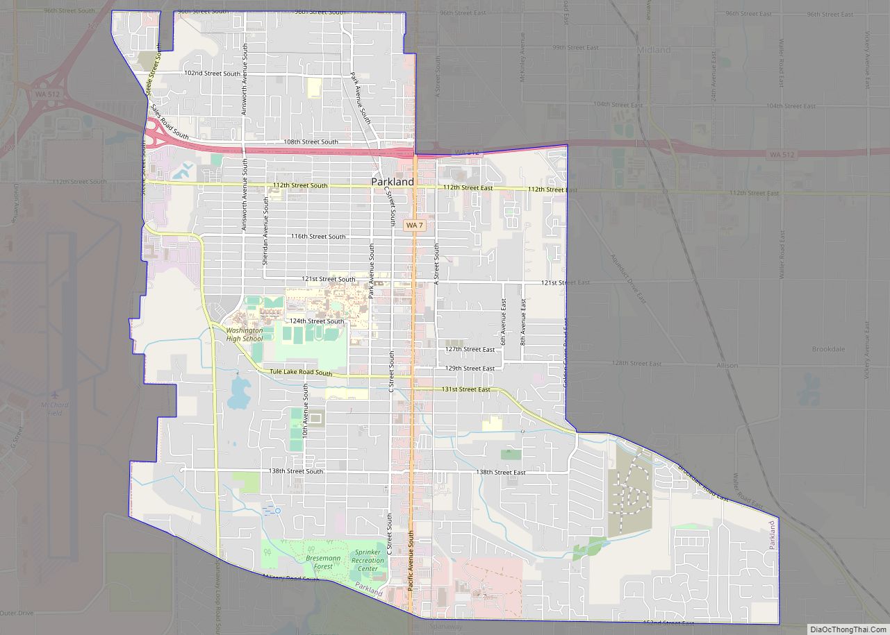
Parkland is a census-designated place (CDP) in Pierce County, Washington. The population was 35,803 at the time of the 2010 census and had grown to 38,623 as of the 2020 census. It is an unincorporated suburb of the city of Tacoma and is home to Pacific Lutheran University. Parkland borders most of Tacoma’s southern cutoff ... Read more
Map of US Cities and Places
Parker is a census-designated place and unincorporated community in central Yakima County, Washington, United States. It is located on U.S. Route 97 between the cities of Union Gap and Wapato on the Yakama Indian Reservation. The town had a population of 154 at the 2010 census. Parker CDP overview: Name: Parker CDP LSAD Code: 57 ... Read more
Palouse is a city in Whitman County, Washington, United States. The population was 998 at the 2010 census. Palouse city overview: Name: Palouse city LSAD Code: 25 LSAD Description: city (suffix) State: Washington County: Whitman County Elevation: 2,434 ft (742 m) Total Area: 1.05 sq mi (2.71 km²) Land Area: 1.05 sq mi (2.71 km²) Water Area: 0.00 sq mi (0.00 km²) Total Population: 998 Population ... Read more
Pacific is a city in King and Pierce counties in the State of Washington. Located primarily in King County, the population was 7,235 at the 2020 census. Pacific city overview: Name: Pacific city LSAD Code: 25 LSAD Description: city (suffix) State: Washington County: King County, Pierce County Elevation: 79 ft (24 m) Total Area: 2.44 sq mi (6.31 km²) Land ... Read more
Pacific Beach is a census-designated place (CDP) in Grays Harbor County, Washington, United States. The population was 291 at the 2010 census. Prior to 2010 it was part of the Moclips CDP. Pacific Beach CDP overview: Name: Pacific Beach CDP LSAD Code: 57 LSAD Description: CDP (suffix) State: Washington County: Grays Harbor County Elevation: 50 ft ... Read more
Oyehut is a census-designated place (CDP) in Grays Harbor County, Washington, United States. The population was 85 at the 2010 census. Prior to 2010 it was part of the combined Oyehut-Hogan’s Corner CDP. Oyehut CDP overview: Name: Oyehut CDP LSAD Code: 57 LSAD Description: CDP (suffix) State: Washington County: Grays Harbor County Elevation: 15 ft (5 m) ... Read more
Pomeroy is a city in Garfield County, Washington, United States. The population was 1,425 at the 2010 census. It is the county seat of and only incorporated city in Garfield County. Pomeroy city overview: Name: Pomeroy city LSAD Code: 25 LSAD Description: city (suffix) State: Washington County: Garfield County Elevation: 1,857 ft (566 m) Total Area: 1.78 sq mi ... Read more
Outlook is a census-designated place and unincorporated community in Yakima County, Washington, United States. Outlook is located along Interstate 82 and U.S. Route 12 4 miles (6.4 km) west of Sunnyside. Outlook has a post office with ZIP code 98938. Outlook CDP overview: Name: Outlook CDP LSAD Code: 57 LSAD Description: CDP (suffix) State: Washington County: ... Read more
Point Roberts is a pene-exclave of Washington on the southernmost tip of the Tsawwassen peninsula, south of Vancouver, British Columbia. The area, which had a population of 1,191 at the 2020 census, is reached by land from the rest of the United States by traveling 25 mi (40 km) through Canada. It is a census-designated place in ... Read more
Otis Orchards-East Farms is a census-designated place (CDP) in Spokane County, Washington, United States, near the county’s border with Idaho. The population was 6,299 at the 2020 census. The CDP includes the unincorporated communities of Otis Orchards and East Farms. Otis Orchards contains the bulk of the businesses of the community. Otis Orchards-East Farms is ... Read more
Pine Grove is a census-designated place located in Ferry County, Washington, United States. Pine Grove CDP overview: Name: Pine Grove CDP LSAD Code: 57 LSAD Description: CDP (suffix) State: Washington County: Ferry County Elevation: 2,579 ft (786 m) Total Area: 0.49 sq mi (1.27 km²) Land Area: 0.49 sq mi (1.27 km²) Water Area: 0.0 sq mi (0.0 km²) Total Population: 145 Population Density: 300/sq mi (110/km²) ... Read more
Picnic Point is a census-designated place (CDP) located in Snohomish County, Washington. The population was 8,809 at the 2010 census. It was formerly part of the Picnic Point-North Lynnwood CDP. Picnic Point CDP overview: Name: Picnic Point CDP LSAD Code: 57 LSAD Description: CDP (suffix) State: Washington County: Snohomish County Elevation: 79 ft (24 m) Total Area: ... Read more