Map of Merrill city, Wisconsin
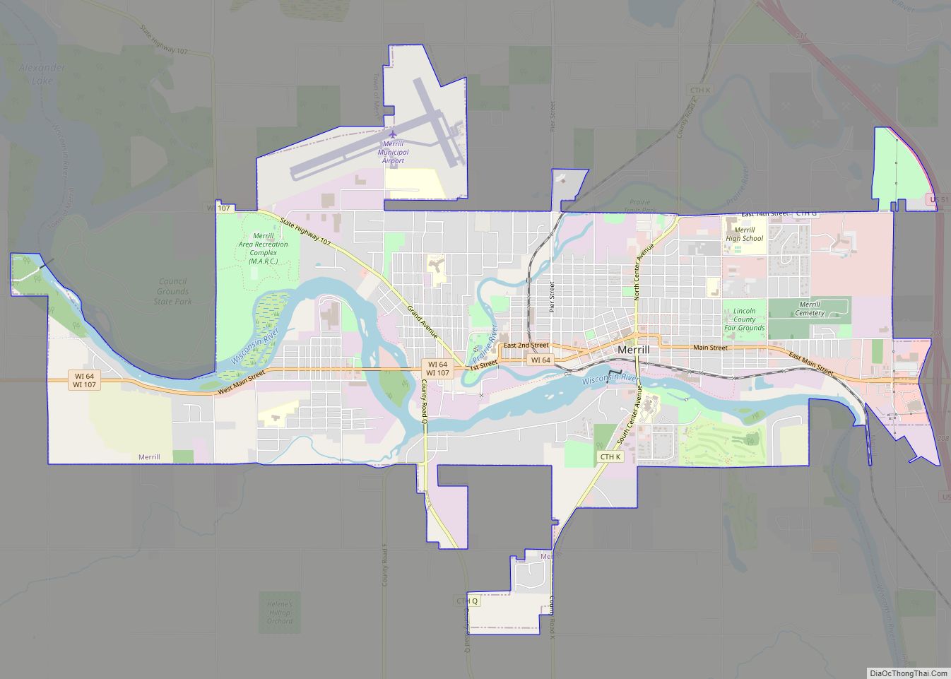
Merrill is a city in and the county seat of Lincoln County, Wisconsin, United States. It is located to the south of and adjacent to the Town of Merrill. The population was 9,347, according to the 2020 census. Merrill is part of the United States Census Bureau’s Merrill MSA, which includes all of Lincoln County. ... Read more
Map of Merrill city, Wisconsin
Map of Mercer CDP, Wisconsin
Mercer is an unincorporated census-designated place located in the town of Mercer, Iron County, Wisconsin, United States. Mercer is located on US Highway 51 (US 51) 20.5 miles (33.0 km) south-southeast of Hurley. Mercer has a post office with ZIP code 54547. As of the 2010 census, its population is 516. Mercer identifies itself as the ... Read more
Map of Mercer CDP, Wisconsin
Map of Menomonee Falls village
Menomonee Falls is a village in Waukesha County, Wisconsin, United States, and is part of the Greater Milwaukee area. The population was 38,527 at the 2020 census, making it the most populous village in Wisconsin. It is the fourth largest community in Waukesha County. Menomonee Falls village overview: Name: Menomonee Falls village LSAD Code: 47 ... Read more
Map of Menomonee Falls village
Map of Melvina village
Melvina is a village in Monroe County, Wisconsin, United States. The population was 93 at the 2020 census. Melvina village overview: Name: Melvina village LSAD Code: 47 LSAD Description: village (suffix) State: Wisconsin County: Monroe County Elevation: 863 ft (263 m) Total Area: 0.49 sq mi (1.26 km²) Land Area: 0.49 sq mi (1.26 km²) Water Area: 0.00 sq mi (0.00 km²) Total Population: 93 Population ... Read more
Map of Melvina village
Map of Melrose village, Wisconsin
Melrose is a town in Jackson County, Wisconsin, United States. The population was 402 at the 2000 census. The Village of Melrose is located within the town. Melrose village overview: Name: Melrose village LSAD Code: 47 LSAD Description: village (suffix) State: Wisconsin County: Jackson County FIPS code: 5550750 Online Interactive Map Melrose online map. Source: ... Read more
Map of Melrose village, Wisconsin
Map of Mellen city
Mellen is a city in Ashland County in the U.S. state of Wisconsin. The population was 698 at the 2020 census. Mellen city overview: Name: Mellen city LSAD Code: 25 LSAD Description: city (suffix) State: Wisconsin County: Ashland County Elevation: 1,250 ft (380 m) Total Area: 1.86 sq mi (4.82 km²) Land Area: 1.86 sq mi (4.82 km²) Water Area: 0.00 sq mi (0.00 km²) Total ... Read more
Map of Mellen city
Map of Medford city, Wisconsin
Medford is a city in Taylor County, in north-central Wisconsin, United States. The population was 4,349 at the 2020 census. The city is located mostly within the boundaries of the Town of Medford. It is the county seat of Taylor County. Medford city overview: Name: Medford city LSAD Code: 25 LSAD Description: city (suffix) State: ... Read more
Map of Medford city, Wisconsin
Map of McFarland village, Wisconsin
McFarland is a village in Dane County, Wisconsin, situated on the shores of Lake Waubesa to the southeast of Madison. As of the 2020 U.S. Census, the village has a population of 8,991. Spanning just under 5 square miles in land area and encompassing roughly 43.50 miles of roads, McFarland is part of the Madison ... Read more
Map of McFarland village, Wisconsin
Map of Mazomanie village
Mazomanie is a town in Dane County, Wisconsin. The population was 1,185 at the time of the 2000 census. The Village of Mazomanie is located within the town. Mazomanie village overview: Name: Mazomanie village LSAD Code: 47 LSAD Description: village (suffix) State: Wisconsin County: Dane County FIPS code: 5550225 Online Interactive Map Mazomanie online map. ... Read more
Map of Mazomanie village
Map of Mayville city, Wisconsin
Mayville is a city in Dodge County, Wisconsin, United States, located along the Rock River and the Horicon Marsh. The population was 5,154 at the 2010 census. Mayville city overview: Name: Mayville city LSAD Code: 25 LSAD Description: city (suffix) State: Wisconsin County: Dodge County Elevation: 929 ft (283 m) Total Area: 3.37 sq mi (8.72 km²) Land Area: 3.25 sq mi ... Read more
Map of Mayville city, Wisconsin
Map of Merton village
Merton is a town in Waukesha County, Wisconsin, United States; before Wisconsin statehood, it was called Warren. The population was 8,277 at the 2020 census. The town surrounds the villages of Chenequa and Merton. The unincorporated communities of Camp Whitcomb, Monches, and North Lake are in the town and the unincorporated community of Stone Bank ... Read more
Map of Merton village
Map of Mauston city
Mauston is a city in and the county seat of Juneau County, Wisconsin, United States. The population was 4,347 as of the 2020 census. It is approximately 70 miles northwest from the state capital, Madison. Mauston city overview: Name: Mauston city LSAD Code: 25 LSAD Description: city (suffix) State: Wisconsin County: Juneau County Elevation: 883 ft ... Read more
Map of Mauston city