Map of Stonewood city
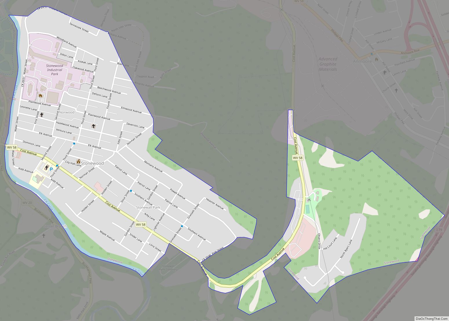
Stonewood is a city in Harrison County, West Virginia, United States. The population was 1,810 at the 2020 census. The name Stonewood has no special meaning, and was invented for the place. Stonewood city overview: Name: Stonewood city LSAD Code: 25 LSAD Description: city (suffix) State: West Virginia County: Harrison County Elevation: 1,037 ft (316 m) Total ... Read more
Map of Stonewood city
Map of Stollings CDP
Stollings is an unincorporated community and census-designated place (CDP) in central Logan County, West Virginia, United States. As of the 2010 census, it had a population of 316. Stollings CDP overview: Name: Stollings CDP LSAD Code: 57 LSAD Description: CDP (suffix) State: West Virginia County: Logan County Elevation: 673 ft (205 m) Total Area: 0.384 sq mi (0.99 km²) Land ... Read more
Map of Stollings CDP
Map of Star City town, West Virginia
Star City is a town in Monongalia County, West Virginia, United States. The population was 1,779 at the 2020 census. It is included in the Morgantown, West Virginia Metropolitan Statistical Area. Star City town overview: Name: Star City town LSAD Code: 43 LSAD Description: town (suffix) State: West Virginia County: Monongalia County Elevation: 955 ft (291 m) ... Read more
Map of Star City town, West Virginia
Map of Stanaford CDP
Stanaford is a census-designated place (CDP) and coal town in Raleigh County, West Virginia, United States. The population was 1,350 at the 2010 census. The community was named after nearby Stanaford Branch. Stanaford CDP overview: Name: Stanaford CDP LSAD Code: 57 LSAD Description: CDP (suffix) State: West Virginia County: Raleigh County Elevation: 2,402 ft (732 m) Total ... Read more
Map of Stanaford CDP
Map of St. Marys city, West Virginia
St. Marys is a city and the county seat of Pleasants County, West Virginia, United States. The population was 1,847 at the 2020 census. It is part of the Parkersburg–Vienna metropolitan area. St. Marys was established in 1849 by Alexander Creel, who is said to have had a vision of Mary while passing the townsite ... Read more
Map of St. Marys city, West Virginia
Map of St. George CDP, West Virginia
St. George CDP overview: Name: St. George CDP LSAD Code: 57 LSAD Description: CDP (suffix) State: West Virginia FIPS code: 5471284 Online Interactive Map St. George online map. Source: Basemap layers from Google Map, Open Street Map (OSM), Arcgisonline, Wmflabs. Boundary Data from Database of Global Administrative Areas. St. George location map. Where is St. ... Read more
Map of St. George CDP, West Virginia
Map of St. Albans city, West Virginia
St. Albans is a city in western Kanawha County, West Virginia, United States, at the confluence of the Kanawha and Coal rivers. The population was 10,861 at the 2020 census. It is part of the Charleston metropolitan area. St. Albans city overview: Name: St. Albans city LSAD Code: 25 LSAD Description: city (suffix) State: West ... Read more
Map of St. Albans city, West Virginia
Map of Springfield CDP, West Virginia
Springfield is a census-designated place (CDP) in northwestern Hampshire County in the U.S. state of West Virginia. As of the 2010 census, Springfield had a population of 477. Springfield is located north of Romney along West Virginia Route 28 at its junction with Green Spring Road (West Virginia Secondary Route 1) and Springfield Pike (West ... Read more
Map of Springfield CDP, West Virginia
Map of Wardensville town
Wardensville is a town in Hardy County, West Virginia, United States. The population was 265 at the 2020 census. Originally named Trout Run, Wardensville was chartered in Virginia in 1832 and incorporated in West Virginia in 1879. Wardensville is located west of the Great North Mountain range, which separates it from the Shenandoah Valley. The ... Read more
Map of Wardensville town
Map of Thurmond town
Thurmond is a town in Fayette County, West Virginia, United States, on the New River. The population was five at the 2020 census. During the heyday of coal mining in the New River Gorge, Thurmond was a prosperous town with a number of businesses and facilities for the Chesapeake and Ohio Railway. Most of Thurmond ... Read more
Map of Thurmond town
Map of War city
War is a city in McDowell County, West Virginia, United States. The population was 690 at the 2020 census. War was incorporated in 1920 by the Circuit Court of McDowell County. Its name is derived from War Creek, whose confluence with Dry Fork is located within the city. War is the only place in the ... Read more
Map of War city
Map of Thomas city, West Virginia
Thomas is a city and former coal town in Tucker County, West Virginia, United States. The population was 623 at the 2020 census. Thomas city overview: Name: Thomas city LSAD Code: 25 LSAD Description: city (suffix) State: West Virginia County: Tucker County Elevation: 3,035 ft (925 m) Total Area: 4.51 sq mi (11.67 km²) Land Area: 4.46 sq mi (11.55 km²) Water Area: ... Read more
Map of Thomas city, West Virginia