Map of Weston city, West Virginia
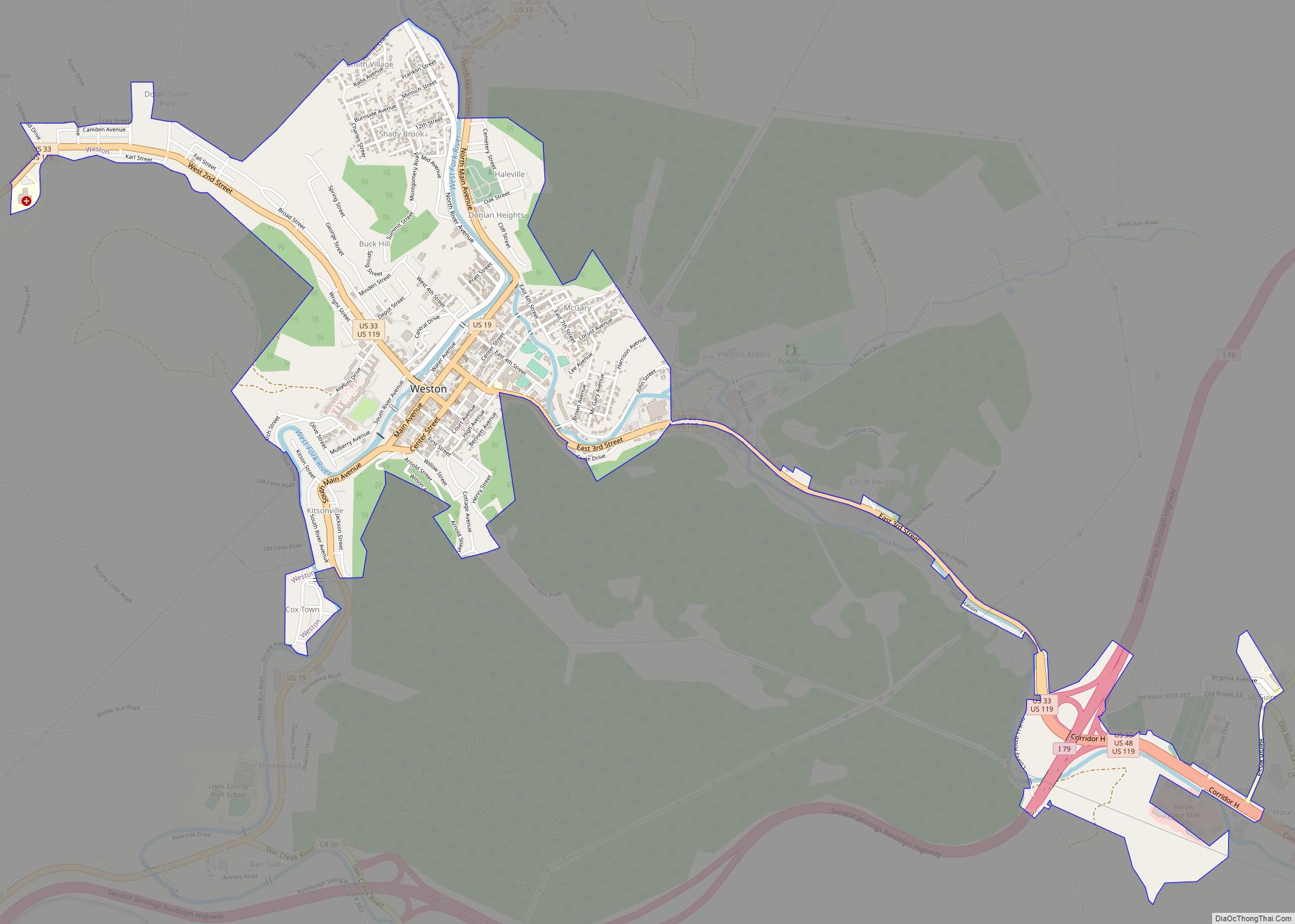
Weston is a city in Lewis County, West Virginia, United States. The population was 3,943 at the 2020 census. It is the county seat of Lewis County, and home to the Museum of American Glass in West Virginia and the Trans-Allegheny Lunatic Asylum. Weston city overview: Name: Weston city LSAD Code: 25 LSAD Description: city ... Read more
Map of Weston city, West Virginia
Map of West Union town, West Virginia
West Union, incorporated July 20, 1881, is a town in Doddridge County, West Virginia, United States. The population was 669 at the 2020 census. It is the county seat of Doddridge County. The town is located along Middle Island Creek at the junction of U.S. Route 50 and West Virginia Route 18; the North Bend ... Read more
Map of West Union town, West Virginia
Map of West Milford town
West Milford is a town in Harrison County, West Virginia, United States. The population was 452 at the 2020 census. West Milford was named on account of there being a mill on the ford of the West Fork River. West Milford town overview: Name: West Milford town LSAD Code: 43 LSAD Description: town (suffix) State: ... Read more
Map of West Milford town
Map of West Logan town
West Logan is a town along the Guyandotte River in Logan County, West Virginia, United States. The population was 400 at the 2020 census. For unknown reasons, some sources report West Logan to lay west of the county seat at Logan, attributing to this fact the name. West Logan town overview: Name: West Logan town ... Read more
Map of West Logan town
Map of West Liberty town, West Virginia
West Liberty is a town in Ohio County, West Virginia, United States. The population was 1,557 at the 2020 census. It is part of the Wheeling metropolitan area. West Liberty town overview: Name: West Liberty town LSAD Code: 43 LSAD Description: town (suffix) State: West Virginia County: Ohio County Elevation: 1,224 ft (373 m) Total Area: 1.09 sq mi ... Read more
Map of West Liberty town, West Virginia
Map of West Hamlin town
West Hamlin is a town in Lincoln County, West Virginia, United States, along the Guyandotte River. The population was 519 at the 2020 census, and is now down to 509, according to the 2021 census. West Hamlin is a part of the Huntington-Ashland, WV-KY-OH, Metropolitan Statistical Area (MSA). West Hamlin is west of the county ... Read more
Map of West Hamlin town
Map of Wellsburg city, West Virginia
Wellsburg is a city in and the county seat of Brooke County, West Virginia, United States. The 2020 census recorded a population of 2,455. It is a part of the Weirton–Steubenville metropolitan area. The city’s economy includes several telemarketing facilities, and a factory that does metal fabrication and plastics molding. Wellsburg city overview: Name: Wellsburg ... Read more
Map of Wellsburg city, West Virginia
Map of Albin town
Albin is a town in Laramie County, Wyoming, United States. It is part of the Cheyenne Metropolitan Statistical Area. The population was 181 at the 2010 census. Albin town overview: Name: Albin town LSAD Code: 43 LSAD Description: town (suffix) State: Wyoming County: Laramie County Elevation: 5,338 ft (1,627 m) Total Area: 0.15 sq mi (0.38 km²) Land Area: 0.15 sq mi ... Read more
Map of Albin town
Map of Afton town, Wyoming
Afton is a town in Lincoln County, Wyoming, United States. The population was 1,911 at the 2010 census. Afton is home to the world’s largest arch made of elk antlers. Spanning 75 feet (23 m) across the four lanes of U.S. Highway 89, the arch consists of 3,011 elk antlers and weighs 15 tons. Afton town ... Read more
Map of Afton town, Wyoming
Map of Auburn CDP, Wyoming
Auburn is a census-designated place (CDP) in Lincoln County, Wyoming, United States. As of the 2010 census, the CDP population was 328. The first settlement at Auburn was made in 1879. Auburn CDP overview: Name: Auburn CDP LSAD Code: 57 LSAD Description: CDP (suffix) State: Wyoming County: Lincoln County Elevation: 6,053 ft (1,845 m) Total Area: 2.1 sq mi ... Read more
Map of Auburn CDP, Wyoming
Map of Atlantic City CDP, Wyoming
Atlantic City is a census-designated place (CDP) in Fremont County, Wyoming, United States. The population was 37 at the 2010 census. The community is a small mining settlement in a gulch near South Pass in southwestern Wyoming. It was founded as a mining camp following the 1867 gold rush in the region. The town declined ... Read more
Map of Atlantic City CDP, Wyoming
Map of Arvada CDP, Wyoming
Arvada is a census-designated place in Sheridan County, Wyoming, United States. The population was 33 at the 2020 census. According to the United States Census Bureau, the CDP has a total area of 1.75 square miles (4.5 square kilometres), all land. Arvada CDP overview: Name: Arvada CDP LSAD Code: 57 LSAD Description: CDP (suffix) State: ... Read more
Map of Arvada CDP, Wyoming