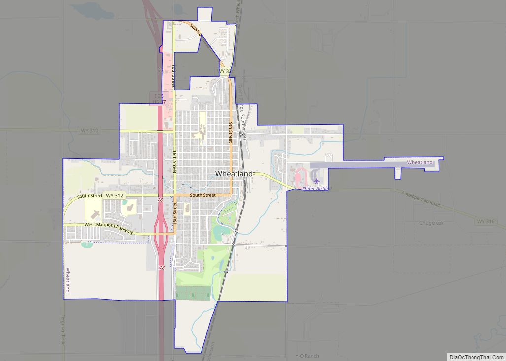
Map of Whiting CDP, Wyoming
Whiting is a census-designated place in Platte County, Wyoming, United States. The population was 83 at the 2010 census. Whiting CDP overview: Name: Whiting CDP LSAD Code: 57 LSAD Description: CDP (suffix) State: Wyoming County: Platte County FIPS code: 5683100 Online Interactive Map Whiting online map. Source: Basemap layers from Google Map, Open Street Map ... Read more
Map of Whiting CDP, Wyoming
Map of Y-O Ranch CDP
Y-O Ranch is a census-designated place (CDP) in Platte County, Wyoming, United States. The population was 195 at the 2010 census. Y-O Ranch CDP overview: Name: Y-O Ranch CDP LSAD Code: 57 LSAD Description: CDP (suffix) State: Wyoming County: Platte County Elevation: 4,885 ft (1,489 m) Total Area: 2.4 sq mi (6.3 km²) Land Area: 2.4 sq mi (6.3 km²) Water Area: 0.0 sq mi ... Read more
Map of Y-O Ranch CDP
Map of Hartsville/Trousdale County, Tennessee
Hartsville is a town in Trousdale County, Tennessee, United States. It is the county seat of Trousdale County, with which it shares a consolidated city-county government. The population of Hartsville was 11,615 as of 2020. Hartsville now shares with Trousdale County a consolidated city-county government by virtue of a referendum which passed in Trousdale County ... Read more
Map of Hartsville/Trousdale County, Tennessee
Map of Malaeloa/Aitulagi village, American Samoa
Malaeloa/Aitulagi village overview: Name: Malaeloa/Aitulagi village LSAD Code: 47 LSAD Description: village (suffix) State: American Samoa FIPS code: 6048920 Online Interactive Map Malaeloa/Aitulagi online map. Source: Basemap layers from Google Map, Open Street Map (OSM), Arcgisonline, Wmflabs. Boundary Data from Database of Global Administrative Areas. Malaeloa/Aitulagi location map. Where is Malaeloa/Aitulagi village? Malaeloa/Aitulagi Road Map ... Read more
Map of Malaeloa/Aitulagi village, American Samoa
Map of Louisville, Kentucky
Louisville city overview: Name: Louisville/Jefferson County metro government (balance) LSAD Code: 00 LSAD Description: metro government State: Kentucky County: Jefferson County Elevation: 466 ft (142 m) Land Area: 324.94 sq mi (841.59 km²) Water Area: 16.50 sq mi (42.73 km²) Population Density: 1,900/sq mi (720/km²) Area code: 502 FIPS code: 2148006 GNISfeature ID: 0509453 Website: louisvilleky.gov Louisville is a vibrant city located in northern ... Read more
Map of Louisville, Kentucky
Map of Krupp (Marlin) town, Washington
Krupp (Marlin) town overview: Name: Krupp (Marlin) town LSAD Code: 43 LSAD Description: town (suffix) State: Washington County: Grant County FIPS code: 5336395 Online Interactive Map Krupp (Marlin) online map. Source: Basemap layers from Google Map, Open Street Map (OSM), Arcgisonline, Wmflabs. Boundary Data from Database of Global Administrative Areas. Krupp (Marlin) location map. Where ... Read more
Map of Krupp (Marlin) town, Washington
Map of Yantis town
Yantis is a town in Wood County, Texas, United States. The population was 388 at the 2010 census. The town is surrounded on three sides by Lake Fork Reservoir. It is located at the intersection of State Highway 154 and Farm to Market Road 17 approximately 12 miles north of the county seat of Quitman ... Read more
Map of Yantis town
Map of Woodville town, Texas
Woodville is a town in Tyler County, Texas, United States. The town is intersected by three U.S. highways: U.S. Highway 69, U.S. Highway 190, and U.S. Highway 287. The population was 2,403 at the 2020 census. It is the county seat of Tyler County. The town was named after George Tyler Wood, governor of Texas ... Read more
Map of Woodville town, Texas
Map of Alpine city, Utah
Alpine is a city on the northeastern edge of Utah County, Utah, United States. The population was 10,251 at the time of the 2020 census. Alpine has been one of the many quickly-growing cities of Utah since the 1970s, especially in the 1990s. This city is thirty-two miles southeast of Salt Lake City. It is ... Read more
Map of Alpine city, Utah
Map of American Fork city
American Fork is a city in north-central Utah County, Utah, United States, at the foot of Mount Timpanogos in the Wasatch Range, north from Utah Lake. This city is thirty-two miles southeast of Salt Lake City. It is part of the Provo–Orem Metropolitan Statistical Area. The population was 33,337 in 2020. The city has grown ... Read more
Map of American Fork city
Map of Amalga town
Amalga (/əˈmælɡə/ ə-MAL-gə) is a town in Cache County, Utah, United States. The population was 488 at the 2010 census. It is included in the Logan, Utah–Idaho (partial) Metropolitan Statistical Area. Many of the town’s population are dairy farmers, with many families owning their own herds. The town contains the Cache Valley Cheese plant. Nearby ... Read more
Map of Amalga town
Map of Avon CDP, Utah
Avon is a census-designated place (CDP) in Cache County, Utah, United States. The population was 367 at the 2010 census. It is included in the Logan, Utah–Idaho (partial) Metropolitan Statistical Area. Avon is the birthplace of Reuben D. Law, first president of the Church College of Hawaii, later renamed Brigham Young University–Hawaii. Avon CDP overview: ... Read more
Map of Avon CDP, Utah