Map of Tanglewilde CDP
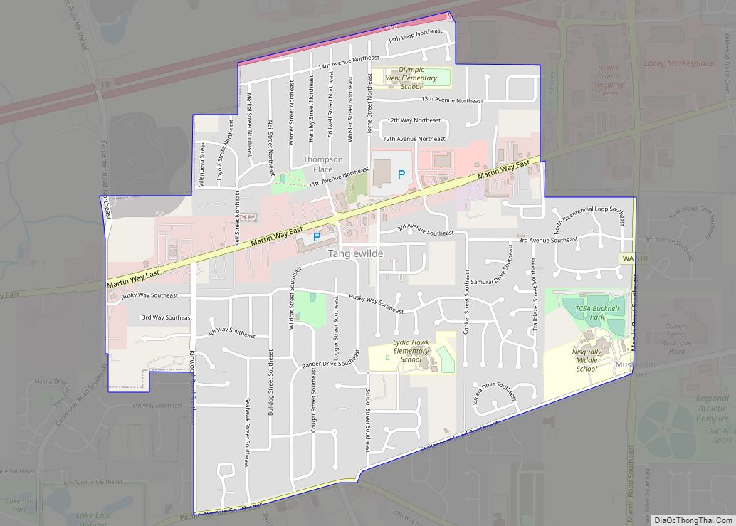
Tanglewilde (also Tanglewilde-Thompson Place) is a census-designated place (CDP) in Thurston County, Washington, United States, part of the Urban Growth Area of the city of Lacey. The community is surrounded by the city of Lacey and borders Mushroom Corner. The sections of Tanglewilde and Thompson Place are divided south and north, respectively, by Martin Way. ... Read more
Map of Tanglewilde CDP
Map of Waitsburg city
Waitsburg is a city in Walla Walla County, Washington, United States. The population was 1,166 at the 2020 census. Waitsburg has a unique city classification in Washington state, being the state’s only city which still operates under its territorial charter. Waitsburg city overview: Name: Waitsburg city LSAD Code: 25 LSAD Description: city (suffix) State: Washington ... Read more
Map of Waitsburg city
Map of Walla Walla East CDP
Walla Walla East is a census-designated place (CDP) in Walla Walla County, Washington, United States. The population was 1,672 at the 2010 census. Walla Walla East CDP overview: Name: Walla Walla East CDP LSAD Code: 57 LSAD Description: CDP (suffix) State: Washington County: Walla Walla County Total Area: 1.7 sq mi (4.4 km²) Land Area: 1.7 sq mi (4.4 km²) Water ... Read more
Map of Walla Walla East CDP
Map of Abrams CDP
Abrams is an unincorporated community census-designated place located in the town of Abrams, Oconto County, Wisconsin, United States. Abrams is located near U.S. Route 41 and U.S. Route 141 8 miles (13 km) south-southeast of Oconto Falls. Abrams has a post office with ZIP code 54101. As of the 2020 census, its population was 358. Abrams ... Read more
Map of Abrams CDP
Map of Abbotsford city
Abbotsford is a city in Clark (mostly) and Marathon counties in the U.S. state of Wisconsin. The population was 2,275 at the 2020 census. Of this, 1,665 were in Clark County, and 610 were in Marathon County. Abbotsford is nicknamed “Wisconsin’s First City” due to its alphabetical place on a list of Wisconsin cities. Abbotsford ... Read more
Map of Abbotsford city
Map of Almond village, Wisconsin
Almond is a town in Portage County, Wisconsin, United States. The population was 679 at the 2000 census. The unincorporated community of West Almond is located in the town. The Town of Almond was established in 1851. Almond village overview: Name: Almond village LSAD Code: 47 LSAD Description: village (suffix) State: Wisconsin County: Portage County ... Read more
Map of Almond village, Wisconsin
Map of Almena village, Wisconsin
The Town of Almena is in Barron County in the U.S. state of Wisconsin. The population was 858 at the 2010 census. The Village of Almena is partially located within the town. Almena village overview: Name: Almena village LSAD Code: 47 LSAD Description: village (suffix) State: Wisconsin County: Barron County FIPS code: 5501325 Online Interactive ... Read more
Map of Almena village, Wisconsin
Map of Alma city, Wisconsin
Alma is a city in and the county seat of Buffalo County, Wisconsin, United States. The population was 716 at the 2020 census. The motto for the city of Alma is: “Step into Living History.” Alma city overview: Name: Alma city LSAD Code: 25 LSAD Description: city (suffix) State: Wisconsin County: Buffalo County Elevation: 673 ft ... Read more
Map of Alma city, Wisconsin
Map of Allouez village
Allouez is a village in Brown County in the U.S. state of Wisconsin. The population was 13,975 at the 2010 census. It is part of the Green Bay Metropolitan Statistical Area. Allouez village overview: Name: Allouez village LSAD Code: 47 LSAD Description: village (suffix) State: Wisconsin County: Brown County Elevation: 597 ft (182 m) Total Area: 5.21 sq mi ... Read more
Map of Allouez village
Map of Arcadia city, Wisconsin
Arcadia is a city in Trempealeau County, Wisconsin, United States, along the Trempealeau River. The population was 3,737 at the 2020 census. Arcadia is a Latino-majority city and the largest city in Trempealeau county. Arcadia city overview: Name: Arcadia city LSAD Code: 25 LSAD Description: city (suffix) State: Wisconsin County: Trempealeau County Total Area: 3.27 sq mi ... Read more
Map of Arcadia city, Wisconsin
Map of Appleton city, Wisconsin
Appleton (Menominee: Ahkōnemeh) is a city in Outagamie, Calumet, and Winnebago counties in the U.S. state of Wisconsin. One of the Fox Cities, it is situated on the Fox River, 30 miles (48 km) southwest of Green Bay and 100 miles (160 km) north of Milwaukee. Appleton is the county seat of Outagamie County. As of the ... Read more
Map of Appleton city, Wisconsin
Map of Albany village, Wisconsin
Albany is a village in Green County, Wisconsin, United States. The population was 1,018 at the 2010 census. The village is located within the Town of Albany. Albany village overview: Name: Albany village LSAD Code: 47 LSAD Description: village (suffix) State: Wisconsin County: Green County Total Area: 1.29 sq mi (3.35 km²) Land Area: 1.27 sq mi (3.29 km²) Water Area: ... Read more
Map of Albany village, Wisconsin