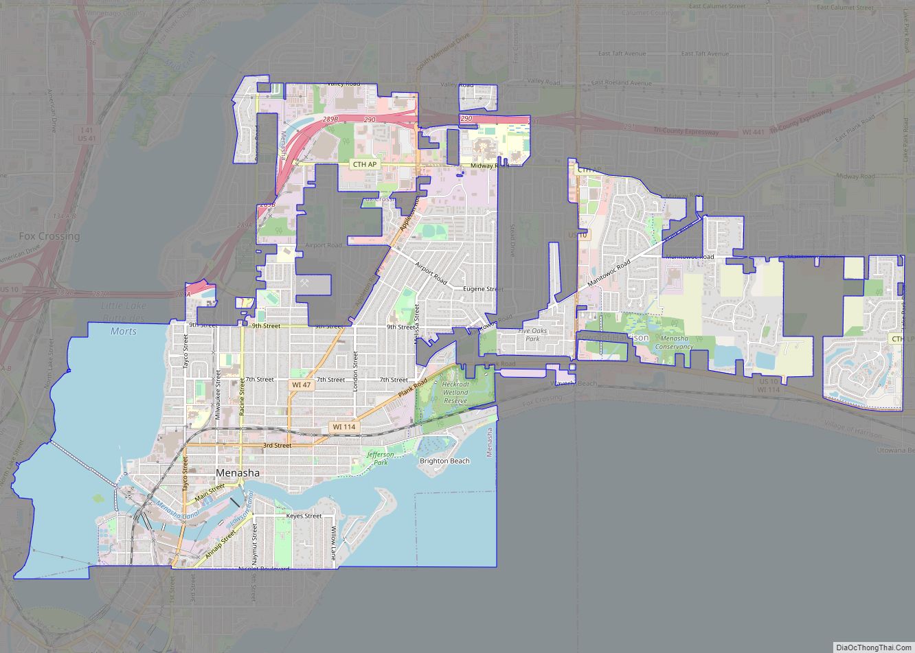
Map of Mole Lake CDP
Mole Lake, Wisconsin is a census-designated place located in the town of Nashville in Forest County, Wisconsin, United States. Mole Lake CDP overview: Name: Mole Lake CDP LSAD Code: 57 LSAD Description: CDP (suffix) State: Wisconsin County: Forest County Elevation: 1,552 ft (473 m) Total Area: 4.160 sq mi (10.77 km²) Land Area: 3.698 sq mi (9.58 km²) Water Area: 0.462 sq mi (1.20 km²) Total ... Read more
Map of Mole Lake CDP
Map of Milladore village
Milladore is a village in Wood County and overlapping into Portage County in the U.S. state of Wisconsin. The population was 276 at the 2010 census. Most of the village is located within the Town of Milladore in Wood County, while only a very small portion of the village lies in Portage County. All of ... Read more
Map of Milladore village
Map of Montello city, Wisconsin
Montello is a city in and the county seat of Marquette County, Wisconsin, United States. The population was 1,495 at the 2010 census. The Fox River flows through the city. Montello is home to the largest tree in Wisconsin. A notable attraction in the city is the former granite quarry, which has been transformed into ... Read more
Map of Montello city, Wisconsin
Map of Monroe city, Wisconsin
Monroe is a town in Green County, Wisconsin, United States. The population was 10,142 at the 2000 census. The City of Monroe is located partially within the town. The unincorporated community of Stearns is also located in the town. Monroe city overview: Name: Monroe city LSAD Code: 25 LSAD Description: city (suffix) State: Wisconsin County: ... Read more
Map of Monroe city, Wisconsin
Map of New Auburn village, Wisconsin
New Auburn is a village in Barron and Chippewa counties in the U.S. state of Wisconsin. The population was 548 at the 2010 census. Of this, 528 were in Chippewa County, and 20 were in Barron County. The village is located mostly within the Town of Auburn in Chippewa County. Small portions extend east into ... Read more
Map of New Auburn village, Wisconsin
Map of Mount Sterling village, Wisconsin
Mount Sterling is a village in Crawford County, Wisconsin, United States. The population was 211 at the 2010 census. Mount Sterling village overview: Name: Mount Sterling village LSAD Code: 47 LSAD Description: village (suffix) State: Wisconsin County: Crawford County Elevation: 1,184 ft (361 m) Total Area: 1.42 sq mi (3.68 km²) Land Area: 1.42 sq mi (3.68 km²) Water Area: 0.00 sq mi (0.00 km²) Total ... Read more
Map of Mount Sterling village, Wisconsin
Map of Mount Pleasant village, Wisconsin
Mount Pleasant is a village in Racine County, Wisconsin, United States. It is located approximately 30 miles (48 kilometers) south of Milwaukee and 60 mi (97 km) north of Chicago. As of the 2020 census, the village’s population was 27,732. Mount Pleasant village overview: Name: Mount Pleasant village LSAD Code: 47 LSAD Description: village (suffix) State: Wisconsin ... Read more
Map of Mount Pleasant village, Wisconsin
Map of Nelsonville village, Wisconsin
Nelsonville is a village in Portage County, Wisconsin, United States. The population was 155 at the 2010 census. Nelsonville village overview: Name: Nelsonville village LSAD Code: 47 LSAD Description: village (suffix) State: Wisconsin County: Portage County Elevation: 1,073 ft (327 m) Total Area: 1.05 sq mi (2.71 km²) Land Area: 1.03 sq mi (2.67 km²) Water Area: 0.01 sq mi (0.04 km²) Total Population: 155 Population ... Read more
Map of Nelsonville village, Wisconsin
Map of Nelson village, Wisconsin
Nelson is a town in Buffalo County in the U.S. state of Wisconsin. The population was 571 at the 2010 census. The village of Nelson is located within the town. The unincorporated communities of Misha Mokwa and Trevino are located in the town. The unincorporated community of Urne is located partially in the town. Nelson ... Read more
Map of Nelson village, Wisconsin
Map of Nekoosa city
Nekoosa is a city in Wood County, Wisconsin, United States. Its name derives from the Ho-Chunk word, “Nįįkuusra”, “Nakrusa”, or “Nįkusara” which translates to “running water”. The population was 2,580 at the 2010 census. Nekoosa city overview: Name: Nekoosa city LSAD Code: 25 LSAD Description: city (suffix) State: Wisconsin County: Wood County Elevation: 951 ft (290 m) ... Read more
Map of Nekoosa city
Map of Neenah city
Neenah (/ˈniːnə/) is a city in Winnebago County, Wisconsin, in the north central United States. It is situated on the banks of Lake Winnebago, Little Lake Butte des Morts, and the Fox River, approximately forty miles (64 km) southwest of Green Bay. Neenah’s population was 27,319 at the 2020 census. Neenah is bordered by the Town ... Read more
Map of Neenah city
Map of North Freedom village
North Freedom is a village along the Baraboo River in Sauk County, Wisconsin, United States. The population was 701 at the 2010 census. North Freedom village overview: Name: North Freedom village LSAD Code: 47 LSAD Description: village (suffix) State: Wisconsin County: Sauk County Elevation: 879 ft (268 m) Total Area: 0.89 sq mi (2.31 km²) Land Area: 0.84 sq mi (2.17 km²) Water ... Read more
Map of North Freedom village