Map of Collbran town
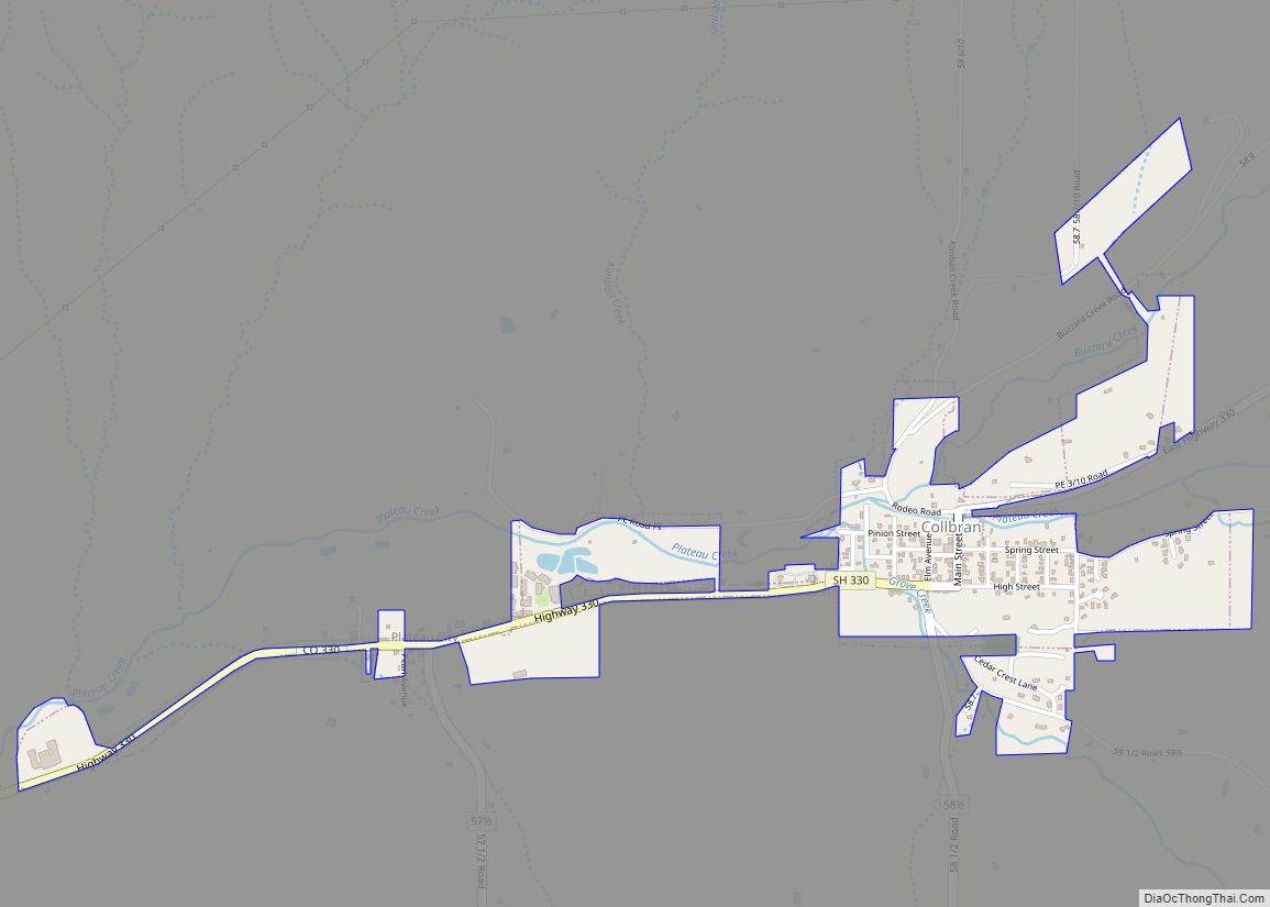
The Town of Collbran is a Statutory Town located in Mesa County, Colorado, United States. The town population was 369 at the 2020 United States Census. Collbran is a part of the Grand Junction, CO Metropolitan Statistical Area. Collbran town overview: Name: Collbran town LSAD Code: 43 LSAD Description: town (suffix) State: Colorado County: Mesa ... Read more
Map of Collbran town
Map of Cokedale town
The Town of Cokedale is a Statutory Town located in Las Animas County, Colorado, United States. The town population was 127 at the 2020 United States Census. Cokedale town overview: Name: Cokedale town LSAD Code: 43 LSAD Description: town (suffix) State: Colorado County: Las Animas County Incorporated: March 15, 1948 Elevation: 6,332 ft (1,930 m) Total Area: ... Read more
Map of Cokedale town
Map of Columbine CDP
Columbine is census-designated place (CDP) in and governed by Jefferson and Arapahoe counties in Colorado, United States. The CDP is a part of the Denver metropolitan area. Located primarily in Jefferson County, Columbine lies immediately south of Denver. The population of the Columbine CDP was 25,229 at the 2020 census. The community lies in ZIP ... Read more
Map of Columbine CDP
Map of Columbine Valley town
The Town of Columbine Valley is a Statutory Town located in western Arapahoe County, Colorado, United States. The town population was 1,502 at the 2020 United States Census, a +19.59% increase since the 2010 United States Census. Columbine Valley is a part of the Denver-Aurora-Lakewood, CO Metropolitan Statistical Area and the Front Range Urban Corridor. ... Read more
Map of Columbine Valley town
Map of Colorado City CDP, Colorado
Colorado City is a census-designated place (CDP) and post office in and governed by Pueblo County, Colorado, United States. The CDP is a part of the Pueblo, CO Metropolitan Statistical Area. The Colorado City post office has the ZIP Code 81019 (post office boxes). At the United States Census 2020, the population of the Colorado ... Read more
Map of Colorado City CDP, Colorado
Map of Conejos CDP
Conejos is an unincorporated town, a post office, a census-designated place (CDP), and the county seat of Conejos County, Colorado, United States. The Conejos post office has the ZIP Code 81129. At the United States Census 2020, the population of the Conejos CDP was 46. Conejos is the only unincorporated county seat in the State ... Read more
Map of Conejos CDP
Map of Commerce City
The City of Commerce City is a home rule municipality located in Adams County, Colorado, United States. The city population was 62,418 at the 2020 United States Census, a 35.95% increase since the 2010 United States Census. Commerce City is the 18th most populous municipality in Colorado. Commerce City is located north of Denver and ... Read more
Map of Commerce City
Map of Comanche Creek CDP
Comanche Creek is an unincorporated community and a census-designated place (CDP) located in and governed by Arapahoe County, Colorado, United States. The CDP is a part of the Denver–Aurora–Lakewood, CO Metropolitan Statistical Area. The population of the Comanche Creek CDP was 442 at the United States Census 2020. The Strasburg post office (Zip code 80136) ... Read more
Map of Comanche Creek CDP
Map of Cotopaxi CDP
Cotopaxi is an unincorporated town, a post office, and a census-designated place (CDP) located in and governed by Fremont County, Colorado, United States. The CDP is a part of the Cañon City, CO Micropolitan Statistical Area. The Cotopaxi post office has the ZIP Code 81223. At the United States Census 2020, the population of the ... Read more
Map of Cotopaxi CDP
Map of Cortez city, Colorado
Cortez (/ˈkɔːrtɛz/ (listen)) is a home rule municipality that is the county seat and the most populous municipality of Montezuma County, Colorado, United States. The city population was 8,766 at the 2020 United States Census. Cortez city overview: Name: Cortez city LSAD Code: 25 LSAD Description: city (suffix) State: Colorado County: Montezuma County Elevation: 6,191 ft ... Read more
Map of Cortez city, Colorado
Map of Copper Mountain CDP
Copper Mountain is an unincorporated community and a census-designated place (CDP) located in and governed by Summit County, Colorado, United States. The CDP is a part of the Breckenridge, CO Micropolitan Statistical Area. The population of the Copper Mountain CDP was 650 at the United States Census 2020. The Copper Mountain Consolidated Metropolitan District provides ... Read more
Map of Copper Mountain CDP
Map of Crested Butte town
Crested Butte is a home rule municipality located in Gunnison County, Colorado, United States. The town population was 1,639 at the 2020 United States Census. The former coal mining town is now called “the last great Colorado ski town”. Crested Butte is a destination for skiing, mountain biking, and outdoor activities. The Colorado General Assembly ... Read more
Map of Crested Butte town