Map of Fleming town, Colorado
The Town of Fleming is a Statutory Town in Logan County, Colorado, United States. The town population was 428 at the 2020 United States Census. Fleming is a part of the Sterling, CO Micropolitan Statistical Area. Fleming town overview: Name: Fleming town LSAD Code: 43 LSAD Description: town (suffix) State: Colorado County: Logan County Elevation: ... Read more
Map of Fleming town, Colorado
Map of Flagler town
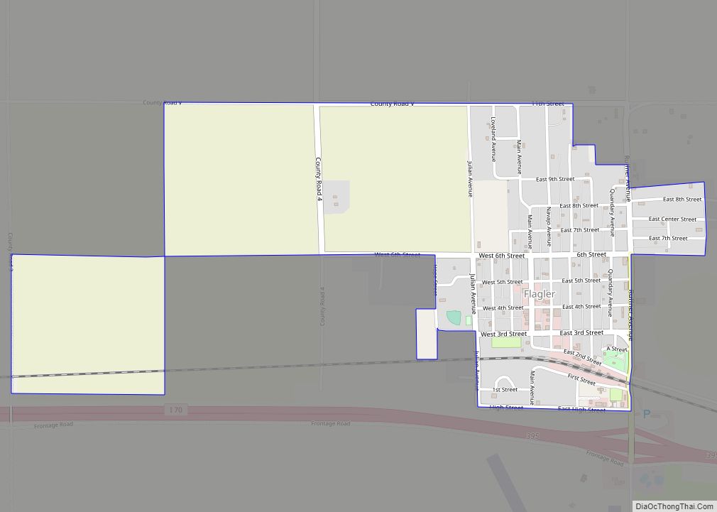
The Town of Flagler is a Statutory Town in western Kit Carson County, Colorado, United States. The town population was 567 at the 2020 United States Census. Flagler is near Exit 395 on I-70 and about 120 miles east of Denver and Colorado Springs. Flagler town overview: Name: Flagler town LSAD Code: 43 LSAD Description: ... Read more
Map of Flagler town
Map of Fort Carson CDP
Fort Carson is a United States Army post located directly south of Colorado Springs in El Paso, Pueblo, Fremont, and Huerfano counties, Colorado, United States. The developed portion of Fort Carson is located near the City of Colorado Springs in El Paso County. Fort Carson is the home of the 4th Infantry Division, the 10th ... Read more
Map of Fort Carson CDP
Map of Floyd Hill CDP
Floyd Hill is an unincorporated community and a census-designated place (CDP) located in and governed by Clear Creek County, Colorado, United States. The CDP is a part of the Denver–Aurora–Lakewood, CO Metropolitan Statistical Area. The population of the Floyd Hill CDP was 1,048 at the United States Census 2020. The Evergreen post office (Zip Code ... Read more
Map of Floyd Hill CDP
Map of Florissant CDP, Colorado
Florissant is an unincorporated town, a post office, and a census-designated place (CDP) located in and governed by Teller County, Colorado, United States. The CDP is a part of the Colorado Springs, CO Metropolitan Statistical Area. The Florissant post office has the ZIP Code 80816. At the United States Census 2020, the population of the ... Read more
Map of Florissant CDP, Colorado
Map of Fort Morgan city
Fort Morgan is the home rule municipality city that is the county seat and the most populous municipality of Morgan County, Colorado, United States. The city population was 11,597 at the 2020 United States Census. Fort Morgan is the principal city of the Fort Morgan, CO Micropolitan Statistical Area. Fort Morgan city overview: Name: Fort ... Read more
Map of Fort Morgan city
Map of Fort Lupton city
The City of Fort Lupton is a Statutory City located in southern Weld County, Colorado, United States. The town population was 7,955 at the 2020 United States Census. Fort Lupton is a part of the Greeley, Colorado Metropolitan Statistical Area and the Front Range Urban Corridor. Fort Lupton city overview: Name: Fort Lupton city LSAD ... Read more
Map of Fort Lupton city
Map of Fort Garland CDP
Fort Garland is an unincorporated town, a post office, and a census-designated place (CDP) located in and governed by Costilla County, Colorado, United States. The Fort Garland post office has the ZIP Code 81133. At the United States Census 2020, the population of the Fort Garland CDP was 464. Fort Garland CDP overview: Name: Fort ... Read more
Map of Fort Garland CDP
Map of Foxfield town
The Town of Foxfield is a statutory town located in Arapahoe County, Colorado, United States. The town population was 754 at the 2020 United States Census. Foxfield is a part of the Denver–Aurora–Lakewood, CO Metropolitan Statistical Area and the Front Range Urban Corridor. The town is bordered by the cities of Aurora and Centennial. Foxfield ... Read more
Map of Foxfield town
Map of Fowler town, Colorado
The Town of Fowler is a statutory town located in northwestern Otero County, Colorado, United States. The town population was 1,253 at the 2020 United States Census. Fowler town overview: Name: Fowler town LSAD Code: 43 LSAD Description: town (suffix) State: Colorado County: Otero County Elevation: 4,340 ft (1,322 m) Total Area: 0.563 sq mi (1.458 km²) Land Area: 0.000 sq mi ... Read more
Map of Fowler town, Colorado
Map of Fountain city, Colorado
The City of Fountain is a home rule municipality located in El Paso County, Colorado, United States. The city population was 29,802 at the 2020 United States Census, a +15.31% increase since the 2010 United States Census. Fountain is a part of the Colorado Springs, CO Metropolitan Statistical Area and the Front Range Urban Corridor. ... Read more
Map of Fountain city, Colorado
Map of Franktown CDP
Franktown is an unincorporated town, a post office, and a census-designated place (CDP) located in and governed by Douglas County, Colorado, United States. The CDP is a part of the Denver–Aurora–Lakewood, CO Metropolitan Statistical Area. The Franktown post office has the ZIP Code 80116. At the United States Census 2020, the population of the Franktown ... Read more
Map of Franktown CDP