Map of Ellenton CDP, Florida
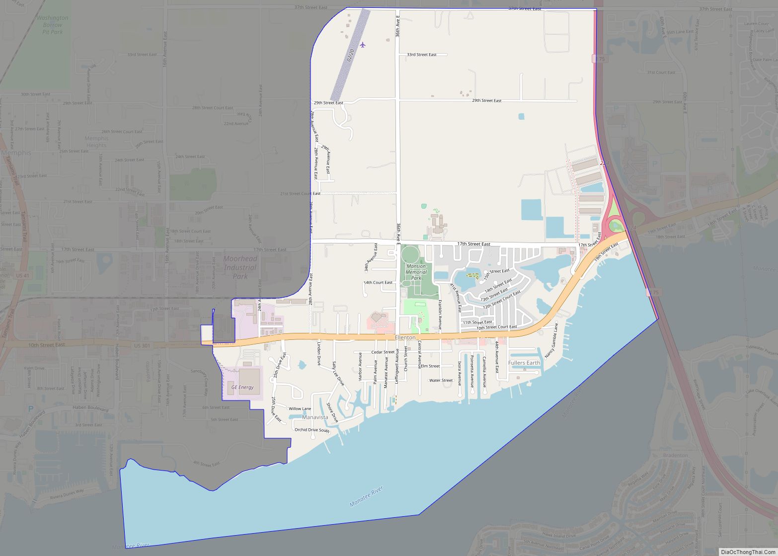
Ellenton is an unincorporated community and census-designated place (CDP) in Manatee County, Florida, United States. The population was 4,129 at the 2020 census. It is part of the Bradenton-Sarasota-Venice, Florida Metropolitan Statistical Area. Ellenton CDP overview: Name: Ellenton CDP LSAD Code: 57 LSAD Description: CDP (suffix) State: Florida County: Manatee County Elevation: 10 ft (3 m) Total ... Read more
Map of Ellenton CDP, Florida
Map of Elfers CDP
Elfers is a census-designated place (CDP) in Pasco County, Florida, United States. The population was 13,161 at the 2000 census. Elfers CDP overview: Name: Elfers CDP LSAD Code: 57 LSAD Description: CDP (suffix) State: Florida County: Pasco County Elevation: 39 ft (12 m) Total Area: 3.75 sq mi (9.72 km²) Land Area: 3.73 sq mi (9.65 km²) Water Area: 0.03 sq mi (0.06 km²) Total Population: ... Read more
Map of Elfers CDP
Map of Esto town
Esto is a town in Holmes County, Florida, United States. The population was 364 at the 2010 census. Esto town overview: Name: Esto town LSAD Code: 43 LSAD Description: town (suffix) State: Florida County: Holmes County Elevation: 233 ft (71 m) Total Area: 2.36 sq mi (6.13 km²) Land Area: 2.18 sq mi (5.64 km²) Water Area: 0.19 sq mi (0.48 km²) Total Population: 341 Population ... Read more
Map of Esto town
Map of Estero village
Estero is a village in Lee County, Florida, United States. As of the 2020 census, the population was 36,939. During the 2010 census, Estero was an unincorporated community, or census-designated place, the population at that time was 22,612. Estero incorporated as a village in 2014. In 2019, the village’s estimated population was 33,871. Estero is ... Read more
Map of Estero village
Map of Ensley CDP
Ensley is a census-designated place (CDP) in Escambia County, Florida. It is a community in Pensacola, and is located northwest of Pensacola City Limits. As of the 2010 United States Census, the population was 20,602. It is part of the Pensacola–Ferry Pass–Brent Metropolitan Statistical Area. Ensley is a transportation corridor for the Pensacola Area, with ... Read more
Map of Ensley CDP
Map of Fairview Shores CDP
Fairview Shores is a census-designated place and an unincorporated area in Orange County, Florida, United States. The population was 10,239 at the 2010 census. It is part of the Orlando–Kissimmee–Sanford, Florida Metropolitan Statistical Area. Fairview Shores CDP overview: Name: Fairview Shores CDP LSAD Code: 57 LSAD Description: CDP (suffix) State: Florida County: Orange County Elevation: ... Read more
Map of Fairview Shores CDP
Map of Everglades city
Everglades city overview: Name: Everglades city LSAD Code: 25 LSAD Description: city (suffix) State: Florida County: Collier County FIPS code: 1221425 Online Interactive Map Everglades online map. Source: Basemap layers from Google Map, Open Street Map (OSM), Arcgisonline, Wmflabs. Boundary Data from Database of Global Administrative Areas. Everglades location map. Where is Everglades city? Everglades ... Read more
Map of Everglades city
Map of Eustis city, Florida
Eustis is a city in Lake County, Florida, United States. The population was 23,189 at the 2020 census. It is part of the Orlando–Kissimmee–Sanford Metropolitan Statistical Area. Eustis High School is the town’s local public high school. The City of Eustis holds a festival every year which begins on the last Friday of February and ... Read more
Map of Eustis city, Florida
Map of Fellsmere city
Fellsmere is a city in Indian River County, Florida, United States. It is home of the Fellsmere Frog Leg Festival and the now closed National Elephant Center. Fellsmere is the first place in Florida where women were allowed to vote. In a municipal election on June 19, 1915, resident Zena M. Dreier became the first ... Read more
Map of Fellsmere city
Map of Feather Sound CDP
Feather Sound is a census-designated place (CDP) in Pinellas County, Florida, United States. The population was 3,420 at the 2010 census. It includes the St. Petersburg-Clearwater International Airport. Feather Sound CDP overview: Name: Feather Sound CDP LSAD Code: 57 LSAD Description: CDP (suffix) State: Florida County: Pinellas County Elevation: 6 ft (2 m) Total Area: 3.43 sq mi (8.88 km²) ... Read more
Map of Feather Sound CDP
Map of Fanning Springs city
Fanning Springs is a city in Gilchrist and Levy counties in the U.S. state of Florida. The population was 764 at the 2010 census. Fanning Springs city overview: Name: Fanning Springs city LSAD Code: 25 LSAD Description: city (suffix) State: Florida County: Gilchrist County, Levy County Elevation: 30 ft (9 m) Total Area: 5.00 sq mi (12.96 km²) Land Area: ... Read more
Map of Fanning Springs city
Map of Fernandina Beach city
Fernandina Beach is a city in northeastern Florida and the county seat of Nassau County, Florida, United States. It is the northernmost city on Florida’s Atlantic coast, situated on Amelia Island, and is one of the principal municipalities comprising Greater Jacksonville. The area was first inhabited by the Timucuan Indian people. Known as the “Isle ... Read more
Map of Fernandina Beach city