Map of Glenvar Heights CDP
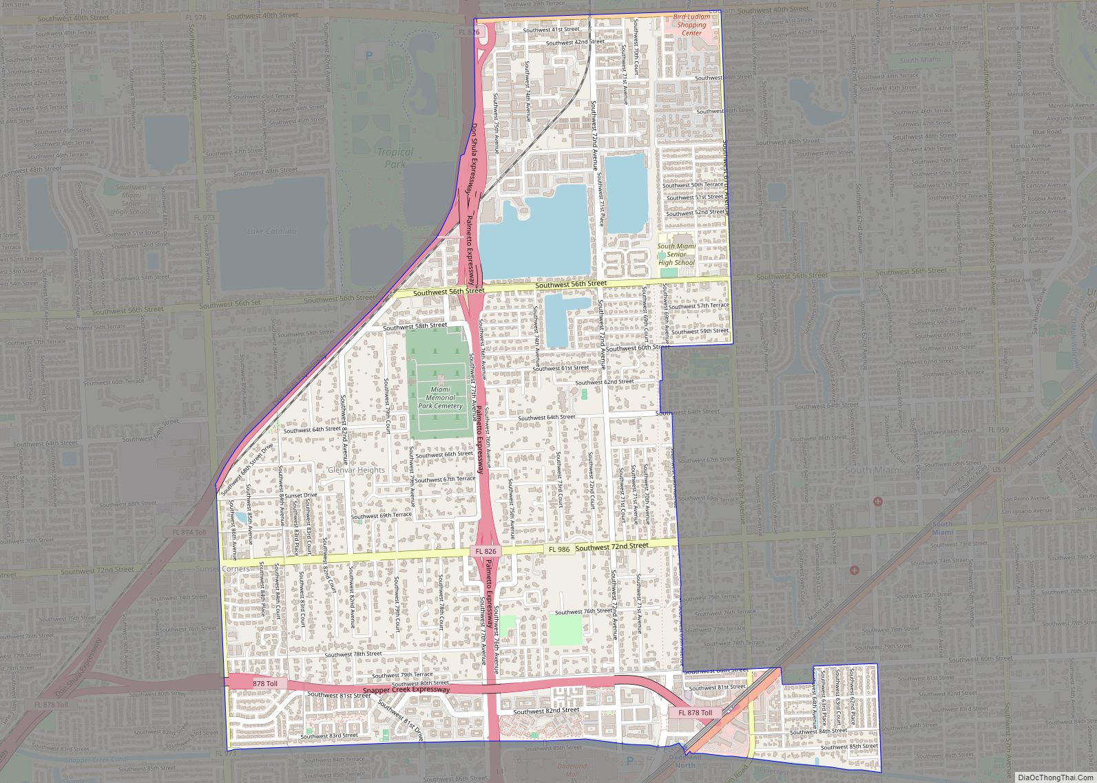
Glenvar Heights is a census-designated place (CDP) and neighborhood in Miami-Dade County, Florida, United States. The population was 20,786 at the 2020 census, up from 16,898 in 2010. The community is served by the Miami ZIP codes 33143 and 33155. Glenvar Heights CDP overview: Name: Glenvar Heights CDP LSAD Code: 57 LSAD Description: CDP (suffix) ... Read more
Map of Glenvar Heights CDP
Map of Glencoe CDP, Florida
Glencoe is a census-designated place (CDP) in Volusia County, Florida, United States. The population was 2,582 at the 2010 census. Glencoe CDP overview: Name: Glencoe CDP LSAD Code: 57 LSAD Description: CDP (suffix) State: Florida County: Volusia County Elevation: 20 ft (6 m) Total Area: 3.47 sq mi (8.99 km²) Land Area: 3.47 sq mi (8.99 km²) Water Area: 0.00 sq mi (0.00 km²) Total Population: ... Read more
Map of Glencoe CDP, Florida
Map of Goldenrod CDP
Goldenrod is a census-designated place (CDP) in Orange and Seminole counties in the U.S. state of Florida. The population was 12,039 at the 2010 census. It is part of the Orlando–Kissimmee–Sanford, Florida Metropolitan Statistical Area. Goldenrod CDP overview: Name: Goldenrod CDP LSAD Code: 57 LSAD Description: CDP (suffix) State: Florida County: Orange County, Seminole County ... Read more
Map of Goldenrod CDP
Map of Golden Glades CDP
Golden Glades is a census-designated place (CDP) in Miami-Dade County, Florida, United States. The population was 32,499 at the 2020 census. It is the location for a Golden Glades Interchange which connects the Florida Turnpike, Interstate 95, US 441, State Road 9, and the Palmetto Expressway. Golden Glades CDP overview: Name: Golden Glades CDP LSAD ... Read more
Map of Golden Glades CDP
Map of Golden Gate CDP, Florida
Golden Gate is a community and census-designated place (CDP) in Collier County, Florida, United States. Golden Gate’s boundaries coincide with a 2 by 2 miles (3.2 by 3.2 km) square of significantly higher density development than surrounding areas. The population was 23,961 as recorded in the 2010 census. It is part of the Naples–Marco Island Metropolitan ... Read more
Map of Golden Gate CDP, Florida
Map of Goodland CDP, Florida
Goodland is a census-designated place (CDP) in Collier County, Florida, United States. The population was 267 at the 2010 census. It is part of the Naples–Marco Island Metropolitan Statistical Area. Located on the southeast portion of Marco Island, it is the closest community to Cape Romano, the southern tip of a nearby island that was ... Read more
Map of Goodland CDP, Florida
Map of Gonzalez CDP
Gonzalez is a census-designated place (CDP) in Escambia County, Florida. Gonzalez is located north of Pensacola, and is considered to be within Cantonment. Tate High School, the largest public school in Escambia County, is located in the Gonzalez area. As of the 2020 United States Census, the population was 14,586. Gonzalez CDP overview: Name: Gonzalez ... Read more
Map of Gonzalez CDP
Map of Golf village, Florida
The Village of Golf is a village in Palm Beach County, Florida, United States. As of 2018, the population recorded by the U.S. Census Bureau was 275. Golf village overview: Name: Golf village LSAD Code: 47 LSAD Description: village (suffix) State: Florida County: Palm Beach County Elevation: 13 ft (4 m) Total Area: 0.83 sq mi (2.15 km²) Land Area: ... Read more
Map of Golf village, Florida
Map of Goulding CDP
Goulding is a census-designated place (CDP) in Escambia County, Florida. It is considered to be a community within Pensacola. The population was 4,102 at the 2010 census. It is part of the Pensacola–Ferry Pass–Brent Metropolitan Statistical Area. Goulding CDP overview: Name: Goulding CDP LSAD Code: 57 LSAD Description: CDP (suffix) State: Florida County: Escambia County ... Read more
Map of Goulding CDP
Map of Gotha CDP
Gotha is a census-designated place (CDP) in Orange County, Florida, United States. Gotha is located between Ocoee and Windermere and had a population of 1,915 at the 2010 census, up from 731 as recorded by the 2000 census. It is part of the Orlando–Kissimmee Metropolitan Statistical Area. It is the resting place of the famous ... Read more
Map of Gotha CDP
Map of Goulds CDP
Goulds is an unincorporated community and census-designated place (CDP) in Miami-Dade County, Florida, United States. The area was originally populated as the result of a stop on the Florida East Coast Railroad. The railroad depot was located near the current Southwest 224th Street. The community was named after its operator, Lyman Gould, who cut trees ... Read more
Map of Goulds CDP
Map of Grant-Valkaria town
Grant-Valkaria is a town in Brevard County, Florida. The town’s population was 4,449 at 2022. Grant-Valkaria is located south of Melbourne, between Palm Bay and Sebastian. It is part of the Palm Bay–Melbourne–Titusville Metropolitan Statistical Area. Grant-Valkaria was incorporated as a town on July 25, 2006, by joining the two previously unincorporated communities of Grant ... Read more
Map of Grant-Valkaria town