Map of Boaz city

Map of Boaz city, Alabama

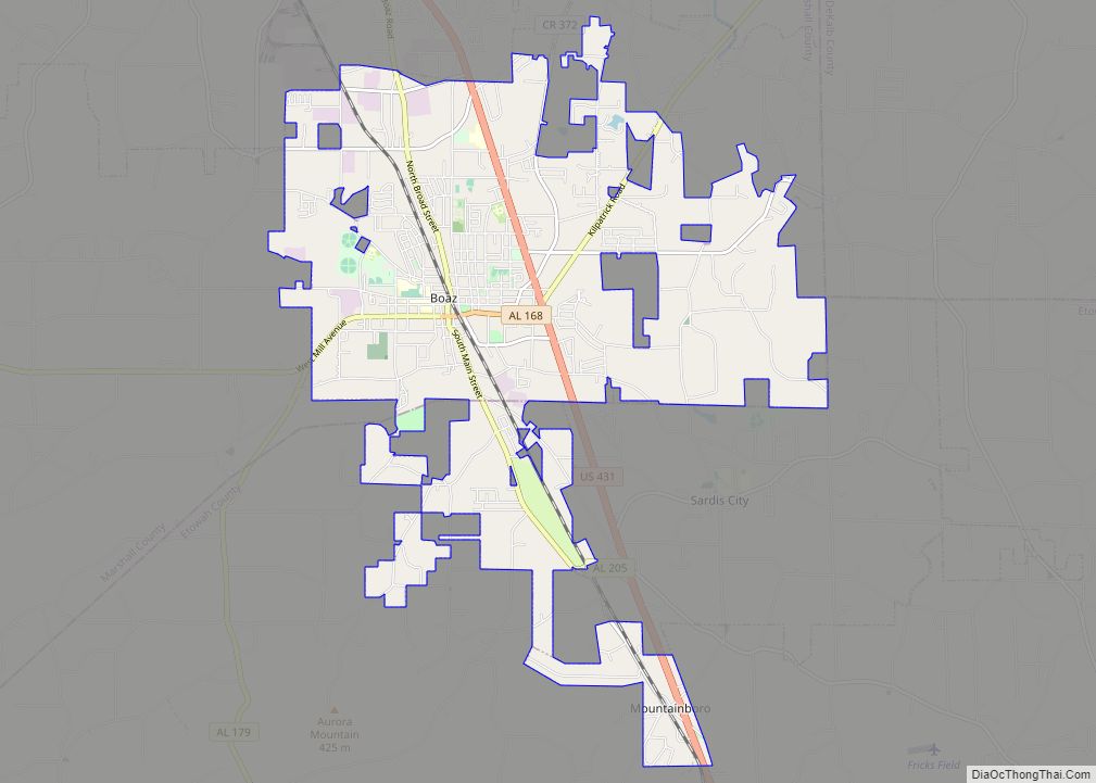
Boaz is a city in Marshall and Etowah counties in the U.S. state of Alabama. The Marshall County portion of the city is part of the Albertville Micropolitan Statistical Area. As of the 2020 census, the city’s population was 10,107. Boaz was known for its outlet shops. Boaz city overview: Name: Boaz city LSAD Code: … Read more

Map of Blue Springs town

Map of Blue Springs town, Alabama

Blue Springs is a town in Barbour County, Alabama, United States. At the 2020 census, the population was 84. The town is the home of Blue Springs State Park. Blue Springs town overview: Name: Blue Springs town LSAD Code: 43 LSAD Description: town (suffix) State: Alabama County: Barbour County Elevation: 305 ft (93 m) Total Area: 2.90 sq mi … Read more

Map of Boykin CDP

Map of Boykin CDP, Alabama

Boykin, also known as Gee’s Bend, is an African American majority community and census-designated place in a large bend of the Alabama River in Wilcox County, Alabama. As of the 2020 census, its population was 208. The Boykin Post Office was established in the community in 1949 and remains active, servicing the 36723 ZIP code. … Read more

Map of Bon Secour CDP

Map of Bon Secour CDP

Bon Secour /bɑːn səˈkjuːr/ is an unincorporated community and census-designated place in Baldwin County, Alabama, United States. It lies along the eastern coastline of Bon Secour Bay (a contiguous bay that sits along the eastern edge of Mobile Bay). Bon Secour is over 35 miles (56 km) due east of the Alabama–Mississippi state line, near Gulf … Read more

Map of Bon Air town

Map of Bon Air town, Alabama

Bon Air is a town in Talladega County, Alabama, United States. It incorporated in 1932. At the 2010 census the population was 116, up from 96 in 2000. Bon Air town overview: Name: Bon Air town LSAD Code: 43 LSAD Description: town (suffix) State: Alabama County: Talladega County Elevation: 440 ft (134 m) Total Area: 1.33 sq mi (3.45 km²) … Read more

Map of Brent city

Map of Brent city, Alabama

Brent is a city in Bibb County, Alabama, United States. At the 2020 census, the population was 2,972. Brent city overview: Name: Brent city LSAD Code: 25 LSAD Description: city (suffix) State: Alabama County: Bibb County Elevation: 240 ft (70 m) Total Area: 8.83 sq mi (22.87 km²) Land Area: 8.80 sq mi (22.79 km²) Water Area: 0.03 sq mi (0.08 km²) Total Population: 2,972 Population … Read more

Map of Brantleyville CDP

Map of Brantleyville CDP

Brantleyville is a census-designated place and Unincorporated community in Shelby County, Alabama, United States. Its population was 884 as of the 2010 census. Brantleyville CDP overview: Name: Brantleyville CDP LSAD Code: 57 LSAD Description: CDP (suffix) State: Alabama County: Shelby County Elevation: 554 ft (169 m) Total Area: 2.21 sq mi (5.71 km²) Land Area: 2.20 sq mi (5.69 km²) Water Area: 0.01 sq mi … Read more

Map of Brantley town

Map of Brantley town

Brantley is a city in Crenshaw County, Alabama, United States. Brantley is also commonly known as a speed trap town by the locals of Alabama. At the 2020 census, the population was 825. Brantley was incorporated in 1891 as a city. Brantley town overview: Name: Brantley town LSAD Code: 43 LSAD Description: town (suffix) State: … Read more

Map of Brighton city

Map of Brighton city, Alabama

Brighton is a city near Birmingham, Alabama, United States and located just east of Hueytown. At the 2020 census, the population was 2,337. It is part of the Birmingham-Hoover Metropolitan Statistical Area, which in 2010 had a population of about 1,128,047, approximately one-quarter of Alabama’s population. It is one of four cities in Jefferson County … Read more

Map of Bridgeport city

Map of Bridgeport city, Alabama

Bridgeport is a city in Jackson County, Alabama, United States. At the time of 2020 census the population was 2,264, down from 2,418 in 2010. Bridgeport is included in the Chattanooga-Cleveland-Dalton, TN-GA-AL Combined Statistical Area. Bridgeport city overview: Name: Bridgeport city LSAD Code: 25 LSAD Description: city (suffix) State: Alabama County: Jackson County Elevation: 673 ft … Read more

Map of Brewton city

Map of Brewton city

Brewton is a city in and the county seat of Escambia County, Alabama, United States. As of the 2020 census, the population was 5,276. Brewton is located in south central Alabama, just north of the Florida Panhandle. Brewton was home to the Downing Industrial School, a school for girls. Brewton was ranked as one of … Read more

Map of Brook Highland CDP

Map of Brook Highland CDP

Brook Highland (formerly known as Lake Purdy) is an unincorporated community and census-designated place in Shelby County, Alabama, United States. At the 2020 census, the population was 7,406. Brook Highland CDP overview: Name: Brook Highland CDP LSAD Code: 57 LSAD Description: CDP (suffix) State: Alabama County: Shelby County Elevation: 663 ft (202 m) Total Area: 2.85 sq mi (7.38 km²) … Read more