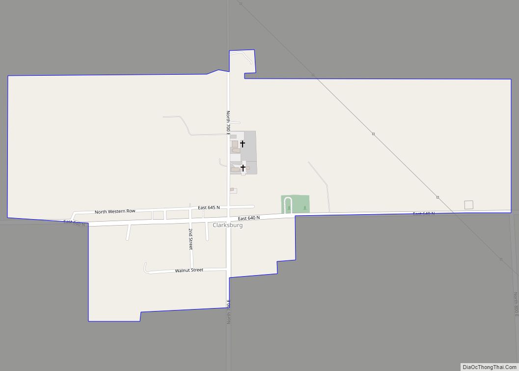
Clarksburg is an unincorporated community and census-designated place in Fugit Township, Decatur County, Indiana, United States. As of the 2010 census, the population of Clarksburg was 149. Clarksburg CDP overview: Name: Clarksburg CDP LSAD Code: 57 LSAD Description: CDP (suffix) State: Indiana County: Decatur County Elevation: 1,056 ft (322 m) Total Area: 0.48 sq mi (1.24 km²) Land Area: 0.48 sq mi ... Read more
Map of US Cities and Places
Clarks Hill is a town in Lauramie Township, Tippecanoe County, in the U.S. state of Indiana. The population was 611 at the 2010 census. It is part of the Lafayette, Indiana Metropolitan Statistical Area. Clarks Hill town overview: Name: Clarks Hill town LSAD Code: 43 LSAD Description: town (suffix) State: Indiana County: Tippecanoe County Elevation: ... Read more
Clarksville is a town in Clark County, Indiana, United States, along the Ohio River and is a part of the Louisville Metropolitan area. The population was 22,333 at the 2020 census. The town was founded in 1783 by early resident George Rogers Clark at the only seasonal rapids on the entire Ohio River, it is ... Read more
Clayton town overview: Name: Clayton town LSAD Code: 43 LSAD Description: town (suffix) State: Indiana County: Hendricks County FIPS code: 1813366 Online Interactive Map Clayton online map. Source: Basemap layers from Google Map, Open Street Map (OSM), Arcgisonline, Wmflabs. Boundary Data from Database of Global Administrative Areas. Clayton location map. Where is Clayton town? Clayton ... Read more
Claypool is a town in Clay Township, Kosciusko County, in the U.S. state of Indiana. The population was 431 at the 2010 census. Claypool town overview: Name: Claypool town LSAD Code: 43 LSAD Description: town (suffix) State: Indiana County: Kosciusko County Elevation: 889 ft (271 m) Total Area: 0.25 sq mi (0.65 km²) Land Area: 0.24 sq mi (0.63 km²) Water Area: 0.01 sq mi ... Read more
Clay City is a town in Harrison Township, Clay County, Indiana, United States. The population was 861 at the 2010 census. It is part of the Terre Haute Metropolitan Statistical Area. Clay City town overview: Name: Clay City town LSAD Code: 43 LSAD Description: town (suffix) State: Indiana County: Clay County Elevation: 594 ft (181 m) Total ... Read more
Clifford is a town in Flat Rock Township, Bartholomew County, Indiana, United States. The population was 233 at the 2010 census. It is part of the Columbus, Indiana metropolitan statistical area. Clifford town overview: Name: Clifford town LSAD Code: 43 LSAD Description: town (suffix) State: Indiana County: Bartholomew County Elevation: 659 ft (201 m) Total Area: 0.09 sq mi ... Read more
Clermont is a town in Pike and Wayne townships of Marion County, Indiana, United States. The population was 1,384 at the 2020 census. It has existed as an “included town” since 1970, when it was incorporated into Indianapolis as part of Unigov. It is legally part of Indianapolis, while retaining a town government under IC ... Read more
Clear Lake is a town located in the northeast corner of Steuben County, Indiana, in Clear Lake Township. As such, is the northeasternmost community in the State of Indiana. The population was 339 at the 2010 census. Clear Lake town overview: Name: Clear Lake town LSAD Code: 43 LSAD Description: town (suffix) State: Indiana County: ... Read more
Coalmont is an unincorporated community and census-designated place in Lewis Township, Clay County, Indiana, United States. It is part of the Terre Haute Metropolitan Statistical Area. As of the 2010 census it had a population of 402. Coalmont CDP overview: Name: Coalmont CDP LSAD Code: 57 LSAD Description: CDP (suffix) State: Indiana County: Clay County ... Read more
Cloverdale is a town in Cloverdale and Warren townships, Putnam County, in the U.S. state of Indiana. The population was 2,172 at the 2010 census. Cloverdale town overview: Name: Cloverdale town LSAD Code: 43 LSAD Description: town (suffix) State: Indiana County: Putnam County Elevation: 820 ft (250 m) Total Area: 3.55 sq mi (9.20 km²) Land Area: 3.49 sq mi (9.03 km²) Water ... Read more
Clinton is a city in Clinton Township, Vermillion County, in the U.S. state of Indiana. The population was 4,893 at the 2010 census. Clinton city overview: Name: Clinton city LSAD Code: 25 LSAD Description: city (suffix) State: Indiana County: Vermillion County Elevation: 495 ft (151 m) Total Area: 2.28 sq mi (5.90 km²) Land Area: 2.25 sq mi (5.83 km²) Water Area: 0.03 sq mi ... Read more