Map of Cedar Grove town, Indiana
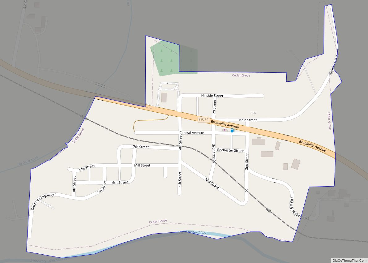
Cedar Grove is a town in Highland Township, Franklin County, Indiana, United States. The population was 156 at the 2010 census. Cedar Grove town overview: Name: Cedar Grove town LSAD Code: 43 LSAD Description: town (suffix) State: Indiana County: Franklin County Elevation: 600 ft (183 m) Total Area: 0.16 sq mi (0.41 km²) Land Area: 0.15 sq mi (0.39 km²) Water Area: 0.01 sq mi ... Read more
Map of Cedar Grove town, Indiana
Map of Center Point town, Indiana
Center Point is a town in Sugar Ridge Township, Clay County, Indiana, United States. The population was 242 at the 2010 census. It is part of the Terre Haute Metropolitan Statistical Area. Center Point town overview: Name: Center Point town LSAD Code: 43 LSAD Description: town (suffix) State: Indiana County: Clay County Elevation: 656 ft (200 m) ... Read more
Map of Center Point town, Indiana
Map of Cedar Lake town
Cedar Lake is a town in Hanover and Center townships, Lake County, Indiana, United States. It is near the Illinois state line. Its population was 11,560 at the 2010 census. The town is notable for its location on Cedar Lake, the Lake of the Red Cedars museum, and veteran charity organization Operation Combat Bikesaver. Cedar ... Read more
Map of Cedar Lake town
Map of Chandler town, Indiana
Chandler is a town straddling Ohio and Boon Township in Warrick County, Indiana, United States, located just east of Evansville, Indiana along the Ohio River. The population was 3,693 at the 2020 census, making it Warrick County’s second-most populous municipality after Boonville. The town is part of the Evansville metropolitan area with a population of ... Read more
Map of Chandler town, Indiana
Map of Chalmers town
Chalmers is a town in Big Creek Township, White County in the U.S. state of Indiana. Its population was 508 at the 2010 census. Chalmers town overview: Name: Chalmers town LSAD Code: 43 LSAD Description: town (suffix) State: Indiana County: White County Incorporated: 1892 Elevation: 715 ft (218 m) Total Area: 0.30 sq mi (0.78 km²) Land Area: 0.30 sq mi (0.78 km²) ... Read more
Map of Chalmers town
Map of Centerville town, Indiana
Centerville is a town in Center Township, Wayne County, in the U.S. state of Indiana. The population was 2,552 at the 2010 United States Census. Centerville town overview: Name: Centerville town LSAD Code: 43 LSAD Description: town (suffix) State: Indiana County: Wayne County Elevation: 1,014 ft (309 m) Total Area: 3.54 sq mi (9.17 km²) Land Area: 3.52 sq mi (9.11 km²) Water ... Read more
Map of Centerville town, Indiana
Map of Chesterton town
Chesterton is a town in Westchester, Jackson and Liberty townships in Porter County, in the U.S. state of Indiana. The population was 14,241 at the 2020 Census. The three towns of Chesterton, Burns Harbor, and Porter are known as the Duneland area. Chesterton town overview: Name: Chesterton town LSAD Code: 43 LSAD Description: town (suffix) ... Read more
Map of Chesterton town
Map of Chesterfield town, Indiana
Chesterfield is a town in the U.S. state of Indiana which lies in Union Township, Madison County, and Salem Township, Delaware County. The population was 2,490 at the 2020 census. It is part of the Indianapolis–Carmel–Anderson metropolitan statistical area. Chesterfield town overview: Name: Chesterfield town LSAD Code: 43 LSAD Description: town (suffix) State: Indiana County: ... Read more
Map of Chesterfield town, Indiana
Map of Charlestown city, Indiana
Charlestown is a city located within Charlestown Township, in Clark County, Indiana, United States. The population was 7,775 at the 2020 census. Charlestown city overview: Name: Charlestown city LSAD Code: 25 LSAD Description: city (suffix) State: Indiana County: Clark County Elevation: 591 ft (180 m) Total Area: 11.49 sq mi (29.75 km²) Land Area: 11.45 sq mi (29.65 km²) Water Area: 0.04 sq mi (0.10 km²) ... Read more
Map of Charlestown city, Indiana
Map of Cicero town, Indiana
Cicero is a town in Jackson Township, Hamilton County, Indiana, United States, north of Indianapolis. The population was 4,812 at the 2010 census. Cicero is notable for welcoming teenaged AIDS activist Ryan White to its community in 1987. White is buried in Cicero. Cicero town overview: Name: Cicero town LSAD Code: 43 LSAD Description: town ... Read more
Map of Cicero town, Indiana
Map of Churubusco town
Churubusco (/ˌtʃɛrəˈbʌskoʊ/ or /ˌtʃɛriˈbʌsɡoʊ/); often shortened to Busco (/ˈbʌskoʊ/), is a town located near the headwaters of the Eel River in the extreme northeast corner of Whitley County, Indiana, United States, in Smith Township, about 16 miles (26 km) northwest of Fort Wayne. The population was 1,796 at the 2010 census. Churubusco town overview: Name: Churubusco ... Read more
Map of Churubusco town
Map of Chrisney town
Chrisney is a town in Grass Township, Spencer County, in the U.S. state of Indiana. The population was 481 at the 2010 census. Chrisney town overview: Name: Chrisney town LSAD Code: 43 LSAD Description: town (suffix) State: Indiana County: Spencer County Elevation: 472 ft (144 m) Total Area: 0.73 sq mi (1.90 km²) Land Area: 0.71 sq mi (1.83 km²) Water Area: 0.03 sq mi ... Read more
Map of Chrisney town