Map of Merrillville town
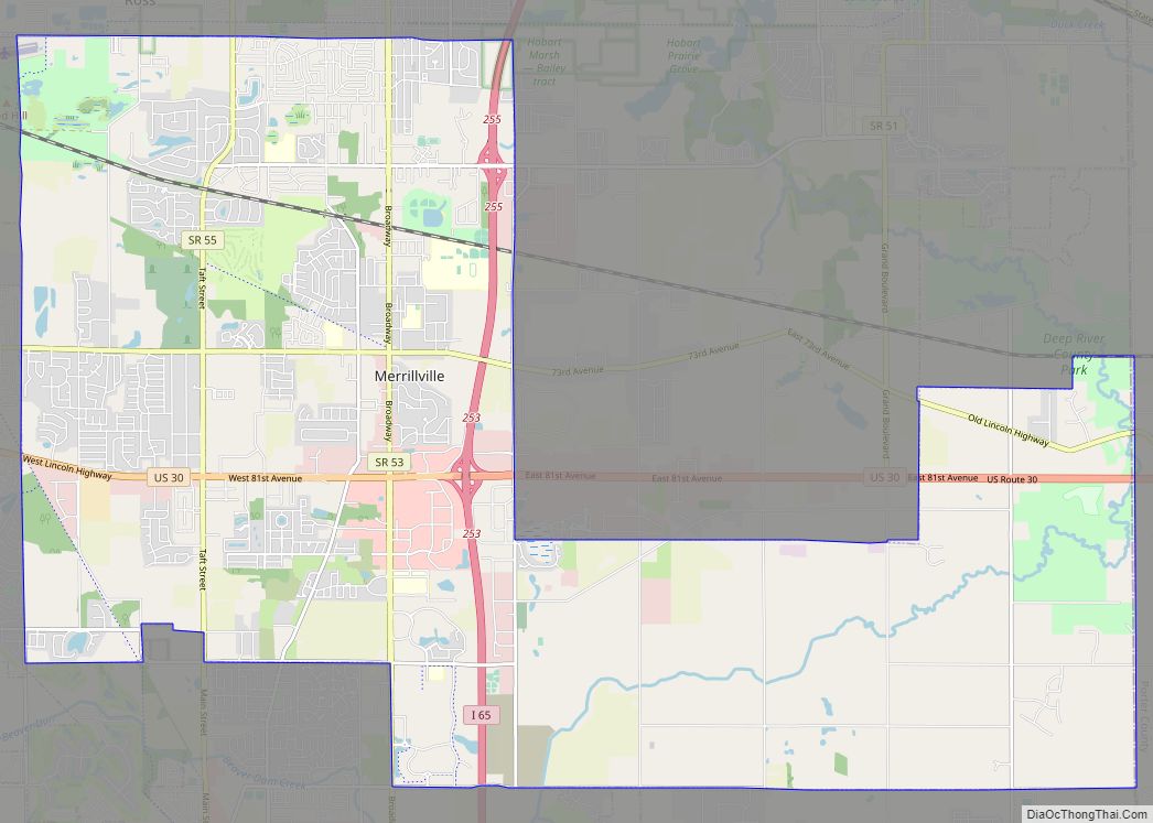
Merrillville /ˈmɛrəlvɪl/ is a town in Ross Township, Lake County, Indiana, United States. The population was 35,246 at the 2010 census. Merrillville is in east-central Lake County, in the Chicago metropolitan area. On January 1, 2015, Merrillville became the most populated town in Indiana, as Fishers in Hamilton County was converted from a town to ... Read more
Map of Merrillville town
Map of Merom town
Merom is a town in Gill Township, Sullivan County, Indiana, United States. The population was 228 at the 2010 census. It is part of the Terre Haute Metropolitan Statistical Area. Nearby is Hallador Energy’s Merom Generating Station. Merom town overview: Name: Merom town LSAD Code: 43 LSAD Description: town (suffix) State: Indiana County: Sullivan County ... Read more
Map of Merom town
Map of Michigan City, Indiana
Michigan City is a city in LaPorte County, Indiana, United States. It is one of the two principal cities of the Michigan City-La Porte, Indiana Metropolitan statistical area, which is included in the Chicago-Naperville-Michigan City Combined statistical area. In the region known to locals as Michiana, the city is about 50 miles (80 km) east of ... Read more
Map of Michigan City, Indiana
Map of Michiana Shores town
Michiana Shores is a town in Springfield and Michigan townships, LaPorte County, Indiana, United States. The population was 313 at the 2010 census. It is included in the Michigan City, Indiana–La Porte, Indiana Metropolitan Statistical Area. Michiana Shores is located in northwesternmost Springfield Township, and is the township’s sole incorporated community. Michiana Shores takes its ... Read more
Map of Michiana Shores town
Map of Mexico CDP, Indiana
Mexico is an unincorporated community and census-designated place (CDP) in Jefferson Township, Miami County, in the U.S. state of Indiana. The population was 915 at the 2020 census. Mexico CDP overview: Name: Mexico CDP LSAD Code: 57 LSAD Description: CDP (suffix) State: Indiana County: Miami County Elevation: 702 ft (214 m) Total Area: 5.56 sq mi (14.40 km²) Land Area: ... Read more
Map of Mexico CDP, Indiana
Map of Middletown town, Indiana
Middletown is a town in northwest Henry County, Indiana, United States. The population was 2,322 at the 2010 census. Middletown town overview: Name: Middletown town LSAD Code: 43 LSAD Description: town (suffix) State: Indiana County: Henry County Elevation: 978 ft (298 m) Total Area: 1.16 sq mi (3.01 km²) Land Area: 1.16 sq mi (3.00 km²) Water Area: 0.00 sq mi (0.01 km²) Total Population: 2,255 ... Read more
Map of Middletown town, Indiana
Map of Middlebury town, Indiana
Middlebury is a town in Middlebury Township, Elkhart County, Indiana, United States. It is located approximately 35 miles east of South Bend, 130 miles east of Chicago, Illinois and 165 miles north of Indianapolis. Middlebury is nestled in Northern Indiana’s Amish country. As of the 2010 census, the town population was 3,420. Middlebury town overview: ... Read more
Map of Middlebury town, Indiana
Map of Michigantown town
Michigantown is a town in Michigan Township, Clinton County, Indiana, United States. The population was 467 at the 2010 census. The town was named for the Michigan Road, an early thoroughfare through the area. Michigantown town overview: Name: Michigantown town LSAD Code: 43 LSAD Description: town (suffix) State: Indiana County: Clinton County Founded: 1830 Elevation: ... Read more
Map of Michigantown town
Map of Milford town, Indiana
Milford is a town in Van Buren Township, Kosciusko County, in the U.S. state of Indiana. The population was 1,614 at the 2020 census. Milford town overview: Name: Milford town LSAD Code: 43 LSAD Description: town (suffix) State: Indiana County: Kosciusko County Elevation: 833 ft (254 m) Total Area: 1.47 sq mi (3.82 km²) Land Area: 1.45 sq mi (3.76 km²) Water Area: ... Read more
Map of Milford town, Indiana
Map of Milan town, Indiana
Milan (/ˈmaɪlən, ˈmaɪlæn/ MY-lən, MY-lan) is a town in Franklin and Washington townships, Ripley County, in the U.S. state of Indiana. The population was 1,899 at the 2010 census. Milan High School won the Indiana state basketball championship against Muncie Central High School in 1954, the victory being significant as Milan was one of the ... Read more
Map of Milan town, Indiana
Map of Mier CDP
Mier is an unincorporated community and census-designated place (CDP) in Richland Township, Grant County, Indiana, in the United States. As of the 2010 census it had a population of 78. Mier CDP overview: Name: Mier CDP LSAD Code: 57 LSAD Description: CDP (suffix) State: Indiana County: Grant County Elevation: 820 ft (250 m) Total Area: 0.24 sq mi (0.62 km²) ... Read more
Map of Mier CDP
Map of Millhousen town
Millhousen is a town in Marion Township, Decatur County, Indiana, United States. The population was 149 at the 2020 census. Millhousen is perhaps best known for being the home of the Immaculate Conception Church, one of only four Roman Catholic churches in Decatur County, and Stone’s Family Restaurant, one of the best known restaurants in ... Read more
Map of Millhousen town